
Forecast for the Skyline Area Mountains

Issued by Brett Kobernik on
Saturday morning, February 15, 2025
Saturday morning, February 15, 2025
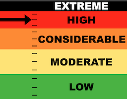
The avalanche danger on the Skyline is HIGH today.
There is a serious threat of dangerous human triggered avalanches.
The tricky thing is that it may not seem very dangerous. You may not see any recent avalanches. The snow may feel solid underneath you. Don't be fooled. There are numerous layers of weak snow that now have a new load of snow on top just waiting for a trigger.
Low
Moderate
Considerable
High
Extreme
Learn how to read the forecast here
Avalanche Warning
What
The avalanche danger for the warning area is HIGH today and may rise to EXTREME in some areas this weekend.
When
Very dangerous avalanche conditions are expected through the weekend.
Where
For all the mountains of Utah and Southeast Idaho, including the Wasatch Range, Bear River Range, Uinta Mountains, Wasatch Plateau, Manti Skyline, the La Sal Mountains, the Tushar Range....
Impacts
Heavy snow and drifting by strong winds have created widespread areas of unstable snow and very dangerous avalanche conditions at all elevations. Natural and human-triggered avalanches are likely. People should avoid travel in all avalanche terrain and keep out of avalanche runouts. This means you should stay off of and out from under slopes steeper than 30 degrees.
 Weather and Snow
Current Conditions: The Skyline picked up another 6 inches or so of new snow in the last 24 hours. Totals are 10 to 12 inches across the range. The Fairview/Electric Lake areas did the best with a solid foot and almost 2 inches of water. Overall, the new snow is fairly dense. Temperatures were in the mid 20s on Friday then cooled into the upper teens overnight. The wind shifted and is from the northwest still in the moderate speed category but increasing a bit. Riding conditions have improved. Skiing is quite excellent. Snowmobiling is ok. You'll still feel chunky stuff under the new snow. It's not the bottomless float that we all want.
Mountain Weather: The storm is coming to an end. We may see a little snowfall still this morning. Maybe a trace to a few inches is all. Wind from the northwest looks like it might get a bit breezy this morning. Looks like temperatures will get back into the low 20s.

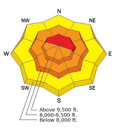
Avalanche Problem #1
New Snow
Type
Location

Likelihood
Size
Description
I found the new snow to be "inverted" or "upside down" in some areas on Friday. It was cracking and I could get it to easily shear in tests. This indicates that the new snow is somewhat unstable. You may trigger avalanches involving just the new snow today. There is enough new snow in many areas that these new snow avalanches could be dangerous. However, this is not the most dangerous situation right now. See below.
.
Avalanche Problem #2
Persistent Weak Layer
Type
Location
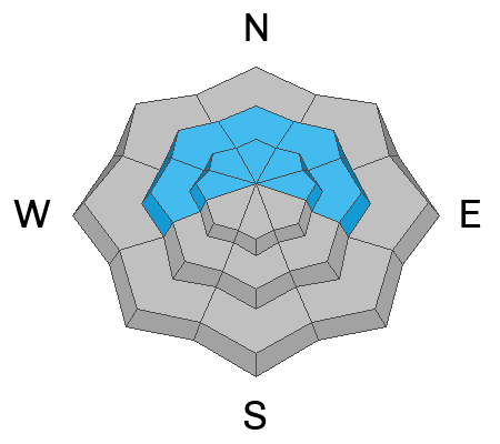
Likelihood
Size
Description
Numerous layers of weak sugary faceted snow exist throughout the snowpack. We've just added 1 to 2 inches of water weight on top of these layers. Wind may increase today which will drift snow, piling up even more on top of the pre-existing weak layers. If you trigger something that breaks deep, it's not going to be good. If you are monkeying around on or below big steep slopes, it's a roll of the dice.
General Announcements
This forecast is from the U.S.D.A. Forest Service, which is solely responsible for its content. This forecast describes general avalanche conditions and local variations always occur.