Forecast for the Skyline Area Mountains

Brett Kobernik
Issued by Brett Kobernik on
Sunday morning, February 16, 2025
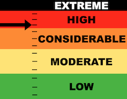
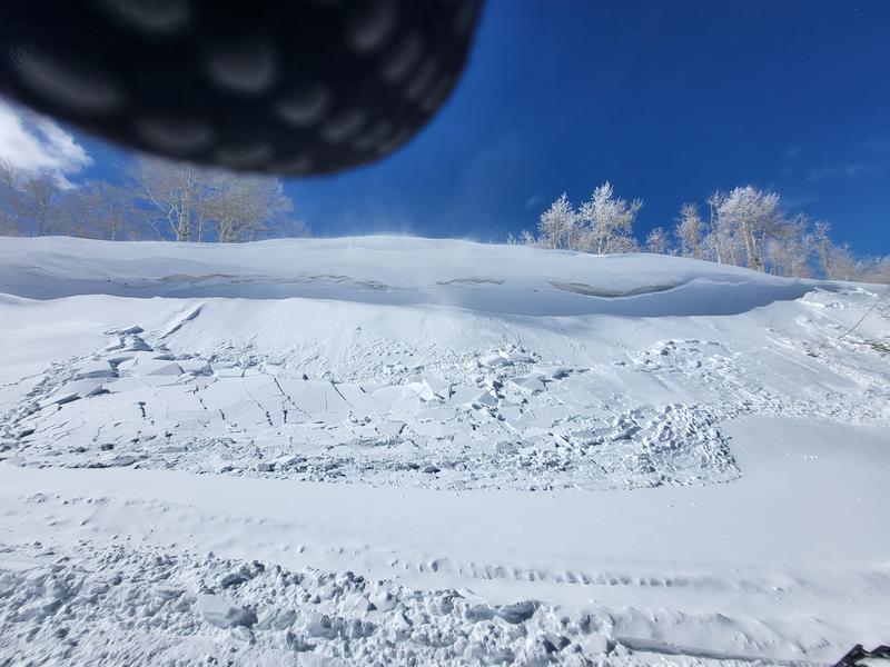
The avalanche danger on the Skyline is HIGH today.
Wind has been moving lots of snow and loading the more east facing slopes. More wind is expected today.
Avalanches may release naturally today. Human triggered avalanches are quite likely on the wind loaded slopes.
Low
Moderate
Considerable
High
Extreme
Learn how to read the forecast here
Avalanche Warning
We are continuing the AVALANCHE WARNING through today.
This is meant to be an extra "HEADS UP" that dangerous conditions exist and you should avoid steep avalanche terrain to stay safe.
Weather and Snow
Current Conditions: Wind makes the headlines today. It got pretty crazy along the high ridges on Saturday drifting snow all over the place. We went to a meadow at 9000' that is usually protected and holds good riding conditions and found it absolutely blasted. It's going to be hit or miss our there today. Temperatures got up to around 20˚F Saturday and dropped back into the low to mid teens overnight.
Mountain Weather: Wind also headlines today's weather forecast. Speeds slowed a little this morning but it looks like it's going to ramp right back up again and be strong by mid day from the west. Skies start out partly cloudy and we'll most likely see more clouds moving in during the day. Temperatures are going to warm and max out in the upper 20s to around 30˚F. The weather looks unsettled through the week. There's a chance for light snowfall tonight and Monday which might add a few inches. Then another more organized system could bring a better chance of snow accumulations around Thursday.
Recent Avalanches
Travel was difficult due to poor visibility on Saturday so I didn't get a good look around to see activity from the storm. But some people contacted me and confirmed that there were some natural avalanches that released during the storm. Some involved just the new snow. (photo below) Some were breaking into the January faceted weak layer.
New snow soft slab that released under a cornice. Photo: Dave Defriez
Ad
Avalanche Problem #1
Persistent Weak Layer
Type
Location
Likelihood
Size
Description
There are weak layers of loose sugary faceted snow everywhere you look in the mid and upper elevations. We had layers form in November, December and January so pick your poison. The January facets are the loosest and that's where the majority of avalanches will fail today. However, with the wind moving massive amounts of snow, I won't be surprised to see something break deeper.
WIND IS THE BIG PLAYER TODAY.
It is imperative to avoid steep avalanche terrain where the wind is depositing snow forming drifts and slabs. The most dangerous places by far today are on steep southeast, east and northeast facing slopes. These slopes will have the deepest drifts and slabs. Some may release naturally. Many just need a trigger like a skier or snowmobiler.
.
General Announcements
This forecast is from the U.S.D.A. Forest Service, which is solely responsible for its content. This forecast describes general avalanche conditions and local variations always occur.