Forecast for the Skyline Area Mountains

Brett Kobernik
Issued by Brett Kobernik on
Friday morning, February 14, 2025
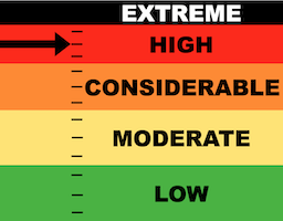
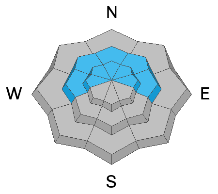
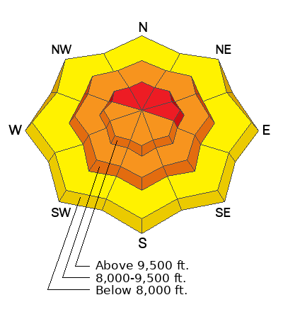
The avalanche danger on the Skyline is HIGH today.
Avalanches may release naturally. Human triggered avalanches are very likely.
Currently the danger is more pronounced around the Fairview Canyon zone which has received the most new snow.
Low
Moderate
Considerable
High
Extreme
Learn how to read the forecast here
Avalanche Warning
What
The avalanche danger for the warning area is HIGH today and may rise to EXTREME in some areas this weekend.
When
Very dangerous avalanche conditions are expected through the weekend.
Where
For all the mountains of Utah and Southeast Idaho, including the Wasatch Range, Bear River Range, Uinta Mountains, Wasatch Plateau, Manti Skyline, the La Sal Mountains, the Tushar Range....
Impacts
Heavy snow and drifting by strong winds have created widespread areas of unstable snow and very dangerous avalanche conditions at all elevations. Natural and human-triggered avalanches are likely. People should avoid travel in all avalanche terrain and keep out of avalanche runouts. This means you should stay off of and out from under slopes steeper than 30 degrees.
Weather and Snow
Current Conditions: Most of the storm action has been around the Fairview Lakes area which has picked up around 10 inches of new snow. The central and southern end of the range is only in the 3 to 5 inch range. This is a common pattern with a southwest flow like what is happening with this storm. Southwest flow favors the northern end around the Fairview Lakes area. The wind has been from the southwest in the moderate speed range with some stronger gusts in the highest terrain. Temperatures have been fairly steady in the mid 20s.
Mountain Weather: There's a little break in the action right now but the storm will continue through today into Saturday with an additional 6 to 12 inches of snow possible. Wind from the southwest will slow a bit but remain in the moderate speed category. The direction will slowly shift and come from the northwest by late in the day. Temperatures will remain in the mid to upper 20s.
Ad
Avalanche Problem #1
New Snow
Type
Location
Likelihood
Size
Description
The first thing you should look out for is how the new snow is behaving. Watch for cracking around your skis, snowboards or machines. Use small steep test slopes with no consequences to see if you can initiate cracking as you ski or ride across them. Watch for areas where the wind has drifted the snow forming pillows and slabs. These areas are the most likely places to trigger something. All that said, the new snow is really the least of our concerns. See below. .
Avalanche Problem #2
Persistent Weak Layer
Type
Location
Likelihood
Size
Description
By far the biggest threat is triggering an avalanche that breaks deep into pre-existing weak sugary layers of faceted snow. These layers have been forming all season and now we are adding weight on top with the new snow and wind blown snow. It is difficult to predict which slopes will release and which will stay in place. The most likley places to trigger a deep and dangerous avalanche are on very steep slopes in the mid and upper elevations that face north through east. Keep in mind that there is plenty of weak layers scattered all over the place right now. The safest bet is to simply avoid steep slopes right now.
General Announcements
This forecast is from the U.S.D.A. Forest Service, which is solely responsible for its content. This forecast describes general avalanche conditions and local variations always occur.