Forecast for the Logan Area Mountains

Toby Weed
Issued by Toby Weed on
Wednesday morning, December 18, 2024
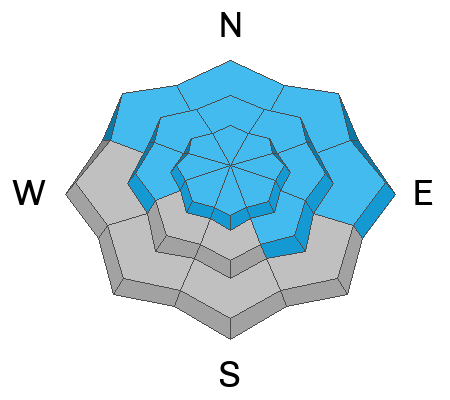
Heavy new snow and strong winds have created HIGH avalanche danger at upper elevations on drifted slopes facing northwest through east in the northern and central Bear River Range. People are likely to trigger dangerous slab avalanches of wind-drifted storm snow failing on a sugary, persistent weak layer that is now buried 1 to 3 feet deep. Dangerous avalanche conditions and CONSIDERABLE danger exist on many other upper and mid-elevation slopes in the Logan Zone, and elevated avalanche conditions exist on slopes with preexisting snow at all elevations. Avalanches could be triggered remotely (from a distance) or from below!
We advise that people stay off and out from under drifted slopes steeper than 30° and stay clear of avalanche runouts.
Low
Moderate
Considerable
High
Extreme
Learn how to read the forecast here
Special Announcements
Gear up for the season or score great deals on gifts for loved ones this holiday season while supporting the UAC’s efforts. Your participation directly funds the state's avalanche forecasting, awareness, and education programs. Check out the auction found here!
Weather and Snow
In exposed terrain at upper elevations, drifting snow overloaded slopes with weak faceted snow. Upper elevation slopes in the Central Bear River Range picked up about 10 inches of heavy new snow yesterday and solid foot over the weekend, with the Tony Grove Snotel reporting around 3.4 inches of SWE (Snow Water Equivalent.) All the new snow plus consistent strong westerly winds have created dangerous avalanche conditions. With an exceptionally weak snowpack, avalanches are likely in steep, wind-loaded terrain. Conditions are less dangerous but it is too shallow to ride on low elevation and sunny slopes that had very shallow snow cover or were bare before last weekend's storm.
-The Tony Grove Snotel at 8400 feet above sea level reports 26° F, with about 10 inches of new snow in the last 48 hours, and there is 35 inches of total snow at the site
-Winds on Logan Peak are blowing from the west 25 to 30 mph with gusts up to 41 mph, and it's 21° F this morning.
-It's 23° F at Card Canyon with 31 inches of total snow.
-On Paris Peak at 9500 feet its 20° F with south-southwest winds blowing 25 to 30 mph.

This is the NWS point forecast for Naomi Peak Area:
Today: Mostly sunny, with a high near 33. West wind 6 to 14 mph.
Tonight: Mostly clear, with a low around 21. West wind 5 to 10 mph.
Thursday: Sunny, with a high near 37. West wind around 6 mph.
For more information, visit the UAC weather page here: Weather - Utah Avalanche Center
For Logan-specific weather, go here: Logan Mountain Weather - Utah Avalanche Center
Recent Avalanches
I noticed two fresh avalanches that ran into the Logan River in the steep corners below Temple Fork. A fairly wide but shallow natural soft slab avalanche occurred in Beaver Canyon across Highway 89 from backside parking.
You can read all recent local observations here.
Ad
Avalanche Problem #1
Wind Drifted Snow
Type
Location
Likelihood
Size
Description
With sustained strong winds and heavy snowfall, natural avalanches are possible, and human-triggered avalanches are likely. Avalanches of stiffer wind-drifted snow could be one to three feet deep. Our upper and mid-elevation snowpack consists of mostly weak, sugary, faceted snow, and it will not support the added weight of drifted snow.
  • Nartural and remotely triggered avalanches, as well as cracking and collapsing (whumpfs) are sure signs of unstable snow. These "Red Flags" were in your face this weekend and yesterday, reported in all observations.
  • Avalanches today are likely to be triggered remotely (from a distance) or from below.
  • A ride in even a small avalanche is especially dangerous in the early season due to buried obstacles like rocks, stumps, and downed trees.
Avalanche Problem #2
New Snow
Type
Location
Likelihood
Size
Description
The Central Bear River Range has picked up around 3.4 inches of SWE since Saturday. Soft storm slabs of new snow failing on last week's weak surface snow or within the newer snow are likely even in sheltered terrain on slopes steeper than about 30°. Avalanches of storm snow are most likely up high but possible at all elevations and on slopes facing all directions.
Avalanche Problem #3
Persistent Weak Layer
Type
Location
Likelihood
Size
Description
Very weak and sugary faceted snow exists on almost all northerly-facing slopes at upper and mid-elevations. Low elevation and southerly terrain was bare of snow or had only very shallow coverage before this weekend's storm.
Additional Information
Sunday, Liam and Paige were getting large collapses or whumpfs in mid-elevation terrain when they stepped off the skin track. It is a great example of how wind-loaded snow behaves when it lands on weak, faceted snow.

General Announcements
-National Forest Winter Recreation Travel Maps show where it's open to ride: UWCNF Logan, Ogden LRD Tony Grove, Franklin Basin CTNF Montpelier
-Sign up for forecast region-specific text message alerts. You will receive messages about changing avalanche conditions, watches, and warnings...HERE.
-For all questions on forecasts, education, Know Before You Go, events, online purchases, or fundraising, call 801-365-5522.
-To report an avalanche or submit an observation from the backcountry, go HERE.
-Remember that the Tony Grove Road is not maintained for winter driving. Treacherous snow-covered and icy conditions will be encountered.

This forecast is from the U.S.D.A. Forest Service, which is solely responsible for its content. This forecast describes general avalanche conditions, and local variations always occur.