Forecast for the Provo Area Mountains

Issued by Dave Kelly on
Monday morning, December 16, 2024
Monday morning, December 16, 2024
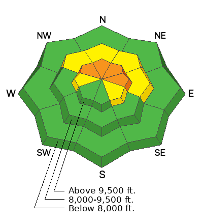
Today, there is a CONSIDERABLE avalanche danger on upper elevation northwest-north-east facing aspects for triggering a wind-drifted snow avalanche failing on buried facets. These avalanches could be 2'-3' deep and up to 100' wide running up to 400' vertical. There is a MODERATE avalanche danger on upper elevation west and southeast aspects and mid elevation northwest-north-east facing terrain. The avalanche danger is LOW on all other aspects.
Recently formed wind slabs may be supportive enough to allow you to get further onto the slope before they break, making them all the more dangerous. Cautious route finding and conservative decision making is essential.
Recently formed wind slabs may be supportive enough to allow you to get further onto the slope before they break, making them all the more dangerous. Cautious route finding and conservative decision making is essential.

Low
Moderate
Considerable
High
Extreme
Learn how to read the forecast here
 Special Announcements
Gear up for the season or score great deals on gifts for loved ones this holiday season while supporting the UAC’s efforts. Your participation directly funds the state's avalanche forecasting, awareness, and education programs. Check out the auction found HERE.
 Weather and Snow
This morning, under partly cloudy skies temperatures are in the mid-teens to low 20's °F. Winds are blowing lightly at the lower elevations and blowing from the southwest in the teens gusting to the low 20's MPH at the higher elevation weather stations. There was no new snow reported overnight.
For today, look for partly cloudy skies with temperatures 35-40 °F and winds blowing from the southwest 10 gusting to 15MPH at the 9,000' ridgelines and 25 gusting to 35 MPH at the 11,000' ridgelines. There is a trace of new snow forecast to start later in the afternoon. For the most up to date weather station information check out the UAC's new weather tab HERE.
Snow depths now range from 8"-14" at lower elevation weather stations in the forecast region, with more snow in the upper elevations in the northern part of the forecast region.
 Recent Avalanches
Yesterday, we had no avalanches reported from the Provo Area Mountains.
Avalanche Problem #1
Persistent Weak Layer
Type
Location

Likelihood
Size
Description
We now have two buried weak layers in our immature snowpack. One is a layer of facets located 1"-8" off the ground and the other is a buried surface weakness that formed during the early December high pressure and is just under the newest snow. The one near the ground is easy to see in snowpits and is the classic weak snow with strong snow over the top.
The harder to find surface weakness is now buried 6"-12" under the most recent new snow and wind. This weak snow will be spotty as it may have been destroyed by high winds and warm temperatures before it was buried by the most recent storm snow.
In observations from just north of the Provo region there have been reports of collapsing, cracking, and whumpfing. These are all signs that the snowpack is adjusting and if you see/hear these signs, or see recent avalanche activity then back off and find a lower angle slope to travel on.
Avalanche Problem #2
Wind Drifted Snow
Type
Location

Likelihood
Size
Description
Strong southerly winds over the last few days have loaded slopes in mid and upper elevation terrain. The nature of the strong winds is that they can load slopes in odd patterns and may not always distribute snow equally across a slope. Look for areas of wind loading such as thick, pillowy drifts of snow and avoid those slopes. Some of the winds have loaded snow in gully features that may have thin weak snow underneath. These are the zones where you are more likely to trigger an avalanche.
General Announcements
This information does not apply to developed ski areas or highways where avalanche control is normally done. This forecast is from the U.S.D.A. Forest Service, which is solely responsible for its content. This forecast describes general avalanche conditions and local variations always occur.


