Join us at our 2nd Annual Blizzard Ball

Forecast for the Provo Area Mountains

Trent Meisenheimer
Issued by Trent Meisenheimer on
Sunday morning, December 15, 2024
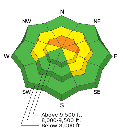
The avalanche danger is CONSIDERABLE on upper-elevation slopes facing northwest, north, northeast, and east, where it's likely to trigger a persistent weak-layer avalanche. Here, avalanches may be triggered from a distance (remotely) and could be large enough to bury a human. We also have a MODERATE avalanche danger for both hard and soft slabs of wind-drifted snow across many aspects and elevations due to the strong wind.
Today, careful snowpack evaluation, cautious route-finding, and conservative decision-making will be essential.
Low
Moderate
Considerable
High
Extreme
Learn how to read the forecast here
Special Avalanche Bulletin
What: Heavy snowfall and drifting by strong winds will cause dangerous avalanche conditions to develop this weekend in the mountains of northern Utah.
When: In effect from 6 am MST this morning through 6 am Monday morning
Where: For the mountains of Northern Utah and Southeastern Idaho, including the Wasatch Range...Bear River Range... and Western Uinta Mountains.
Impacts: Dangerous avalanche conditions will develop on many slopes today. People are likely to trigger avalanches by being on or below slopes steeper than 30 degrees. Avalanches could be triggered remotely (from a distance) or from below.
What to do: Avoid traveling on or underneath steep north-facing terrain at mid and upper elevations in the backcountry. Carry and know how to use avalanche rescue equipment.
Weather and Snow
Overnight, the headline continued to be the southerly wind, which wreaked havoc across the upper elevations, averaging 20 to 30 mph with gusts into the 30s and 40s. We did pick up a trace to 3 inches of new snow (0.01"-0.10" swe) in the past 24 hours.
This morning, it's beginning to snow. The wind has veered west and continues to blow 15 to 25 mph, with gusts into the 20s and 30s along the upper ridgelines. Cascade Peak at 10,800' is blowing 10-20 mph gusting in the upper 20s. Current mountain temperatures have cooled and range from 20 to 28 °F.
Today, we can expect snowfall in the morning hours, with hopefully 3 to 6 inches (0.40"-0.70" swe) of new snow throughout the day. The wind will remain from the west and northwest, at times averaging 10-20 mph with gusts into the 20s and 30s. Mountain temperatures will remain cold as this storm ushers in colder air, with daytime highs topping out in the mid-20s °F.
Video: Grainger & Kelly show the wind drifting yesterday along the BCC/Millcreek ridgeline.
Recent Avalanches
No observations came in yesterday from the Provo area. However, during yesterday's peak winds, we likely saw a natural avalanche cycle within the storm snow. In some cases, with enough wind loading, avalanches broke into weaker faceted snow.
Ad
Avalanche Problem #1
Persistent Weak Layer
Type
Location
Likelihood
Size
Description
On almost all shady slopes across the mid and upper elevations, we have weak and faceted snow (weak layer). Weak snow with heavier, more dense snow on top = avalanches.
Natural and human-triggered avalanches will remain likely today across the upper-elevation wind-loaded terrain. These avalanches could be 1-2 feet deep, up to 100 feet wide, and large enough to bury a human. Today, an avalanche can be triggered remotely, meaning from a distance. I would stick to terrain under 30 degrees in steepness with nothing above or adjacent to you that could avalanche.
Trend: Increasing Danger
Avalanche Problem #2
Wind Drifted Snow
Type
Location
Likelihood
Size
Description
Yesterday's and today's elevated wind will continue loading some slopes while stripping others. In any case, be on the lookout for wind-drifted terrain and avoid areas where the snow looks pillowy, rounded, or hollow like a drum. Today, you will be able to find both hard and soft slabs of wind-drifted snow on a variety of aspects and elevations.
If you trigger a wind-drifted snow avalanche, it's likely to fail within the storm snow or break deeper into faceted snow, making it much larger and more dangerous.
General Announcements
This information does not apply to developed ski areas or highways where avalanche control is normally done. This forecast is from the U.S.D.A. Forest Service, which is solely responsible for its content. This forecast describes general avalanche conditions and local variations always occur.