Join us at our 2nd Annual Blizzard Ball

Forecast for the Skyline Area Mountains

Brett Kobernik
Issued by Brett Kobernik on
Friday morning, November 29, 2024
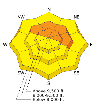
The overall avalanche danger is currently CONSIDERABLE.
Human triggered avalanches are likely today.
The most likely places to trigger an avalanche is on steep slopes above 8000 feet that face northwest through east.
Low
Moderate
Considerable
High
Extreme
Learn how to read the forecast here
Weather and Snow
Current Conditions: I was on skis Thursday and found conditions to be excellent. The snowpack is supportable. We weren't punching deep into the weaker snow near the ground. The surface was excellent Utah powder. Temperatures along the higher ridges are around 20˚F but colder down in the canyons. Wind speeds are light from the southwest.
Mountain Weather: Clear skies and mild weather is what we'll see for the near future. Today's high temperatures should get into the mid 20s to low 30s in the higher terrain. Wind from the west should be light to moderate in speed.
Ad
Avalanche Problem #1
Persistent Weak Layer
Type
Location
Likelihood
Size
Description
While climbing on skis Thursday, my partner and I did not experience any collapsing or "whumpfing" of the snowpack. This tells me that the new snow is settling and the weak snow near the ground is adjusting to it's new load from the last storm. That said, don't get too comfortable. The structure is still "strong snow over weak snow" and anytime you have faceted (sugary) snow buried in the pack, you should be very suspicious. The chances for triggering an avalanche will continue to decrease each day but make no doubt, you can still trigger an avalanche today.
Bottom line: I'm not trusting steep slopes.
General Announcements
This forecast is from the U.S.D.A. Forest Service, which is solely responsible for its content. This forecast describes general avalanche conditions and local variations always occur.