Forecast for the Skyline Area Mountains

Brett Kobernik
Issued by Brett Kobernik on
Saturday morning, March 20, 2021
The avalanche danger is MODERATE today.
If you play around on enough steep slopes you could find a spot where you can trigger an avalanche that breaks down near the ground.
The chances for triggering one of these are pretty low but the consequences are high.
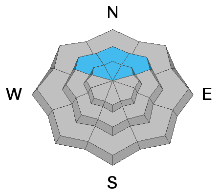
Slopes steeper than about 35˚ above 9500' that are on the north half of the compass are the most likely spots to trigger something.
Be aware that wet avalanche activity in the mid and lower elevations is somewhat a concern today also.
Low
Moderate
Considerable
High
Extreme
Learn how to read the forecast here
Special Announcements
Spring Awareness Campaign - Help us save lives through avalanche forecasts and education. Consider making a donation to show your support. DETAILS HERE.
Weather and Snow
Current Conditions: Temperatures remained quite warm overnight with many stations above freezing. Southwest wind increased a bit more but is still in the moderate speed range. The snow became very damp on Friday to the point where I'd say it was actually wet and sloppy below the higher terrain.
Mountain Weather: It looks like we have a week of active weather ahead. Today will start out scattered clouds and pretty mild with temperatures warming a bit before a well defined cold front moves through later this afternoon bringing a shot of snow. Southwest wind will increase ahead of the cold front then veer northwest. Models indicate around a half inch of water possible so I'm still thinking 3 to 6 inches of snow is likely through tonight. Temperatures remain cool through the week with a number of periods of snow likely. If things hold together, we could see 12 to 20 inches of new snow by next weekend.
Ad
Avalanche Problem #1
Persistent Weak Layer
Type
Location
Likelihood
Size
Description
Avalanche conditions seem quiet but the weak snow still lurks near the ground. While riding my snowmachine Friday, I came to a stop. Two more riders approached and stopped. Two more riders were approaching when the snowpack collapsed, WHOOMP!, and we all felt the snow drop an inch or two below us. This is the Persistent Weak Layer of snow that formed early season and is still a concern. It is quite unusual to be experiencing collapsing like this still this late in the season. Again, things seem quiet as far as avalanches and it seems somewhat unlikely to trigger something but these collapses I've experienced this week along with poor snowpit test results don't give me a whole lot of faith in the snowpack.
Avalanche Problem #2
Wet Snow
Type
Location
Likelihood
Size
Description
I'm a little bit concerned about wet avalanche activity today. Ultimately, I don't think it'll be a serious issue but it's enough of a concern to mention. Things were really pretty sloppy in the mid and lower elevations on Friday. With mild temperatures overnight, the snow may not have frozen up much. Add in the fact that there is weak sugary snow near the ground and all this warming may make things unstable to the point of seeing wet avalanches gouge deep to the ground. Given the weak snowpack, wet snow avalanches are going to be a concern during any significant warm up through the spring.
I would avoid steep slopes where the snowpack is wet and sloppy. If your feet are punching through to the ground, avoid being on or below steep slopes. This includes traveling through steep gullies and ravines.