Forecast for the Skyline Area Mountains

Brett Kobernik
Issued by Brett Kobernik on
Sunday morning, March 21, 2021
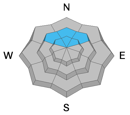
The avalanche danger is MODERATE today above 8000' in elevation.
The new snow itself shouldn't pose much threat. Watch for cracking which would indicate the chance for small avalanches involving the new snow.
There is still a slight chance that a person could trigger an avalanche that breaks into weak snow near the ground. (see Persistent Weak Layer discussion below)
Unless you are getting into pretty radical steep terrain today, avalanche conditions are relatively safe.
Low
Moderate
Considerable
High
Extreme
Learn how to read the forecast here
Special Announcements
Spring Awareness Campaign - Help us save lives through avalanche forecasts and education. Consider making a donation to show your support. DETAILS HERE.
Weather and Snow
Current Conditions: Storm totals are 5 to 8 inches of snow since Saturday. The storm involved a sharp cold front from the northwest. This flow often favors the Ephraim Canyon area which it did last night. Temperatures are around 20˚F and northwest wind is moderate in speed. It is still snowing a bit as of 6:30am.
Mountain Weather: We'll see the chance for lingering snowfall this morning without a whole lot more accumulation expected. It looks like clouds will hang around the mountains all day. Highs will be in the mid 20s and northwest wind will continue in the moderate speed range. Clouds should clear out overnight into Monday morning then build back in ahead of the next system that should bring some more snow Monday night and Tuesday. The event is mainly on Tuesday and looks like it might be good for 4 to 6 inches of new snow. One more system will move through Thursday night bringing another shot of snow.
Ad
Avalanche Problem #1
Persistent Weak Layer
Type
Location
Likelihood
Size
Description
The weight of the new snow won't change the avalanche conditions much but a lingering chance still remains that a person could trigger an avalanche that breaks into weak faceted snow near the ground. The most likely spots are upper elevation very steep slopes on the north half of the compass where the snowpack is less than about 4 feet deep. Collapsing triggered by snowmachines continued this week in just this type of terrain although on lower angled slopes so no avalanches resulted. Had the slopes been steeper, an avalanche would have occurred.