Forecast for the Skyline Area Mountains

Brett Kobernik
Issued by Brett Kobernik on
Friday morning, March 19, 2021
No big change in conditions and the avalanche danger is LOW to MODERATE today.
It is possible to trigger an avalanche that breaks into weak sugary faceted snow near the ground.
The chances for triggering one of these are pretty low but the consequences are high.
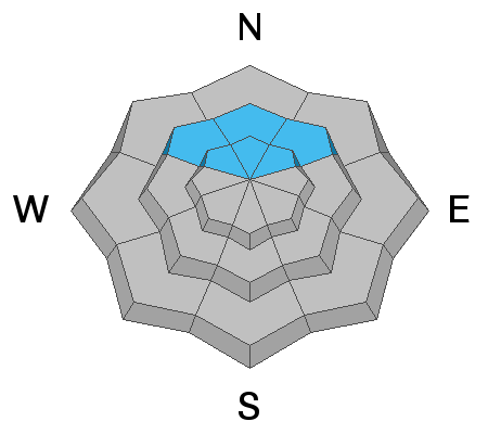
Slopes steeper than about 35˚ above 9500' that are on the north half of the compass are the most likely spots to trigger something.
Low
Moderate
Considerable
High
Extreme
Learn how to read the forecast here
Special Announcements
Spring Awareness Campaign - Help us save lives through avalanche forecasts and education. Consider making a donation to show your support. DETAILS HERE.
Weather and Snow
Current Conditions: Riding conditions remain good in many areas. Most slopes have become damp to a certain extent but conditions remain soft which is nice for turning. The southwest wind increased a bit over the highest terrain but is generally still moderate in speed. Temperatures were a bit warmer overnight with most stations in the mid 20s to around freezing.
Mountain Weather: We'll see plenty of sun today with high temperatures pushing into the low 40s along the higher terrain and moderate speed southwest wind. The big picture is that we'll have an active weather pattern starting Saturday with three different storm troughs moving through from the northwest over the next week. Temperatures cool on Saturday and we'll see a shot of snow Saturday night as the first trough (that looks like it wants to split) moves through. I think 3 to 6 inches of snow is not unreasonable to expect by Sunday. The next chance for snow is Tuesday night and then another chance Thursday night. None of these storms look huge but they all look like they'll bring a little snow.
Ad
Avalanche Problem #1
Persistent Weak Layer
Type
Location
Likelihood
Size
Description
A Persistent Weak Layer of faceted snow near the ground remains a concern. Chances are becoming less for triggering an avalanche that breaks into this weak snow. Here are some things that point to better stability:
  • There is no doubt that warmer temperatures help stabilize the snowpack. This doesn't necessarily strengthen the weak layers near the ground a whole lot but helps strengthen the layers over it that form a bridge.
  • Statistically, avalanches that break into weak faceted snow near the ground at this time of the season are somewhat rare.
  • Many slopes have already avalanched and are unlikely to avalanche again at this time.
Here's the flipside of the coin:
  • The layers of weak sugary faceted snow at the base of the snowpack are much more pronounced than almost anything I've ever seen. It is a very unusual situation.
  • There has been collapsing of the snowpack in shallow areas the last few days.
  • Snowpit stability tests remain poor with full propagation occuring when the weak layers near the ground fail.
While chances for triggering an avalanche that breaks to the ground are fairly slim right now, I still don't feel good knowing that those sugary layers of snow are still lurking and are still VERY loose. I've pretty much sworn off many of my favorite steep slopes which normally I would consider safe at this time of the year.