Forecast for the Skyline Area Mountains

Brett Kobernik
Issued by Brett Kobernik on
Thursday morning, January 7, 2021
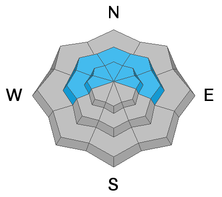
Continue to avoid steep upper elevation west, north and east facing slopes. A CONSIDERABLE danger exists in these areas. Human triggered avalanches are likely.
Cracking and collapsing of the snowpack are red flags and indicate an unstable snowpack.
Low
Moderate
Considerable
High
Extreme
Learn how to read the forecast here
Weather and Snow
Current Conditions: Temperatures got pretty warm on Wednesday with highs into the mid to upper 30s at numerous higher locations. They stayed mild overnight in the mid to upper 20s. Wind has been pretty light. Skiing and snowboarding conditions improved with 2 to 4 inches of new snow on Tuesday. There is still not enough to do much more than ride on roads with snowmobiles.
John Pikus was up in the Fairview Canyon area on Wednesday and submitted some more backcountry observations. I concur with his findings. CLICK HERE FOR DETAILS.
Mountain Weather: It looks like another gorgeous day up in the mountains with plenty of sun, light wind and temperatures in the mid 20s. We'll see more clouds on Friday and another small storm will move through Friday into Saturday bringing a few inches of snow. Current mid range weather model outputs look bleak with no significant storms on the horizon right now.
Ad
Avalanche Problem #1
Persistent Weak Layer
Type
Location
Likelihood
Size
Description
The very weak snowpack structure continues to be our main focus. Although the doors aren't currently coming off the hinges, things are not good. The pack is shallow and weak. My partner and I experienced 15 to 20 significant collapses (WHOOMPS) of the snowpack on Wednesday. We've experienced collapsing every day we've been out since Dec 18. This is Mother Nature screaming at us that the pack is unstable.
Looking forward, unfortunately, with no significant storms in the near future, the snowpack will continue to deteriorate and become weaker.