Forecast for the Skyline Area Mountains

Brett Kobernik
Issued by Brett Kobernik on
Friday morning, January 8, 2021
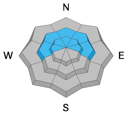
Human triggered avalanches are still likely on steep slopes especially in upper elevation west, north and east facing terrain. A CONSIDERABLE avalanche danger exists in that terrain. Continue to keep your slope angles under 30 degrees if you are traveling in the described terrain.
Low
Moderate
Considerable
High
Extreme
Learn how to read the forecast here
Weather and Snow
Current Conditions: Southwest wind was a bit breezier than I anticipated along the ridges for a few hours Thursday. It has slowed and is almost calm now. Overnight temperatures were around 20˚F or a bit colder in the drainge bottoms. Riding conditions remain good for skiers and snowboarders. Snowmobilers need to follow roads to avoid hitting rocks and stumps under the very thin snowpack.
Mountain Weather: It looks like a nice day today but we'll see some clouds. Temperatures will get into the mid to upper 20s. Wind will be pretty light from the southwest. It will probably increase in speed late this afternoon. A weak storm will move through tonight hopefully brining a few inches of new snow if we're lucky. No other storms are expected for at least a week.
Ad
Avalanche Problem #1
Persistent Weak Layer
Type
Location
Likelihood
Size
Description
While descending a slope on skis Thursday, I watched a crack form and shoot down the hill in front of me. The only reason the slope didn't avalanche was that it was not steep enough. My partner and I also experienced numerous "Whoomps" of the snowpack. All of this indicates that the weak snow near the ground is still very capable of producing avalanches. What's worse is that the longer we go with no significant storms, the weaker the entire snowpack becomes.