Forecast for the Skyline Area Mountains

Brett Kobernik
Issued by Brett Kobernik on
Wednesday morning, January 6, 2021
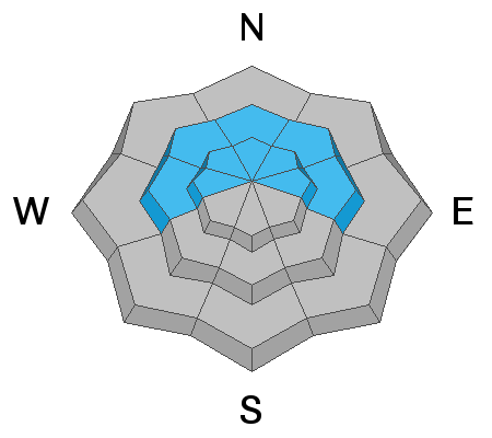
The avalanche danger remains CONSIDERABLE on steep slopes that face west, north and east in the upper elevations. Human triggered avalanches are likely in this terrain due to weak sugary faceted snow near the ground.
Low
Moderate
Considerable
High
Extreme
Learn how to read the forecast here
Weather and Snow
Current Conditions: Wind speeds have dropped off and are now light to moderate from the west. Overnight temperatures are in the mid teens to low 20s. A little more snow trickled in yesterday afternoon bringing us up to 2 to 4 inches of snow since Monday night. Things to note about the storm:
  • The new snow was quite dense.
  • Wind blew the new snow around quite a bit.
John Pikus sums things up really well in some observations he submitted. CLICK HERE FOR DETAILS.
Mountain Weather: We'll see clouds roll through later today. Highs will get up near 30˚F and wind will be light to moderate from the west southwest with a slight increase in speed this afternoon. Thursday looks like a nice day with lots of sun. The next small storm is scheduled for Friday night into Saturday with a few inches of new snow possible.
Ad
Avalanche Problem #1
Persistent Weak Layer
Type
Location
Likelihood
Size
Description
We have slightly different red flags today compared to Tuesday:
  • Dense newer snow
  • Recently formed drifts
  • Poor underlying snowpack structure
Reports of cracking and collapsing continue which clearly demonstrates our weak snowpack structure. The weak faceted snow near the ground fails and "whoomps" when disturbed by a person. This is exactly what happens when we trigger an avalanche. This is most prevalent in the mid and upper elevation west, north and east aspects.