Forecast for the Provo Area Mountains

Mark Staples
Issued by Mark Staples on
Monday morning, January 13, 2020
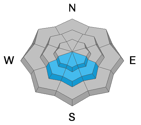
Today with increased winds and continued snowfall, the avalanche danger is CONSIDERABLE on upper elevation slopes which should have fresh drifts from westerly winds.
Mid elevations are less likely to be loaded by winds and have a MODERATE danger. Low elevations have less snow and less wind and a LOW danger.
Low
Moderate
Considerable
High
Extreme
Learn how to read the forecast here
Special Announcements
Get discount lift tickets HERE. Thanks for this generous support from Utah Ski Resorts and Ski Utah. All proceeds go directly to supporting the UAC.
Weather and Snow
Since yesterday morning another 4-7 inches of very light snow fell. Storm totals over the weekend are variable across the Provo area mountains with some locations barely getting any snow while other places have gotten nearly 2 feet of new snow.
Temperatures remain cold and are in the high teens and low 20s F this morning. Winds have increased since yesterday with gust about 10-15 mph higher. At ridgetops they are averaging 15 mph with gusts 20-30 mph from the WSW.
Today a cold front will descend over northern Utah and high temperatures will struggle to climb into the mid and upper 20s F. Wind speeds should continue at similar speeds. As the cold front passes, winds will briefly switch to the WNW before switching back to the WSW this afternoon. Snow will fall today with the heaviest snow this morning. By end of today about 2-4 inches should fall.
Riding and turning conditions are about as good as it gets.
Recent Avalanches
No avalanches have been reported in the Provo area mountains.
A notable avalanche occurred mid-morning in Little Cottonwood Canyon while the road was open. This slide occurred in the White Pine slide path and pushed a car off the road. Several things are notable about this slide. The path was shot with howitzer rounds before yet still produced an avalanche. UDOT shot the area with more howitzer rounds after the slide and didn't trigger any slides.
The take away is that even 105mm howitzer rounds are no guarantee, and there is always a certain amount of uncertainty when this much snow is falling. For us recreating the backcountry, we should give ourselves a wide margin of safety.
Click HERE for a list of all observations.
Ad
Avalanche Problem #1
Wind Drifted Snow
Type
Location
Likelihood
Size
Description
The main things to watch for today are soft slabs of wind drifted snow. With winds increasing since yesterday morning, I would expect plenty of wind drifting at the highest elevations. Look for signs of recent wind drifting from both WSW and WNW winds.
The good news is that many low and mid-elevation slopes exist that do not have any wind loading and just have amazing powder.
Below is a video showing winds transporting snow yesterday.
Avalanche Problem #2
New Snow
Type
Location
Likelihood
Size
Description
Some places in the Provo area mountains have received nearly 2 feet of very light snow which should sluff very easily. These can easily bury a person if they run into terrain traps like creeks or gullies. Be cautious of what is above you and where you might go if carried in one of these slides. I don't expect many soft slab avalanches in the new snow on slopes not touched by the wind.
Avalanche Problem #3
Persistent Weak Layer
Type
Location
Likelihood
Size
Description
Slopes that face southeast, south and southwest at the mid and upper elevations have a buried ice crust with a weak layer next to it that formed just before New Year's. This layer produced many human triggered avalanches after the New Year's storm. This layer should be gaining strength and may no pose a problem in the near future; HOWEVER, snowfall last week and this weekend has added a decent load of snow. With stress on this layer, I would not trust it for now. The best strategy is to avoid steep southerly facing slopes above 8000 feet. You can ride these slopes but simply choose ones less than 30 degrees in steepness
See additional information on a weak layer we have been finding on northerly aspects.
Additional Information
Northerly aspects: We continually have found a weak layer 2-3 feet deep on most other aspects besides south that is not associated with an ice crust. We've found it in Mineral Fork, Meadow Chutes. and Bountiful. Currently, it's producing spotty results (propagation) in our snowpit tests but we are yet to see any avalanche activity on this layer. We are mentioning this layer to keep you informed of what we are finding. It hasn't shown any other signs of instability, but with continued snowfall there's a chance this layer could come to life or it could simply get buried and go away. Stay tuned.
For now, after you have made all your assessments and determined it is a good idea to ride steep terrain on the north half of the compass, do a quick Extended Column Test as a last check. If it fractures across the entire column consider that a bad sign and choose a low angle slope.
General Announcements
This information does not apply to developed ski areas or highways where avalanche control is normally done. This forecast is from the U.S.D.A. Forest Service, which is solely responsible for its content. This forecast describes general avalanche conditions and local variations always occur.