Forecast for the Provo Area Mountains

Drew Hardesty
Issued by Drew Hardesty on
Tuesday morning, January 14, 2020
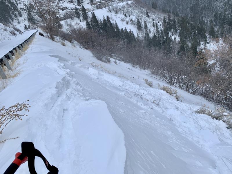
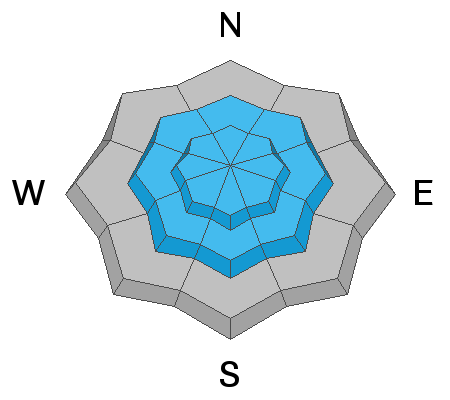
A CONSIDERABLE danger exists at the mid and upper elevations on steep wind drifted slopes. Natural avalanches may be possible today, particularly with natural cornice release. Human triggered avalanches are expected. They'll be most prominent on north to east to south facing slopes but scattered across the compass.
Some avalanches may step down into older weaker layers that have been dormant for some time. Also note that areas of MODERATE for wind drifts exist even at the low elevations.
Sluffing and fresh wind drifts are expected with the midday storm.
Low
Moderate
Considerable
High
Extreme
Learn how to read the forecast here
Special Announcements
Get discount lift tickets HERE. Thanks for this generous support from Utah Ski Resorts and Ski Utah. All proceeds go directly to supporting the UAC.
Weather and Snow
Skies are partly cloudy with warm and windy conditions overnight. The Provo mountains picked up a trace to two inches overnight with 7" since the weekend.
Temps have steadily risen and are currently in the mid to upper 20s. The west to southwest winds continue to be the punisher, averaging 15-20mph with gusts to 45. One gust at 11,000' hit 90mph overnight. It's also important to note that winds continue to be moderate to strong in the mid-elevations...and even gusty down low. Winds have stripped many west and southerly aspects down to week-old crusts..
Today we'll see increasing clouds and snow filling in during the day with 2-5" possible. Winds will remain moderate to strong from the west.
Recent Avalanches
"Tons of transport". Ski area control teams triggered numerous wind slabs yesterday. We pulled the plug in the Provo mountains yesterday from the wind. On the way back to Pine Hollow (AF), stepped over a guardrail to trigger a 6-8"x40' wind slab at 6700' while heading back to the car. See observation. The afternoon clearing and sun initiated some wet loose rollerballs and sluffs at the low elevations.
Ad
Avalanche Problem #1
Wind Drifted Snow
Type
Location
Likelihood
Size
Description
Wind slabs are scattered across the compass and can be triggered on steep terrain. Some may run naturally today.
NOTE that they will be found on nearly all aspects and even at the lowest elevations. I may have triggered my lowest elevation avalanche yesterday in Provo on a steep wind loaded south facing test slope at 6700'.
NOTE that these wind drifts may be sensitive and triggered from a distance...and/or they may be stubborn and resist failure until the 3rd skier or rider moves over them. They'll also be found well off the ridgelines and mid slope.
CRACKING AND COLLAPSING are key clues to instability.

CORNICES are becoming unruly and will break back farther than expected....and today are likely to trigger wind slabs on steep slopes below.
Avalanche Problem #2
Persistent Weak Layer
Type
Location
Likelihood
Size
Description
Two Issues That Warrant Caution:
ONE: A poor facet/crust combination exists on steep southeast to southwest facing slopes at the mid and upper elevations. These have become increasingly dormant but cannot be written off, particularly with the recent wind and snow.
TWO: I am increasingly worried about the return of the repeater avalanches - the ones that broke down to the early season persistent weak layers. Alta ski area triggered one of these with explosives on Friday...and the recent avalanches along the Park City ridgeline and Reynolds Peak looks suspiciously like they stepped into the old snow layering. I have found areas of excessively weak layers of facets and crusts in thinner areas and may be overloaded in localized terrain today.
Bottom Line: there is some potential for persistent weak layers to reawaken today 1-3' deep on nearly all aspects of the mid and upper elevations.
UNCERTAINTY LEVEL: HIGH
General Announcements
This information does not apply to developed ski areas or highways where avalanche control is normally done. This forecast is from the U.S.D.A. Forest Service, which is solely responsible for its content. This forecast describes general avalanche conditions and local variations always occur.