Forecast for the Provo Area Mountains

Trent Meisenheimer
Issued by Trent Meisenheimer on
Sunday morning, January 12, 2020
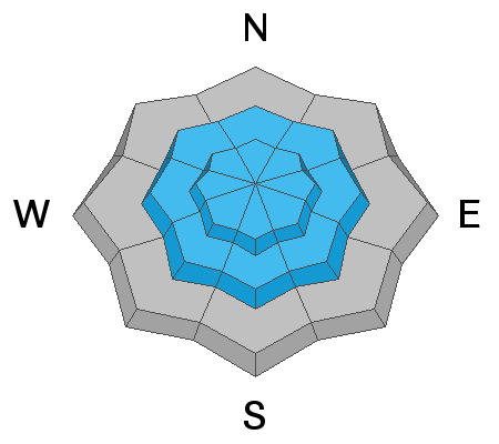
We have a CONSIDERABLE avalanche danger on all steep mid and upper elevation slopes for triggering three different types of avalanches (read below for each of these avalanche problems). Dangerous avalanche conditions. Careful snowpack evaluation, cautious route-finding and conservative decision-making will be essential today. Natural avalanches are possible and human triggered avalanches are likely. At mid elevations you will find a MODERATE danger. Low elevations have a LOW avalanche danger.
Low
Moderate
Considerable
High
Extreme
Learn how to read the forecast here
Special Announcements
Get discount lift tickets HERE. Thanks for this generous support from Utah Ski Resorts and Ski Utah. All proceeds go directly to supporting the UAC.
New to the backcountry or in need of a refresher? Consider taking a companion rescue course offered at Woodward Park City, January 14, 5:30-9 p.m.
Be sure to catch up on what happened this past week. Greg Gagne put together our "Week In Review" found HERE
Weather and Snow
As the storm exits this morning we will continue to see snow showers into the early morning before it tapers off. Mountain temperatures are in the teens °F at upper elevations and hovering in the mid to low 20's °F at lower elevation trailheads. The westerly winds did chill out in the overnight hours and are currently blowing 5-10 mph with gusts into the 20's in exposed terrain. In the past 24 hrs the Provo range picked up 4"-8" of new snow containing 0.10"-0.36" of water. In places like American Fork and the closer to the Cottonwoods will have significantly more snow and in the range of 12-24" with 0.63-1.50" of water.
This afternoon we have one last wave coming through the mountains that will bring 2-4" of new snow on a southwest flow. Winds are not expected to increase. Later this evening a stronger storm will move into the area and we can expect another 6-12" of new snow by Monday afternoon. It looks to be a very snowy week with another storm on tap Tuesday followed by a stronger and more organized system on Thursday. Bring it!
Riding and turning conditions are all time with blower powder on all aspects and elevations.
Recent Avalanches
No new observations came in from the Provo area. Around midnight the new snow started to avalanche naturally on the steep southerly facing slopes in Little Cottonwood Canyon. Little Pine Chute avalanched naturally in the overnight hours and was large enough to cross and cover the CLOSED highway in avalanche debris. One observation from the Bountiful area showed wind slab avalanches that were 12-16" deep 30-40' feet wide running 500' vertical feet downhill. Click HERE for a list of all observations.
Ad
Avalanche Problem #1
Wind Drifted Snow
Type
Location
Likelihood
Size
Description
Yesterday the westerly winds blew steady across the upper elevation ridgelines with speeds of 10-15 mph gusting into the 20's and 30's. Today those winds have slowed and are currently blowing 5-15 mph with gusts into the low 20's. With so much snow available for transport you can expect wind drifted snow avalanches. The bad news, is that any new drift from yesterday will be covered and hidden by the new snow.
Wind Drifted Snow is often highly variable, but, it's typically found on leeward slopes, in gullies, bowls, and near distinct changes in slope angle. Often it looks rounded, wavy, and pillowy. These soft slabs will be large enough to catch, carry, or bury a person. Shooting cracks are an obvious clue to unstable snow. Cautious route-finding and conservative decision-making will be essential today.
Avalanche Problem #2
New Snow
Type
Location
Likelihood
Size
Description
In the past 24 hrs we've received 4"-8" inches of new snow. In some areas closer to the Cottonwoods the new snow might be closer to 12"-24". You can expect the new snow to produce soft slab avalanches failing within the storm snow as well as dry loose avalanches that will be easy to initiate in steep terrain. I am unsure just how touchy the new snow will be today. However, think about the terrain you're in and if you're wrong about the stability where do you end up? places like terrain traps, and gullies will only increase the odds of being buried deep. Use small test slopes and shovel tilt tests to see how the new snow is reacting.
Avalanche Problem #3
Persistent Weak Layer
Type
Location
Likelihood
Size
Description
South aspects: On aspects that face southeast, south and southwest at the mid and upper elevations you can find a poor snowpack structure. Here you will find an ice crust with weak snow above and below the crust. Many human triggered slides happened as a result of this set up. It's been about a week since we've seen activity on this layer. However, in the past 4 days we have loaded this layer with 20"-50" of snow containing 1.7"-2.65" inches of water weight. This is a huge load to the snowpack and for today these aspects and elevations should not be trusted.
  • See additional information on a weak layer we have been finding on northerly aspects.
Additional Information
Northerly aspects: On Friday, I dug four snowpits in Mineral Fork on elevations from 7,800' to 9,300' and consistently found a weak layer of snow buried roughly 2-3' deep in the snowpack. I found this layer on slopes that faced northeast, north and east. In my snowpit tests I was able to propagate a crack across the column and to me this says I could trigger an avalanche as a result. I am not the only one finding this layer. Yesterday, professional guides also found this layer. Drew Hardesty found it in the Meadow Chutes. Mark Staples found it in Bountiful. Currently, it's producing spotty results (propagation) in our snowpit tests but we are yet to see any avalanche activity on this layer. It's worth noting and remembering this layer for now.
General Announcements
This information does not apply to developed ski areas or highways where avalanche control is normally done. This forecast is from the U.S.D.A. Forest Service, which is solely responsible for its content. This forecast describes general avalanche conditions and local variations always occur.