


Forecast for the Moab Area Mountains

Issued by Eric Trenbeath on
Saturday morning, December 28, 2019
Saturday morning, December 28, 2019
The avalanche danger remains CONSIDERABLE and human triggered avalanches are likely on steep, upper elevation, wind drifted slopes. Avoid steep slopes with recent deposits of wind drifted snow. Human triggered avalanches within the storm snow are also possible and the danger is MODERATE for this type of avalanche on steep slopes on all aspects at mid and upper elevations. And finally, a triggered wind drift, or storm snow avalanche may have the potential to step down into a buried, persistent weak layer causing a deeper and more dangerous avalanche. Be conservative in your terrain selection today and allow the new snow to settle in and adjust.

Low
Moderate
Considerable
High
Extreme
Learn how to read the forecast here
 Special Announcements
Road Conditions: Grand County will not be plowing until Monday. They have not plowed since the Christmas Eve storm and up to a foot of snow has fallen at the trailhead since then. Numerous vehicles have made it up every day but conditions are getting continually worse. 4x4 with good tires and or chains are required.
Grooming update: Powder snow will cover the trails today.
 Weather and Snow
24 Hour Snow 6" Weekly Snow 24" Base Depth in Gold Basin 48" Wind NW 0-5 mph Temp 11F
Another 6" of snow has fallen since yesterday morning bringing storm totals up to 12". More than 2' of snow has fallen since Christmas Eve. SE winds yesterday cranked in the 25-30 mph range with gusts in the 40's before abruptly dropping off and shifting to the SW yesterday afternoon. Overnight they shifted to the WNW, barely blowing in the single digits.
Today look for lingering snow showers under mostly cloudy skies. 1"-2" are possible. WNW winds will be on the increase reaching 20-30 mph along ridge tops by this afternoon. Daytime highs will be in the low teens with a wind chill factor of -15. Dry and cold NW flow will persist into mid-week.
I didn't receive any reports from the backcountry yesterday and I'm afraid I've been out under the weather. Needless to say, there is powder out there!
Wind, temperature, humidity on Pre Laurel Peak (11,700')
Storm totals at Gold Basin Study Plot (10,000').
Snotel site near Geyser Pass Trailhead (9600').
NWS weather forecast.
 Recent Avalanches
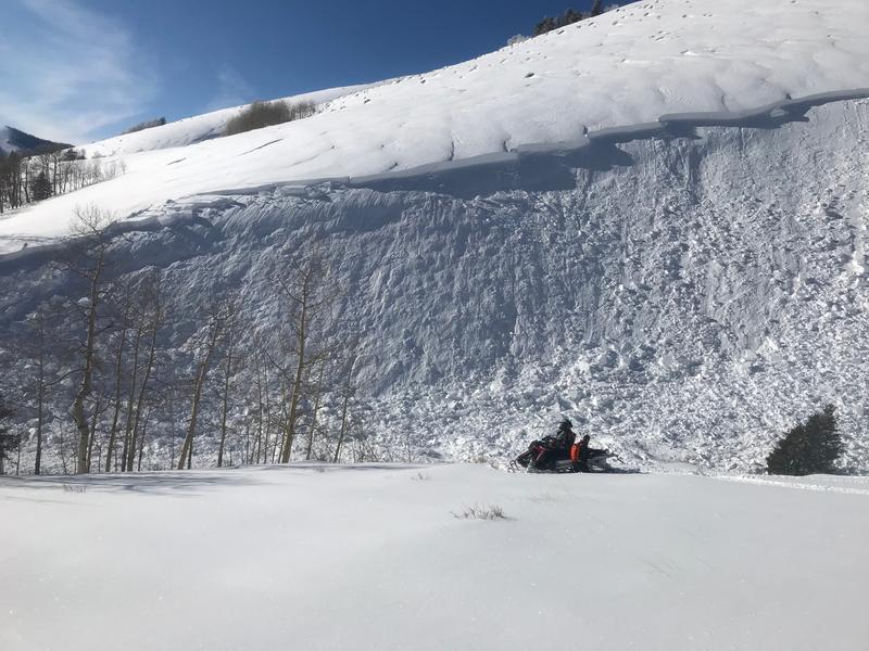
A snowmobiler triggered a large avalanche in the Abajo Mountains on Thursday. Details are scant at this time but he apparently took a ride and deployed his airbag. This photo just shows a small portion of the slide.
Numerous, long-running sluffs, and at least one wind slab avalanche were observed in the high country on Thursday. Check out this observation from Travis Nauman for more details.
A snowboarder in Dutch Draw, outside of the Canyons Resort, unknowingly triggered an avalanche in the storm snow on Christmas Day that could have buried him. Storm snow instabilities typically settle out after a day or two, but with 24" or more of new snow in the high country, you'll want to stay alert to this type of avalanche problem today. Thanks to Matt Baydala for the footage, and glad everything turned out ok.

Avalanche Problem #1
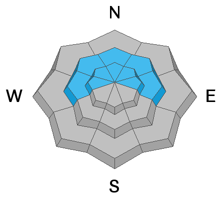
Wind Drifted Snow
Type
Location

Likelihood
Size
Description
More than 2' of snow, combined with moderate to strong winds have formed deep drifts on the leeward sides of ridge crests and terrain features, primarily in upper elevation terrain. With a forecast for increasing NW winds today, you will want to be on the lookout for fresh drifts to form on slopes facing the S side of the compass. Wind drifts are recognizable by their smooth, rounded appearance and cracking is a sign of instability. Avoid steep slopes that have recent deposits of wind drifted snow.
Avalanche Problem #2
New Snow
Type
Location

Likelihood
Size
Description
More than 2' of new snow has fallen at upper elevations since Christmas Eve, with a foot of new snow since early Friday morning. Human triggered avalanches involving the new snow are possible on steep slopes on all aspects. New snow avalanches can occur as loose snow sluffs, or as cohesive soft slabs. Instabilities within the new snow typically settle out after a day or two but it is important to let the snow adjust. Utilize test slopes to see how the new snow is behaving before committing to larger terrain.
Avalanche Problem #3
Persistent Weak Layer
Type
Location
Likelihood
Size
Description
Weak layers have been observed developing within the snowpack over the past week to 10 days. I'm uncertain to what extent the new snow has, or will affect them, but a triggered wind drift, or new snow avalanche has the potential to step down into a buried weak layer. The only way to know for sure at this point will be to dig and perform your own stability analysis at this point. We'll be trying to gather as much information as possible about this potential problem over the next few days. For now, the travel advice remains largely the same - avoid steep, wind drifted slopes that face the north half of the compass.
General Announcements
Get one of these cool t-shirts to support the UAC and other avalanche centers across the U.S.
This forecast is from the U.S. Forest Service, which is solely responsible for its content. This forecast describes general avalanche conditions and local variations always occur.