Forecast for the Moab Area Mountains

Eric Trenbeath
Issued by Eric Trenbeath on
Sunday morning, December 29, 2019
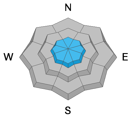
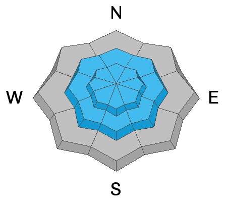
The avalanche danger remains CONSIDERABLE and human triggered avalanches are likely on steep, upper elevation, wind drifted slopes. Avoid steep slopes with recent deposits of wind drifted snow. Human triggered avalanches within the storm snow are also possible and the danger is MODERATE for this type of avalanche on steep slopes on all aspects at mid and upper elevations. And finally, a triggered wind drift, or storm snow avalanche may have the potential to step down into a buried, persistent weak layer causing a deeper and more dangerous avalanche. Be conservative in your terrain selection today and allow the new snow to settle in and adjust.
Low
Moderate
Considerable
High
Extreme
Learn how to read the forecast here
Special Announcements
Road Conditions: Grand County plowed up to the Geyser Pass trailhead yesterday.
Grooming update: Powder snow will cover the trails today.
Weather and Snow
24 Hour Snow 0" Weekly Snow 24" Base Depth in Gold Basin 48" Wind NW20 G30 mph Temp -4F
Skies are clear, northerly winds are on the increase, and temps are below zero. Yesterday's forecasted NW winds never materialized and conditions were calm most of the day. Unfortunately, they have been on the increase since 0500 this morning and we should see them blowing in the 20-25 mph range along ridge tops. Skies should be mostly clear, and high temps will be around 10 degrees. We'll see cold dry air for the next few days before an active pattern kicks in again around the New Year.
After a mostly dry December, storms during Christmas week delivered bringing 2' of much-needed snow to the mountains. Backcountry observers are reporting excellent riding and turning conditions but signs of instability such as cracking and collapsing in the snowpack remain present. Remain conservative in your terrain choices and allow the snowpack to adjust to the recent load. For more info check out this observation from Reed Kennard and company who were out yesterday. Aimee Barnes was out on Friday and sent in this observation.
Wind, temperature, humidity on Pre Laurel Peak (11,700')
Storm totals at Gold Basin Study Plot (10,000').
Snotel site near Geyser Pass Trailhead (9600').
NWS weather forecast.
Recent Avalanches
A snowmobiler triggered a large avalanche in the Abajo Mountains on Thursday. Details are scant at this time but he apparently took a ride and deployed his airbag. This photo shows just a small portion of the slide which extends to the right and up along the ridge crest for several hundred feet. Note the telltale signs if wind drifted snow above the fracture line.
Ad
Avalanche Problem #1
Wind Drifted Snow
Type
Location
Likelihood
Size
Description
More than 2' of snow, combined with moderate to strong winds have formed deep drifts on the leeward sides of ridge crests and terrain features, primarily in upper elevation terrain. With a forecast for increasing northerly winds today, you will want to be on the lookout for fresh drifts to form on slopes facing the S side of the compass. Wind drifts are recognizable by their smooth, rounded appearance and cracking is a sign of instability. Avoid steep slopes that have recent deposits of wind drifted snow.
Avalanche Problem #2
New Snow
Type
Location
Likelihood
Size
Description
More than 2' of new snow has fallen at upper elevations since Christmas Eve, with a foot of new snow since early Friday morning. Human triggered avalanches involving the new snow remain possible on steep slopes on all aspects. New snow avalanches can occur as loose snow sluffs, or as cohesive soft slabs. Instabilities within the new snow typically settle out after a day or two but it is important to let the snow adjust. Utilize test slopes to see how the new snow is behaving before committing to larger terrain.
Avalanche Problem #3
Persistent Weak Layer
Type
Location
Likelihood
Size
Description
Stability tests from observers have shown a reactive weak layer at the interface between the Christmas Eve storm and the old snow surface. Additionally, weak layers have been observed developing within the snowpack over the past week to 10 days. A triggered wind drift, or new snow avalanche has the potential to step down into a buried weak layer causing a deeper and more dangerous avalanche. I don't currently have a very good handle on how widespread this problem is, but you are most likely to encounter persistent weak layers on shady slopes that face the north half of the compass.
General Announcements
Get one of these cool t-shirts to support the UAC and other avalanche centers across the U.S.
This forecast is from the U.S. Forest Service, which is solely responsible for its content. This forecast describes general avalanche conditions and local variations always occur.