UDOT PLANNED AVALANCHE CLOSURES!!

Forecast for the Uintas Area Mountains

Craig Gordon
Issued by Craig Gordon on
Saturday morning, January 11, 2025
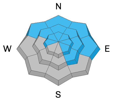
Fresh storm snow conspires with some rowdy winds, creating CONSIDERABLE avalanche danger on all aspects at and above treeline, especially in the high alpine windzone. Human triggered wind drifts are LIKELY around the dial and any slide triggered may break deeper and wider than you might, especially on slopes facing the north half of the compass. While pockety and becoming harder to initiate, avalanches failing to old snow may produce a slide breaking 2'-4' deep and hundreds of feet wide.
Mid elevation terrain offers MODERATE avalanche danger. Human triggered avalanches are POSSIBLE on steep, wind drifted slopes.
It'll be rugged out there today, so why not head to wind sheltered, lower elevation terrain, where you'll find quality riding and LOW avy danger in around the compass.
Low
Moderate
Considerable
High
Extreme
Learn how to read the forecast here
Special Announcements
Receive forecast region-specific text message alerts to receive messages about changing avalanche conditions, watches, and warnings. Sign up and update your preferences HERE.
Weather and Snow
Nowcast - Under mostly cloudy skies, light snow started falling right around 01:00. It's a North Slope kinda storm with an evenly distributed 5" of snow and .40 H2O from Trial Lake northward. The south half of the range didn't get invited to this party and storm totals are about half as much. As is much of the case this winter, the headline news are the winds. West and southwest winds blowing in the 30's and 40's take center stage while temperatures register in the teens and low 20's. The snow surface is hit or miss as recent winds have worked much of our open terrain. But with more snow headed our way, perhaps a leisurely start is the ticket. Maybe think about getting some chores done right out of the gates and let a little more snow stack up. I bet a late morning jaunt into mid elevation wind sheltered terrain will yield a solid ROI for your efforts.
Forecast- Look for mostly cloudy skies with one last gasp of snowfall sliding through our area in the next few hours, though I think this storm is a bit of a bust. However, I'm cautiously optimistic we'll squeeze 4"-6" of snow out of this system before clouds begin thinning late in the day. A cold front slides through the Uinta zone later this morning and winds switch to the west and northwest yet remain obnoxious, blowing in the 40's near the high peaks. It'll feel like winter with temperatures hovering in the teens and low 20's. Overnight lows crater into the single digits under clearing skies.
Futurecast- A stray snow shower of two may linger into Sunday, but I'm thinking it'll be a glorious day in the mountains with mostly sunny skies and crisp temperatures. Looking into the weather forecast crystal ball... we're high and dry through the upcoming work week.
Current Conditions-
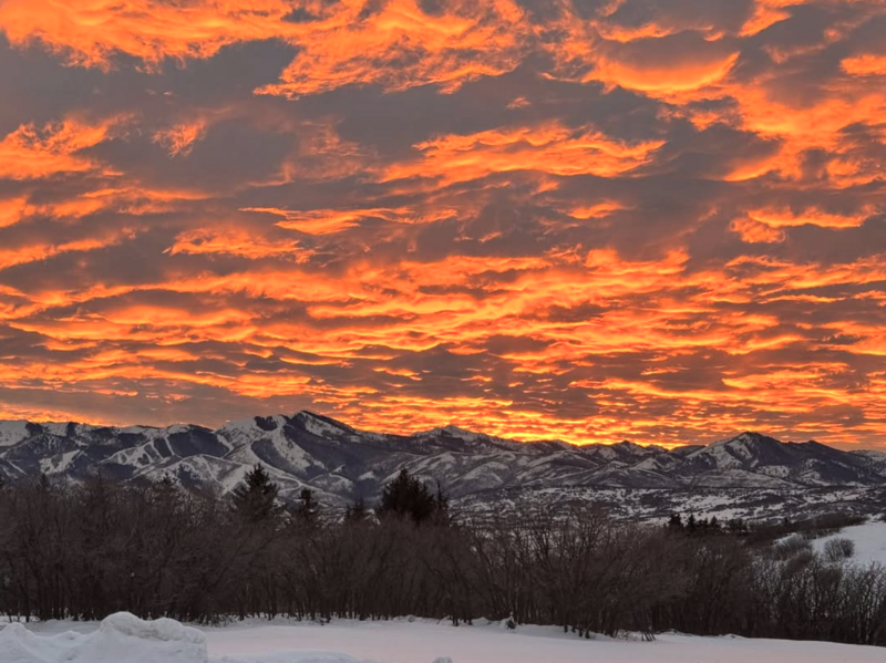
I know you came for the snow, but you should stick around for the sunsets... they're pretty special too. Thanks Katie for the stunning image.
All Uinta obs and trip reports can be found here.
Recent Avalanches
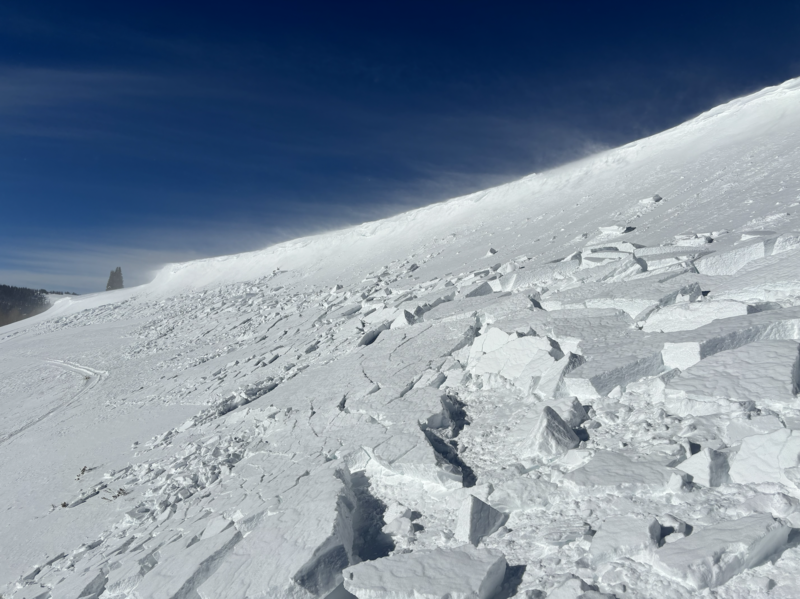
Andy found yesterday's fresh drifts on the leeward side ridges, rather touchy, though predictably reactive to his additional weight.
All Uinta obs and trip reports can be found here.
Ad
Avalanche Problem #1
Persistent Weak Layer
Type
Location
Likelihood
Size
Description
Above is a midweek ob from Weber Canyon, illustrating a strengthening snowpack and a stubborn slab and that's good news.
But wait... there's more! Local snow-pro Ted Scroggin nailed it in yesterday's ob from the Whitney Basin zone, stating... "Felt like a status quo day with no big red flags, but the snowpack structure is still priority." And that's the tricky part of making the sausage. As we see fewer avalanches and less obvious signs of instability (cracking, collapsing, or whumphing sounds), it may seem like the weak layer is happy in it's own skin or at least dormant for the moment, but there's still a likely chance of triggering a large avalanche.
So... how am I managing this avalanche dragon? I'm steering clear of avalanche terrain on the north half of the compass, opting for lower angle, wind sheltered slopes and still having a blast. Hmm, seems like a good business model... I'll take it!
Avalanche Problem #2
Wind Drifted Snow
Type
Location
Likelihood
Size
Description
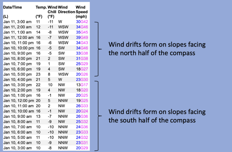
A 24 hour wind run from Windy Peak (10, 661') illustrates winds from every direction, somewhat complicating loading patterns and slab distribution, especially above treeline in the windzone.
Winds have been all over the map the past 24 hours, forming drifts in likely suspect terrain like on the leeward side of ridges and around terrain features like chutes and gullies. However, with the strength of overnight winds, I wouldn't be too surprised to find drifts lower down-slope than we might anticipate. And while recent drifting has been pretty straightforward, now with some storm snow to work with, I expect today's drifts could surprise you and pack more punch, breaking a little wider and deeper than you might expect. I'm looking for a good day of riding and avoiding rounded, pillows of snow that may sound hollow like a drum. You know the drill... lose the wind and you lose the problem... and get great riding to boot!
General Announcements
The Uinta weather station network was upgraded this summer and all that real-time info is found here. Simply click on the "Western Uinta" tab and then the "Weather Stations" tab to find all your weather needs.
We are always looking for snow and avalanche observations or just general riding conditions. So... if you see something, say something. You can reach our team directly by contacting: Craig at craig@utahavalanchecenter.org, 801-231-2170, or Andrew at andy@utahavalanchecenter.org, or 860-460-8142.
General Information
This forecast is from the U.S.D.A. Forest Service, which is solely responsible for its content. This forecast describes general avalanche conditions and local variations always occur. This forecast was issued on Saturday, January 11th at 04:00AM and expires 24 hours after it was issued. We will update the forecast by 0700 AM tomorrow. But, in the meantime reach out to us with questions, or if you see anything in your travels.