Forecast for the Skyline Area Mountains

Brett Kobernik
Issued by Brett Kobernik on
Monday morning, March 22, 2021
The avalanche danger is MODERATE today above 8000' in elevation.
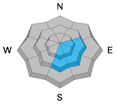
Watch for wet avalanche activity this morning on east and south facing slopes.
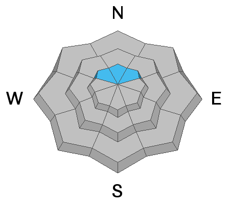
Keep in mind that there is still weak snow near the ground and it's possible that a person could trigger an avalanche that breaks into this stuff. Most likely spots would be upper elevation northerly facing steep slopes where the snowpack is shallow, four feet deep or less.
Low
Moderate
Considerable
High
Extreme
Learn how to read the forecast here
Special Announcements
Spring Awareness Campaign - Help us save lives through avalanche forecasts and education. Consider making a donation to show your support. DETAILS HERE.
Weather and Snow
Current Conditions: We squeaked out a few more inches of snow than I expected during the day on Monday. About 5 inches fell during the day. This brings totals up to about a foot since Saturday. The brunt of the snow fell in the mid portion of the Skyline from around Pleasant Creek down to Manti Canyon. You'll only find about 6 inches or so north and south of there. Skies are clear and temperatures are in the low teens. Northwest wind is pretty light.
Mountain Weather: We'll have clear skies this morning with clouds building in this afternoon. Temperatures should get into the mid to upper 20s. Northwest wind should remain light to moderate in speed. Another storm system will move through tonight and Tuesday bringing 6 to 10 inches of new snow. Another storm is shaping up for late Thursday that should bring a few more inches of snow.
Ad
Avalanche Problem #1
Wet Snow
Type
Location
Likelihood
Size
Description
The most likely avalanche problem you'll see today will be wet avalanche activity within the new snow. This probably won't pose much threat to people unless you are sitting in a confined place like in a steep gully or ravine with a large steep slope above you. Roller balls or pinwheels often start to come down before the snow gets really unstable. East and south facing slopes are the most likely to become wet to the point of being unstable. Clouds should move in this afternoon before west facing slopes heat up too much.
The central portion of the Skyline that received the most snow is where this actually might be an issue to watch out for.
Avalanche Problem #2
Persistent Weak Layer
Type
Location
Likelihood
Size
Description
Triggering an avalanche that breaks into weak snow near the ground is still a concern but the chances are getting pretty slim as warm spring weather helps consolidate the mid and upper layers of the snowpack. However, the weight from the recent storm will stress the snowpack to a certain extent. This was not a huge load so I really don't think it will make that much difference but continue to pay attention if you experience any collapsing or "whoomping" of the snowpack. This is a sure sign that you are in an areas with unstable snow.