Forecast for the Skyline Area Mountains

Brett Kobernik
Issued by Brett Kobernik on
Saturday morning, February 20, 2021
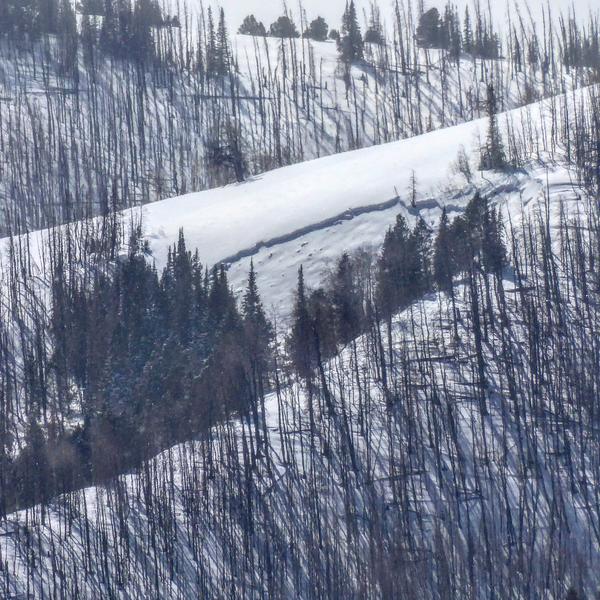
THE AVALANCHE DANGER REMAINS HIGH TODAY!!
Human triggered avalanches are almost certain.
AVOID BEING ON OR BELOW ANY STEEP SLOPE.
PLACES YOU USUALLY TRAVEL MAY NOT BE SAFE!
Low
Moderate
Considerable
High
Extreme
Learn how to read the forecast here
Weather and Snow
Current Conditions: Up to 2" of snow accumulated on Friday during a few hours of light snowfall. Temperatures pushed into the upper 20s durning the day and are now in the low 20s. The southwest wind is pretty breezy along the higher peaks. There was a gust of 50mph recorded overnight on Monument Peak. It doesn't look so breezy down off the ridgelines.
Mountain Weather: We have another weak system moving through today that should bring a shot of snow. As of this morning, snow amounts look smaller compared to how they looked yesterday. I'd say totals will be a few inches at best. Southwest wind will make a quick change to the northwest as the storm hits mid day. It looks like they'll slow a bit as they shift to the northwest. Temperatures will remain in the low 20s.
Recent Avalanches
More avalanche activity was reported yesterday. Scott Stevens of Diamond S reported that on Thursday his group was taking a lunch break and watched an avalanche release some 200 to 300 yards away from them. He noted a number of other avalanches that he saw as well.
I found more natural avalanches that released during the natural avalanche cycle on Wednesday. These were all visible from the Miller Flat/Joe's Valley groomed snowmobile trail. Check out the complete AVALANCHE LIST HERE.
Photo below: Natural between Bennetts and Booths
Photo below: between Fly and Mill canyons
Ad
Avalanche Problem #1
Persistent Weak Layer
Type
Location
Likelihood
Size
Description
The weak snow near the ground is now buried with numerous layers of newer snow. This weak foundation will continue to collapse and cause avalanches.
The natural avalanche cycle on Wednesday was fairly widespread across the range but my opinion is that there were not a huge amount of avalanches. That means that many MANY slopes are holding the new load that sits on the incredibly weak base layers of loose sugar. These slopes are poised to avalanche. Don't screw around with them.
At this point in the season, there is a good chance that basal layers of faceted snow will never completely stabilize and we may be dealing with it the entire winter.