

Forecast for the Skyline Area Mountains

Issued by Brett Kobernik on
Wednesday morning, February 19, 2025
Wednesday morning, February 19, 2025
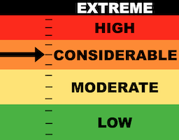
The avalanche danger on the Skyline is CONSIDERABLE today.
Human triggered avalanches are again likely today.
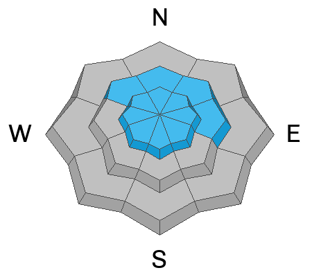
Continue to avoid steep slopes especially those that have been wind loaded that face northeast, east and southeast.

Low
Moderate
Considerable
High
Extreme
Learn how to read the forecast here
 Special Announcements
Help the University of Utah understand risk behavior in the backcountry by participating in a 15-minute survey. The U will compensate up to $30 for your time! Please note: responses will not be confidential but will be handled ethically under IRB guidelines.
 Weather and Snow
Current Conditions: A few flakes fell over the last 24 hours not really adding up to anything. Temperatures reached the mid 20s on Tuesday and dropped back into the teens overnight. Wind was in the moderate speed category again all day Tuesday but slowed overnight. All I can give the riding conditions is an OK rating. You can find some good snow. You can find some bad snow.
Mountain Weather: Expect clouds to roll in late morning or early afternoon. Wind will be light from the west southwest. Temperatures are going to warm into the upper 20s or low 30s. Thursday's expected small storm is actually looking a little better to me this morning. We could squeak out 3 to 6 inches of new snow. Hopefully that's the case because it looks like a period of high pressure starts to build in this weekend lasting well into next week.

Avalanche Problem #1
Wind Drifted Snow
Type
Location
Likelihood
Size
Description
No big change in avalanche conditions from Tuesday. Wind drifted snow remains the main focus. Fresh drifts and slabs may break within the upper layers of the most recent storm snow. There was an inversion in the top two layers of snow that was failing and producing avalanches over the previous weekend. This issue should be settling out and stabilizing. However, we saw more wind yesterday which drifted more snow which added more stress. So, the deal for today is that you may trigger one of these fresh drifts or slabs if you are poking around on steep slopes.
.
Avalanche Problem #2
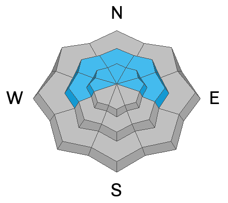
Persistent Weak Layer
Type
Location
Likelihood
Size
Description
Numerous layers of weak sugary snow plague the Skyline snowpack. I was decending through the woods on a snowbike yesterday and it was all I could do to keep the machine or me from augering into the bottomless sugar. The reason we're not seeing widespread avalanches breaking into these layers is that we just haven't gotten a significant new load of snow.
That said, areas where the wind has drifted snow are areas where you could trigger a deeper avalanche today. It's a tenuous situation. Not all slopes will release but it's almost impossible to say for certain which slopes will stay in place and which won't.
Personally, I can't try to thread the needle and analyze every steep slope to try and determine if I can get onto it. I know the snowpack is junk all over the place so I'm biding my time until I see stable conditions. I'm sticking to low angle terrain until conditions change.
General Announcements
This forecast is from the U.S.D.A. Forest Service, which is solely responsible for its content. This forecast describes general avalanche conditions and local variations always occur.