Forecast for the Skyline Area Mountains

Brett Kobernik
Issued by Brett Kobernik on
Friday morning, February 12, 2021
THE AVALANCHE DANGER IS INCREASING!!
The avalanche danger is CONSIDERABLE today. Conditions will remain dangerous through the weekend as more snow gets added to the weak snowpack. Human triggered avalanches are almost certain.
You will want to avoid being on or below any steep slope. A dangerous situation is shaping up.
Low
Moderate
Considerable
High
Extreme
Learn how to read the forecast here
Avalanche Watch
THE AVALANCHE DANGER FOR THE WARNING AREA WILL LIKELY RISE TO HIGH BY SATURDAY, AND VERY DANGEROUS AVALANCHE CONDITIONS ARE LIKELY TO CONTINUE THROUGH THE WEEKEND.
WATCH IS FOR HIGH AVALANCHE DANGER IN THE BACKCOUNTRY BEGINNING FRIDAY MORNING AND LASTING THROUGH THE WEEKEND
FOR ALL THE MOUNTAINS OF NORTHERN UTAH INCLUDING THE WASATCH RANGE...BEAR RIVER RANGE...UINTA MOUNTAINS...MANTI SKYLINE
HEAVY SNOW AND DRIFTING WILL OVERLOAD BURIED PERSISTENT WEAK LAYERS AND CREATE WIDESPREAD AREAS OF UNSTABLE SNOW. BOTH HUMAN TRIGGERED AND NATURAL AVALANCHES WILL BECOME LIKELY. STAY OFF OF AND OUT FROM UNDER SLOPES STEEPER THAN 30 DEGREES.
Special Announcements
FREE BEACON TRAINING
When: Saturday, Feb 13, 9am to 1pm
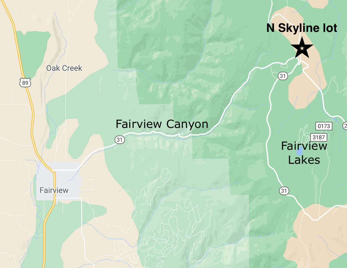
Where: North Skyline Drive parking lot at the top of Fairview Canyon.
How it works: Show up anytime between 9am and 1pm and we'll spend an hour to an hour and a half showing you how to perform an effective beacon search.
Weather and Snow
Current Conditions: Light snowfall started about midnight and a few inches have accumulated as of 6am. It looks like it contains graupel so it is higher density. Temperatures remaing pretty mild with most stations in the mid to upper 20s. Southwest wind has been a bit gusty along the higher terrain but fairly light down in the canyons and drainages.
Mountain Weather: Snow should continue this morning and taper off this afternoon. We should see a few more inches but totals look to be less than I anticipated. The north end of the Skyline should fair the best. Westerly wind will remain mostly moderate in speed and temperatures will remain in the mid 20s. The next impulse will be Saturday which is currently looking more promising for snow totals. I would say we are still on track for a foot of snow total by Sunday. Another storm will move through Monday night which currently looks good for a decent shot of snow.
Recent Avalanches
The UAC staff has completed the very complex fatal avalanche accident report from last Saturday in the Wasatch mountains. MILL CREEK - WILSON GLADE AVALANCHE REPORT
Check out the SKYLINE AVALANCHE LIST that has all the avalanche reports from earlier in the week. There are sure to be more this weekend.
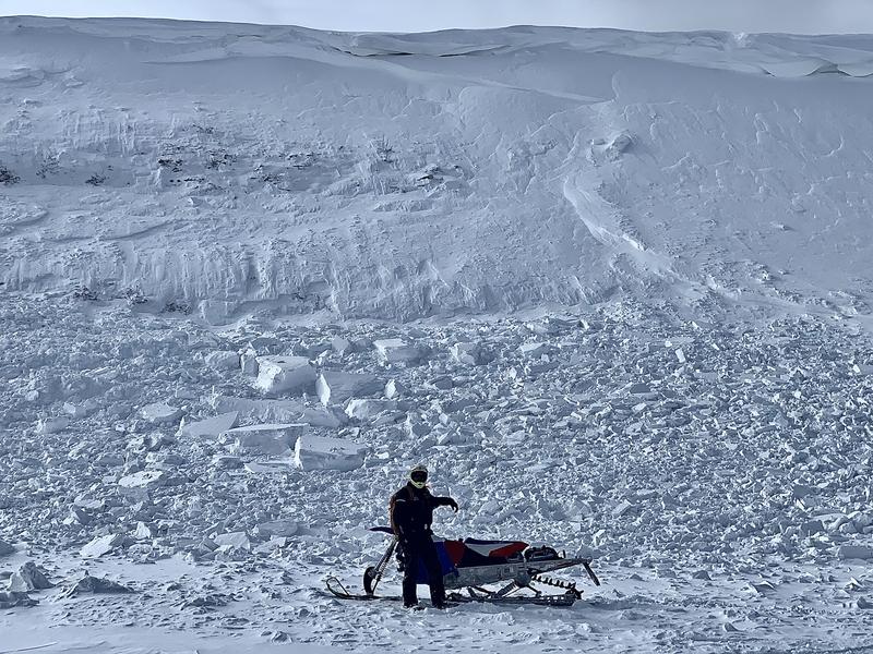
Photo: Hard slab avalanche above Jet Fox Reservoir.
You can always check out the complete avalanche list through the "Skyline Avalanches & Observations" link at the bottom of the forecast.
Ad
Avalanche Problem #1
Persistent Weak Layer
Type
Location
Likelihood
Size
Description
CONDITIONS WILL LIKELY GET DANGEROUS. We have a very pronounced Persistent Weak Layer of faceted snow at the base of our snowpack. We are starting to stack more layers on this weak foundation. We have seen human triggered and natural avalanches during and after the last few snow storms. You should anticipate that we will continue to see avalanche activity during and after the next storms.