Forecast for the Skyline Area Mountains

Brett Kobernik
Issued by Brett Kobernik on
Thursday morning, February 11, 2021
INCREASING AVALANCHE DANGER THROUGH THE WEEKEND.
The avalanche danger is CONSIDERABLE today and there may be a HIGH AVALANCHE DANGER starting Friday and lasting through the weekend if the storms deliver. Human triggered avalanches are almost certain.
You will want to avoid being on or below any steep slope. A dangerous situation is shaping up.
Low
Moderate
Considerable
High
Extreme
Learn how to read the forecast here
Avalanche Watch
THE AVALANCHE DANGER FOR THE WARNING AREA WILL LIKELY RISE TO HIGH BY FRIDAY, AND VERY DANGEROUS AVALANCHE CONDITIONS ARE LIKELY TO CONTINUE THROUGH THE WEEKEND.
WATCH IS FOR HIGH AVALANCHE DANGER IN THE BACKCOUNTRY BEGINNING FRIDAY MORNING AND LASTING THROUGH THE WEEKEND
FOR ALL THE MOUNTAINS OF NORTHERN UTAH INCLUDING THE WASATCH RANGE...BEAR RIVER RANGE...UINTA MOUNTAINS...MANTI SKYLINE
HEAVY SNOW AND DRIFTING WILL OVERLOAD BURIED PERSISTENT WEAK LAYERS AND CREATE WIDESPREAD AREAS OF UNSTABLE SNOW. BOTH HUMAN TRIGGERED AND NATURAL AVALANCHES WILL BECOME LIKELY. STAY OFF OF AND OUT FROM UNDER SLOPES STEEPER THAN 30 DEGREES.
Special Announcements
FREE BEACON TRAINING
When: Saturday, Feb 13, 9am to 1pm
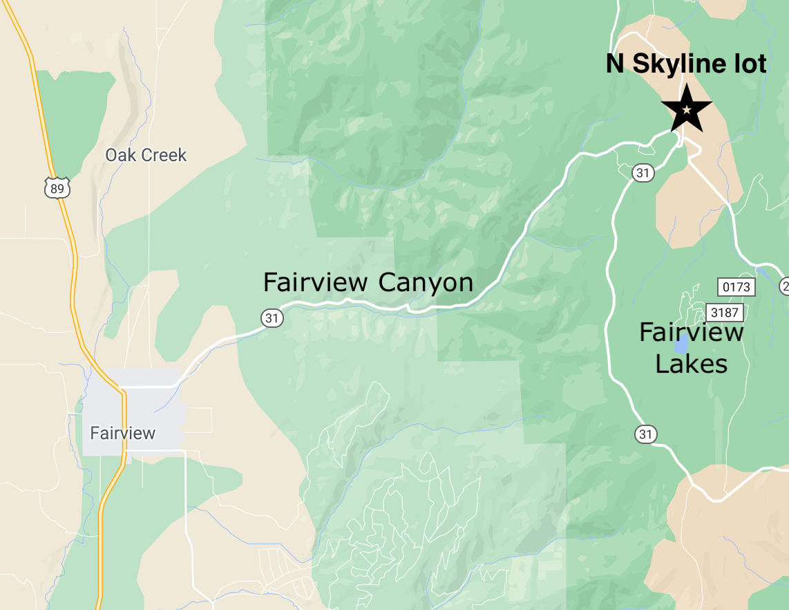
Where: North Skyline Drive parking lot at the top of Fairview Canyon.
How it works: Show up anytime between 9am and 1pm and we'll spend an hour to an hour and a half showing you how to perform an effective beacon search.
Weather and Snow
Current Conditions: Westerly wind spiked a bit overnight with a couple of hours with gusts into the 50s along the most exposed peaks. I think we've seen their max speed for the day. Temperatures remain steady in the mid 20s.
Mountain Weather: Today we'll see increasing clouds, moderate speed westerly wind and highs in the upper 20s. Weather models continue to tell us that an active wet pattern will move in through the middle of next week. The first storm moves through tonight lingering into Friday. It doesn't look real windy and temperatures remain fairly mild. Currently I'm thinking 5 to 10" by mid day Friday. Another similar impulse will move through Saturday with another good shot of snow, increasing southwest wind and temperatures dropping into Sunday. It seems possible that we could see a foot of snow total out of these two storms or more if things shake out right.
Recent Avalanches
I finally was able to finish compiling all of the avalanche reports from activity earlier in the week. I recorded 11 avalanche reports this week. At least four were snowmobile triggered with one person getting caught and carried in the upper end of The Cove. AVALANCHE LIST
Photo: 4 foot deep fracture line from The Cove
You can always check out the complete avalanche list through the "Skyline Avalanches & Observations" link at the bottom of the forecast.
Ad
Avalanche Problem #1
Persistent Weak Layer
Type
Location
Likelihood
Size
Description
CONDITIONS WILL LIKELY GET DANGEROUS. We have a very pronounced Persistent Weak Layer of faceted snow at the base of our snowpack. We are starting to stack more layers on this weak foundation. We have seen human triggered and natural avalanches during and after the last few snow storms. You should anticipate that we will continue to see avalanche activity during and after the next storms.