Forecast for the Skyline Area Mountains

Brett Kobernik
Issued by Brett Kobernik on
Friday morning, December 10, 2021
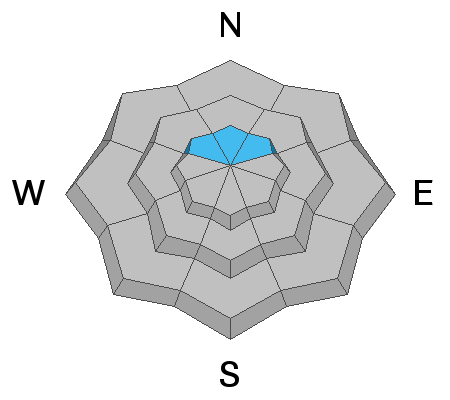
Overall, the avalanche danger is generally LOW.
There is a MODERATE danger in upper elevation northerly facing slopes that received around a foot of wind drifted snow. Small human triggered slab avalanches are possible on these slopes.
Low
Moderate
Considerable
High
Extreme
Learn how to read the forecast here
Weather and Snow
Current Conditions:
It looks like the storm produced about as expected and we may see a few more inches accumulate this morning. Snow totals are 8 to 14 inches. Many areas received a foot of snow. The storm started out warm with a southwest wind direction. The first few inches of snow should've been pretty dense. Temperatures have been in a nose dive since yesterday afternoon and are now down in the single digits.
Mountain Weather
The wind is switching more to the northwest and we should see one more period of snow this morning that could add a few more inches. Temperatures are going to remain cold and may not get out of the single digits. It looks like it's going to be a bit windy also from the northwest. The next chance for snow will be around Wednesday when a fairly decent little storm is scheduled to move through.
Ad
Avalanche Problem #1
New Snow
Type
Location
Likelihood
Size
Description
The new snow landed on either bare ground on southerly aspects on top of 6 to 12 inches of older snow from October snow storms. The old snow consists of some stout melt freeze crusts and some loose sugary faceted snow. The old snow actually has enough body from the various crusts that it was somewhat supportable when walking on it with boots or skis. In other words, you didn't just sink right to the ground. With new snow on top of this old supportable snow, travel should be ok even though we don't have all that much snow yet.
My one concern is the old loose sugary snow. At this point, it is not a huge concern but worth a mention. There is enough old sugary snow that could act as a weak layer under the new snow and as we add more layers on top. This is highly speculative at this point as I have not had a chance to get into the mountains since we've added new snow on top of this old snow. My gut tells me this is not much of an issue at this point in time. All I really know at this point is that there is some old weak snow around on the higher elevation northerly facing slopes and that we've added up to 14 inches of new snow on top of it. The wind was strong enough to drift the snow a bit also. So, if you were to find trouble today, these are the ingredients you'll need:
  • A slope that had old weak sugary snow. This will be upper elevation northerly facing slopes.
  • A slope that received at least 10 inches of new snow.
  • A slope that has had some wind affect meaning the snow has been drifted.
  • A slope that is over 35 degrees in steepness.
In reality, it is unlikely that people will trigger avalanches today because it is difficult to travel and get onto a slope that has all of those factors.