Forecast for the Skyline Area Mountains

Brett Kobernik
Issued by Brett Kobernik on
Saturday morning, November 30, 2019
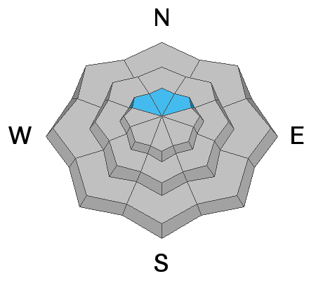
The avalanche danger is CONSIDERABLE in the high elevation northwest through southeast facing terrain. Human triggered avalanches are likely in this terrain. If you stay out of this described terrain, the avalanche danger is much lower.
Low
Moderate
Considerable
High
Extreme
Learn how to read the forecast here
Weather and Snow
We received another shot of snow over the last 24 hours. This time it looks like the Fairview Canyon region is the winner with a foot or more of new snow. Ephraim Canyon picked up about 7" and 12 Mile Canyon is about the same. The wind has been strong from the west northwest overnight. Temperatures have dropped to near 10˚F. It's still snowing fairly hard on the north Skyline and we might see a few more inches before it clears mid day.
To be honest, I have very little information about the current state of the snowpack. I have not been able to get into higher elevations since Wednesday. Here's what I do know.
  • There was 5 to 9 inches of old snow from October lingering in the upper elevation more northerly facing slopes. This snow had turned into weak sugar snow.
  • By Wednesday there was 2 to 3 feet of total snow in the upper elevations and it was unconsolidated with no base. You would sink right through to the ground.
  • On Thursday, east wind speeds were strong and drifted snow. 10 inches of snow was stripped off one of my storm boards which is used to measure storm snow.
  • On Friday, the Skyline received another foot of snow. Late Friday, the wind direction switched more to the west and speeds became strong.
  • As of this morning, storm totals for the week are about three feet containing nearly 3 inches of water. The wind is still blowing strong from the west northwest.
So, a lot has happened and I won't know exactly what is going on with the snowpack until I get up there today. The following are the two avalanche problems to be concerned for today.
Ad
Avalanche Problem #1
Wind Drifted Snow
Type
Location
Likelihood
Size
Description
The newest snow has been blown into deep drifts along the higher north through east through south facing terrain. The wind is still blowing this morning. These drifts are always the most sensitive when they are forming and directly afterward.
Avalanche Problem #2
Persistent Weak Layer
Type
Location
Likelihood
Size
Description
The small amount of old weak sugar snow on the ground is now covered up with around 2 to 3 feet of new snow. This old snow could collapse and cause the newer snow to avalanche. The question is, was there enough old snow present to create a dangerous weak layer? We won't know this until getting into the higher terrain and doing some investigations of the snowpack.
Additional Information
The reality is that because of the shallow snowpack and difficult travel conditions, it is unlikely that people will venture into terrain where there is avalanche danger. Most people won't be anywhere near where any avalanches might occur today. However, if you work at it, you certainly could climb into high elevation steep terrain and trigger an avalanche.

This forecast is from the U.S. Forest Service, which is solely responsible for its content. This forecast describes general avalanche conditions and local variations always occur.