Forecast for the Skyline Area Mountains

Brett Kobernik
Issued by Brett Kobernik on
Saturday morning, January 9, 2021
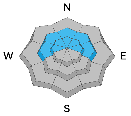
A CONSIDERABLE avalanche danger exists in the upper elevation west, north and east facing steep terrain. Although shallow snow makes it difficult to get into much of the steep terrain, if you do get into it you are almost sure to trigger an avalanche. Continue to avoid slopes over 30 degrees in steepness in the described terrain.
Low
Moderate
Considerable
High
Extreme
Learn how to read the forecast here
Weather and Snow
Current Conditions: There is still some nice snow around in spots that is decent for skiing and snowboarding. Snowmobiling is very limited in travel because of the shallow snowpack. We are seeing some light snowfall this morning but no accumulations as of 6am. Temperatures are in the upper teens and the wind is light to moderate in speed from the west northwest.
Mountain Weather: It's not a pretty picture. We might get a trace to an inch of snow this morning if we're lucky. Ahead of this weak little storm, there's nothing in sight for new snow. Today we'll see mostly cloudy skies with high temperatures in the upper teens and wind from the north which will bump up in speed a bit as the day goes on.
Recent Avalanches
There was one snowmobile triggered avalanche in the Ephraim Canyon zone on Friday. No one was caught. It was reported as around 175 feet wide with a fracture line up to 5 feet deep. It only ran a few feet in distance because it was located just above a flat bench. This is a good demonstration about how fragile the snowpack is. Scott Watson is going to go have a look today and submit a report later.
Ad
Avalanche Problem #1
Persistent Weak Layer
Type
Location
Likelihood
Size
Description
Here are your "red flags" for today. A persistent weak layer of faceted snow remains our biggest concern.
  • Collapsing of the snowpack continues to occur.
  • A recent human triggered avalanche occurred.
  • The snowpack structure is poor.
Additionally, the longer we go with no snow, the weaker the snowpack becomes. We are now seeing the snow from December turn to sugary facets. Locations that have less than a foot and a half of total snow are becoming completely faceted. This includes southerly facing slopes in many locations. If we ever get any serious amounts of snow, things will be quite dangerous.