Forecast for the Skyline Area Mountains

Brett Kobernik
Issued by Brett Kobernik on
Wednesday morning, January 15, 2020
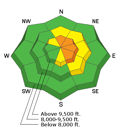
There has been a lot of wind drifting in the higher elevations over the last couple of days and these fresh drifts should be avoided today especially on the steep more east facing slopes. The avalanche danger is CONSIDERABLE in this terrain. Away from steep wind loaded slopes the avalanche danger is LOW to MODERATE.
Low
Moderate
Considerable
High
Extreme
Learn how to read the forecast here
Weather and Snow
Current Conditions: The west wind was strong on Tuesday but slowed down overnight. About 2 to 3 inches of new snow fell overnight. Temperatures are in the low to mid teens.
Weather Outlook: We have a couple of nice days ahead of us with mostly clear skies and high temperatures in the mid 20s. Another storm will move through Thursday night and Friday. It doesn't look huge but might bring 3 to 6 inches of new snow.
Ad
Avalanche Problem #1
Wind Drifted Snow
Type
Location
Likelihood
Size
Description
Wind drifted snow is your main concern today. These fresh drifts that formed the last few days are likely still sensitive today. Many of them are fairly large. They will adjust and become stable but you'll want to give them a day or two before messing around on them. The most dangerous places are along the higher elevation east facing ridges and steep slopes.
Additional Information
This forecast is from the U.S. Forest Service, which is solely responsible for its content. This forecast describes general avalanche conditions and local variations always occur.