Forecast for the Skyline Area Mountains

Brett Kobernik
Issued by Brett Kobernik on
Tuesday morning, January 14, 2020
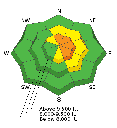
Out of wind affected terrain, the avalanche danger is LOW to MODERATE. In high steep terrain on the east side of the compass where recent wind drifts and wind slabs have formed, the danger is CONSIDERABLE. If you avoid wind affected steep terrain, you will stay safe today.
Low
Moderate
Considerable
High
Extreme
Learn how to read the forecast here
Weather and Snow
Current Conditions: The expected wave of snow on Monday fell apart and only produced a trace of snow. Ridgetop wind was a bit gusty on Monday. Fresh drifts that formed during the weekend storm were somewhat sensitive. This was mainly just along the east sides of ridges and terrain features.
Mountain Weather: We'll see a weak storm move through today which might give us a few inches of snow. Southerly wind is going to increase and it will feel blustery along the ridges. High temperatures will get into the low 20s today. Things clear out Wednesday and into Thursday and then the next storm moves in Thursday night into Friday perhaps bringing a few inches of snow.
Recent Avalanches
No significant avalanches have been reported from the last storm. I have noticed small wind drifts and cornices that released but they didn't cause any real avalanches.
Ad
Additional Information
This forecast is from the U.S. Forest Service, which is solely responsible for its content. This forecast describes general avalanche conditions and local variations always occur.