Forecast for the Skyline Area Mountains

Brett Kobernik
Issued by Brett Kobernik on
Monday morning, January 13, 2020
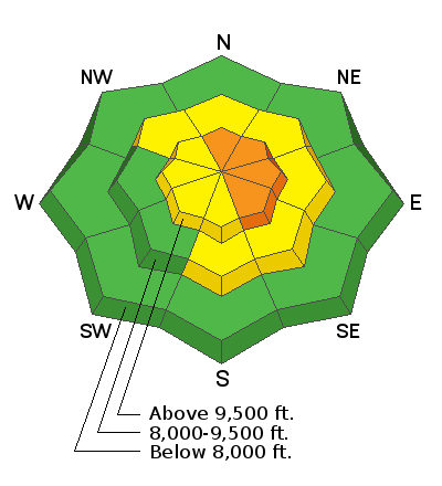
There is a CONSIDERABLE avalanche danger on the upper elevation steep slopes on the east side of the compass where fresh drifts of wind blown snow could likely be triggered by a person today. In terrain where the snow is not wind affected, the avalanche danger is a lot less.
Low
Moderate
Considerable
High
Extreme
Learn how to read the forecast here
Weather and Snow
Current Conditions: We picked up a few more inches of snow on Sunday bringing snow totals since Wednesday up to about 20 inches. Riding conditions are excellent with lots of deep powder. The west wind has been a little blustery along the highest terrain. It did not seem to be getting down into the canyons too much on Sunday. Temperatures are in the mid teens again this morning.
Weather: It looks like another wave will move through today bringing 3 to 5 inches of snow. West wind will continue in the moderate speed range and will feel a bit annoying in the higher exposed terrain. High temperatures will be in the upper teens. Another weak wave will bring a few more inches of snow on Tuesday night into Wednesday. Yet one more is shaping up for Thursday into Friday which should bring another shot of snow.
Ad
Additional Information
This forecast is from the U.S. Forest Service, which is solely responsible for its content. This forecast describes general avalanche conditions and local variations always occur.