Join us at our 2nd Annual Blizzard Ball

Forecast for the Provo Area Mountains

Greg Gagne
Issued by Greg Gagne on
Friday morning, February 26, 2021
Areas of CONSIDERABLE danger exist at the upper elevations, and at mid-elevations on aspects facing northwest through northeast where human-triggered avalanches are likely. On these slopes, avalanches may break down 4-6' deep, hundreds of feet wide, and run over a thousand feet. Strong winds will create sensitive fresh wind drifts on all aspects at the mid and upper elevations.
A MODERATE danger exists at the low elevations and mid-elevation aspects facing west through south.

Watch for changing avalanche conditions today, with a rising avalanche danger possible due to strong winds.
Low
Moderate
Considerable
High
Extreme
Learn how to read the forecast here
Special Announcements
For those traveling to the Salt Lake mountains, Grizzly Gulch will be closed to all travel, Friday 2/26 from 8am–4pm while equipment works to put in the Grizzly road.
Weather and Snow
This Morning: Temperatures range through the low to mid teens F. and skies are mostly cloudy. Strong winds from the west/northwest began to increase later yesterday afternoon and overnight. At the mid-elevations, winds are averaging in the teens and 20's mph, with gusts in the 30's. Along the uppermost ridges, winds are much stronger, averaging in the 30's with gusts near 70 mph.
For Today: We may pick up an inch or two of snow this morning, followed by a break in the snowfall until late this afternoon. Although the snowfall is likely to diminish today, strong west/northwest winds will persist. At the mid-elevations winds will average in the 20's with gusts in the 40's mph. At the upper elevations, winds will average in the 30's with gusts over 60 mph. Temperatures will rise into the low 20's F.
Overnight and into Saturday: Snowfall should begin to pick up late in the day, and continue overnight and into Saturday, with totals of 8-12".
Recent Avalanches
No new avalanches were reported from the backcountry yesterday. You can read all the recent observations HERE.

For those that travel to the Salt Lake mountains, catch up on significant weather and avalanche events by reading our Week in Review.
Ad
Avalanche Problem #1
Persistent Weak Layer
Type
Location
Likelihood
Size
Description
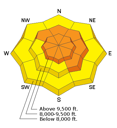
Although the snowpack was slowly adjusting the past week to the several feet of snow from Feb 12-19, strong winds overnight and into today will add a new load, further stressing the buried persistent weak layer (PWL) on slopes with fresh wind drifts. Look at the locator rose for this PWL problem to see how it is distributed (all upper-elevation aspects and mid-elevations west through north through southeast) where triggering avalanches several feet deep and hundreds of feet wide is possible. I am most concerned about areas where the snowpack is shallow, such as steep, rocky terrain or slopes that have previously avalanched. I also am finding a weaker and thinner snowpack structure outside of the upper Cottonwoods, such as Millcreek Canyon and the Park City Ridgeline.
We may see this weak layer become active: Strong winds and forecasted snowfall tonight and into Saturday will further stress the PWL.

Most folks I know continue to be wary of our PWL problem and are avoiding steep slopes where this problem exists. Yesterday, I was on top of an untracked, 32° slope (avalanche terrain) on a NE aspect. I used my probe and found the snowpack to be ~150 cms deep, with a 4F/1F hard, 1-meter slab on top of 30-40 cms of weak facets. Although I wasn't getting any collapsing or other signs of instability, I did not like the structure of a strong slab on top of weak facets and backed off. Instead, I moved to an adjacent 28° slope which was not in avalanche terrain.
Avalanche Problem #2
Wind Drifted Snow
Type
Location
Likelihood
Size
Description
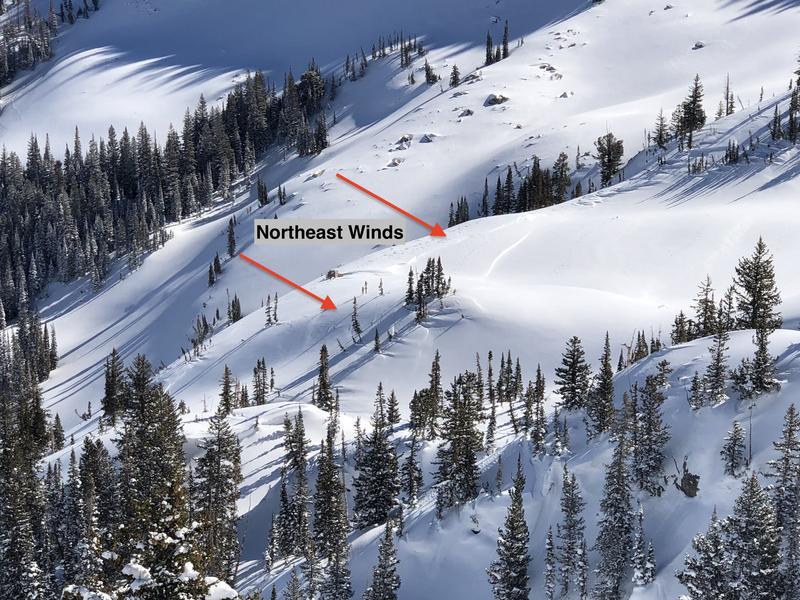
Moderate to strong winds from the west to northwest will move Wednesday's 2-5" of low-density snow and create fresh drifts at the mid and upper elevations. Although these drifts should generally be shallow (less than a foot) you can expect to find them on all aspects due to cross-loading around terrain features. Today's strong winds will also drift snow well-down from ridges, especially in exposed terrain.
Watch for signs of fresh drifting such as rounded pillows of snow. The photo below is from Thursday where cross-loading occurred about 500' below ridgetops.
Today's winds will also further develop our increasingly-large cornices. Be sure to stay out from underneath and well back from corniced ridgelines.
General Announcements
Please visit this website with information about Responsible Winter Recreation by the Utah Office of Outdoor Recreation.

This information does not apply to developed ski areas or highways where avalanche control is normally done. This forecast is from the U.S.D.A. Forest Service, which is solely responsible for its content. This forecast describes general avalanche conditions and local variations always occur.