Join us at our 2nd Annual Blizzard Ball

Forecast for the Provo Area Mountains

Trent Meisenheimer
Issued by Trent Meisenheimer on
Thursday morning, February 25, 2021
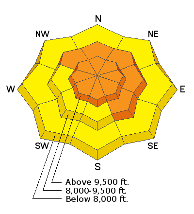
Areas of CONSIDERABLE avalanche danger exist on many slopes at the mid and upper elevations. The avalanche danger is most prevalent on the west to north to southeast-facing slopes where weak faceted snow exists and on any recent wind drifted slope.
Considerable means; that dangerous avalanche conditions exist, careful snowpack evaluation, cautious route-finding, and conservative decision-making skills are essential.

Cornices are large and should be avoided. Give these yawning giants a wide berth if traveling on or below ridgelines.
Low
Moderate
Considerable
High
Extreme
Learn how to read the forecast here
Weather and Snow
Yesterday, a trace to five inches of new snow fell across the Wasatch mountains. It should be a beautiful sunrise over the Wasatch mountains this morning with clear skies and cold temperatures. Today's high pressure will be brief as a weak wave pushes in later this afternoon, bringing another round of light snowfall into Friday. Right behind this weak wave is a much better-looking trough on a northwest flow that should bring some higher quality snowfall to Northern Utah. By Sunday, we could see 4-8 inches of new snow with about an inch of snow water equivalent.
It's cold out there; mountain temperatures are in the single digits to low teens °F with wind chills in the negative digits. Winds are from the northeast and are spinning anemometers 10-20 mph with gusts into the 20's across all upper elevation ridgelines. Mountain temperatures should warm into the mid 20's °F later this afternoon. The northeast winds should be short-lived and eventually back (rotate counter-clockwise) to the west and decrease in speed ahead of our next storm system this afternoon.
Recent Avalanches
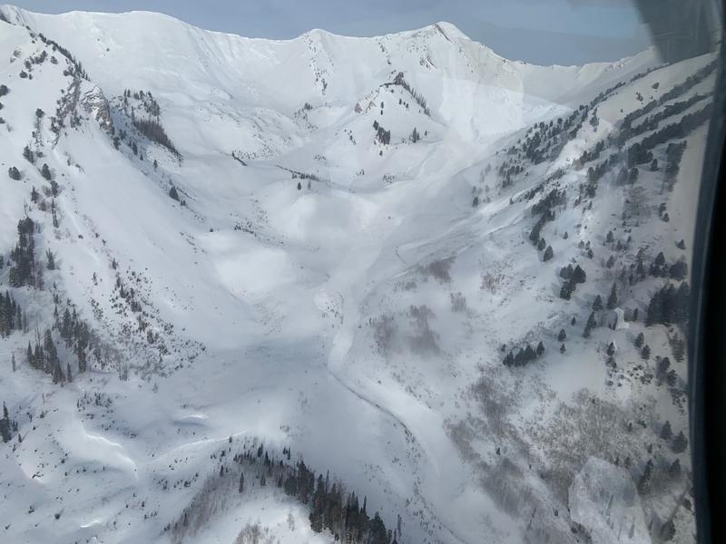
No new avalanches were reported from the backcountry yesterday. You can read all the recent observations HERE. However, on Monday the Powderbirds did some explosive testing in the Provo zone and triggered a very large slide off Provo Peak on a SE facing slope that ran 3,000 vertical feet (pic below).
Ad
Avalanche Problem #1
Persistent Weak Layer
Type
Location
Likelihood
Size
Description
The snowpack is adjusting to last week's heavy new snow and becoming more and more stable every day. However, the poor snowpack structure of really strong snow over weak snow remains in many places across the mountains. The most suspect slopes will continue to be on the north half of the compass including southeast and/or in areas where the snowpack is shallow. Steep rocky terrain or terrain that has previously avalanched will also be more suspect to avalanching.
The likelihood of triggering a deep and dangerous avalanche is going down, BUT if you do trigger an avalanche on any faceted weak layer, it's likely going to be unsurvivable. These avalanches are tree snapping, bone-crushing avalanches that shouldn't be messed with. We have entered the era of low probability, high consequence.
Personally, I am not ready nor willing to trust steep northerly terrain. I am fine with waiting. This is one of those years where the snowpack is dangerous, and avoidance is key. It will be hard not to be lured into steeper terrain because the snow and powder will be very enticing. I am not writing this and heading out the door to ride steep lines. All of us at the UAC are being very patient and avoiding avalanche terrain. Every professional I've talked with over the past week is also being very conservative and giving this snowpack time to heal.
If you are heading into the backcountry, here are a few tips and reminders:
  • Before committing to any steep slope -dig down (in a safe location), and if you see weak facets in the snowpack, then avoid that terrain.
  • Choose a completely safe uptrack. You are often more vulnerable while ascending.
  • Expose only one person at a time and keep tabs on people all the time. Keep people in places ready to aid in a rescue if needed, but remember, 1 out of 4 people die before the avalanche stops.
  • Know what's above and connected to you - these avalanches can be triggered from a distance or below.
  • Slope cuts and cornice drops can be dangerous and dangerously misleading indicators of stability.
If all of this sounds confusing and hard to understand (it's okay) - take a step back and only ride in terrain that's under 30 degrees in steepness and continue to avoid avalanche terrain altogether. (my plan)
Avalanche Problem #2
Wind Drifted Snow
Type
Location
Likelihood
Size
Description
The past few days, the winds have been from the northwest and blowing with elevated wind speeds that drifted snow on many aspects at the mid and upper elevations. Overnight the winds veered to the northeast and are blowing 10-20 mph across the upper elevation terrain. I don't expect these northeast winds to change much out in the mountains, but wind drifted snow should always be on your radar.
Remember, winds can deposit the lingering snow around terrain features on almost any aspect, called cross-loading. For this reason, I would expect to find hard or soft slabs of wind drifted snow at all upper elevations and on leeward mid-elevation slopes, especially along with terrain features such as ridgelines, sub ridges, and gullies. As always, look for and avoid slopes that look rounded, pillowy, or sound hollow.
Cornices have grown to an unmanageable size. Stay well back from - and avoid travel below - corniced ridges.
General Announcements
Please visit this website with information about Responsible Winter Recreation by the Utah Office of Outdoor Recreation.

This information does not apply to developed ski areas or highways where avalanche control is normally done. This forecast is from the U.S.D.A. Forest Service, which is solely responsible for its content. This forecast describes general avalanche conditions and local variations always occur.