Join us at our 2nd Annual Blizzard Ball

Forecast for the Provo Area Mountains

Nikki Champion
Issued by Nikki Champion on
Tuesday morning, January 5, 2021
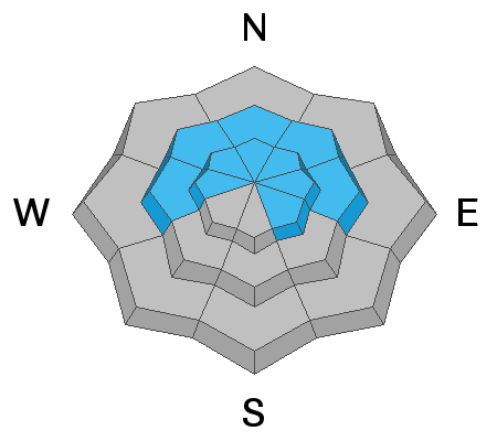
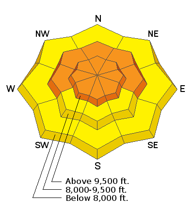
Today, we have a CONSIDERABLE avalanche danger on all steep upper elevation slopes where fresh wind drifts and new snow sit atop of the weak faceted snow. There is also a CONSIDERABLE danger on mid-elevation slopes facing west through north through east. Stay off of and out from underneath slopes 30° degrees and steeper at the mid and upper elevations. If you trigger an avalanche, it is likely to break down 1-3' and up to several hundred feet wide.
The remaining aspects and elevations have a MODERATE danger.

There are three avalanche problems to watch for: (1) triggering a slab avalanche 2-4' deep in the weak faceted snow, (2) soft slabs of wind drifted snow that would likely steep down into the weak snow below, and (3) sluffing within the new snow.
Low
Moderate
Considerable
High
Extreme
Learn how to read the forecast here
Special Announcements
The UAC offers great blog posts and a podcast! Stream here or tune in wherever you get your favorite podcasts and check out the newest blog posts to be published.

UAC forecasters Paige Pagnucco and Greg Gagne discussing danger ratings and persistent weak layers.

Thanks to the generous support of our local resorts, Ski Utah, and Backcountry, discount lift tickets are now available. Support the UAC while you ski at the resorts this season. Tickets are available here.
Weather and Snow
This morning, under overcast skies snow, it is finally snowing. Mountain temperatures are in the upper 20s °F. Winds have been elevated since yesterday, gusting up to 80 mph at times at nearby Hidden Peak. Currently, winds westerly and averaging 15-20 mph at mid-elevations, with gusts near 30 mph. Snow started falling last night, and really picked up this morning. As of 0500 we have gotten 3" (.30 water)
Today, periods of snow will persistent this morning before high pressure builds across the region this afternoon. Temperatures will be in the upper 20s to low 30s °F, and winds will become northwesterly and remain elevated all day. Mid-elevation winds will average 15-25 mph with gusts up to 35 mph. Upper elevation winds will average 25-35 mph, with gusts up to 55 mph. By the time it stops snowing snow totals should be 3-7"(0.30-0.65 water).
Heads up: High winds and high snowfall rates are both big red flags that avalanche danger is on the rise. The snow conditions will have changed greatly overnight.
Recent Avalanches
No new avalanches reported in the Provo backcountry.
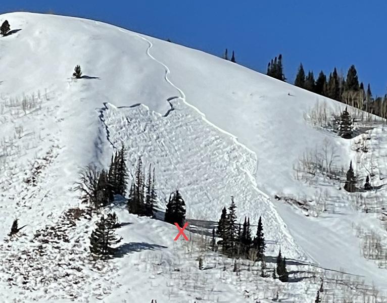
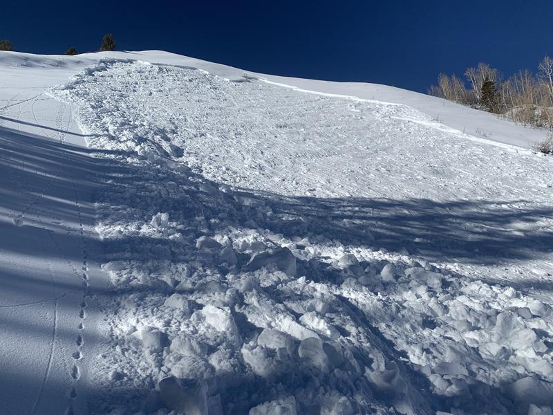
Yesterday, there was one new human triggered avalanche in the Central Wasatch. Off the Park City Ridge, on an East Aspect at 9200' on a zone known as Sound of Music. The soft slab failed down on the persistent weak layer of facets, 125' wide and ran 200' down. This avalanche was unintentionally triggered from lower on the slope.
Photos of Sound of Music avalanche, x marks the area in which the rider stepped out of his binding and noticed the avalanche coming from above.
Check out all recent observations HERE.
Ad
Avalanche Problem #1
Persistent Weak Layer
Type
Location
Likelihood
Size
Description
Throughout Utah, dangerous slabs of snow hang in the balance on many aspects and elevations from west to north to easterly facing terrain at the mid and upper elevations. With every bump in wind speed and or new snow (water) added to our fragile snowpack, we continue to wait for the snowpack to become unglued. This morning we added two huge new stressors to this fragile snowpack in the form of elevated winds, and new snowfall. We don't know if this is the tipping point that will cause the snowpack to become unglued, but we do know that the avalanche danger and likelihood of avalanche danger will be on the rise.
The most likely places to trigger a slide in that persistent weak layer are slopes with some wind-loading especially on more northerly facing slopes with the weakest snow. The little extra weight of wind drifted snow today keeps the buried facets stressed and ready to fracture.
If you're new to dealing with Persistent Weak Layer issues, head to a low angle slope with nothing steep overhead or adjacent to you and pull out the shovel and dig to the ground. You will see strong snow over very fragile and weak faceted snow.
Today, human-triggered avalanches are likely, these avalanches can be large enough to catch, carry, bury, and kill a person. Given the new snowfall, elevated winds, and poor snowpack structure I would avoid any terrain steeper than 30 degrees, with any steep terrain above or attached to it. Today is not the day to push it.
Avalanche Problem #2
Wind Drifted Snow
Type
Location
Likelihood
Size
Description
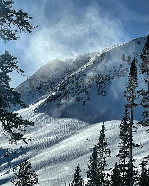
The winds have been cranking now for two days, early this morning Hidden Peak saw wind speeds over 80 mph. These strong winds have been These strong winds in combination with a few inches of new snow over will have drifted snow and formed fresh slabs. The winds didn't have a ton of new snow to move around yesterday, but with such high winds, any snow that was available for transport will have been transported. The issue with yesterday's freshly formed wind slabs is they will likely be hidden under a few inches of new snow from this morning and harder to identify this morning.
Know that shallow slabs of wind drifted snow will exist on mid and upper elevation terrain features that snow could be deposited, such as ridgelines and gullies.
Elevated winds this afternoon will continue to form both soft and hard slab avalanches in mid and upper elevation wind drifted terrain. As the winds continue to blow, these slabs will become more firm and cohesive. This can allow you to travel out farther onto the slope before it breaks, and can fail larger and wider than expected. High winds can deposit snow on all aspects but give west through north through east extra caution, as triggering an avalanche that initially fails in the wind-drifted snow will likely break down more deeply into the weak faceted snow below.
Photo from Cardiff Fork of obvious wind loading occurring. PC: M. White

Look for any slopes with signs of wind drifted snow, and avoid those slopes.
Avalanche Problem #3
New Snow
Type
Location
Likelihood
Size
Description
Today we should be getting 3-7" of new snow by the time all is said and done. While snow totals are important, what we truly pay attention to is at what RATE that snowfalls and how quickly it loads the snowpack. We call this precipitation intensity, and if those rates stay elevated or increase throughout the morning we could see the avalanche danger spike and more new snow avalanches occurring. Keep an eye on the sky, if the snow rate rapidly increases you know the danger is on the rise.
The new snow should produce loose snow sluffs or point releases, primarily in upper and mid-elevation terrain features protected from the wind. These typically break at your feet and not a major concern.

Terrain traps like gullies or creeks can cause these sluffs to pile up debris much deeper and could be enough to bury a person. Pay attention to the terrain you are traveling above.
General Announcements
Please visit this website with information about Responsible Winter Recreation by the Utah Office of Outdoor Recreation.

This information does not apply to developed ski areas or highways where avalanche control is normally done. This forecast is from the U.S.D.A. Forest Service, which is solely responsible for its content. This forecast describes general avalanche conditions and local variations always occur.