Join us at our 2nd Annual Blizzard Ball

Forecast for the Provo Area Mountains

Nikki Champion
Issued by Nikki Champion on
Monday morning, January 4, 2021
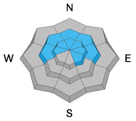
The most likely place to trigger an avalanche today will be all steep upper elevation slopes, especially where fresh slabs of wind drifted snow sit atop weak faceted snow. The avalanche danger is MODERATE in these locations.
You will also find a MODERATE avalanche danger on steep slopes facing west to north to southeast at the mid-elevations.
All other aspects have a LOW avalanche danger.
Pay attention to changing conditions ahead of Tuesday's storm, heavy snowfall and increased winds will cause the avalanche danger to rise throughout the night.
Low
Moderate
Considerable
High
Extreme
Learn how to read the forecast here
Special Announcements
The UAC offers great blog posts and a podcast! Stream here or tune in wherever you get your favorite podcasts and check out the newest blog posts to be published.

UAC forecasters Paige Pagnucco and Greg Gagne discussing danger ratings and persistent weak layers.

Thanks to the generous support of our local resorts, Ski Utah, and Backcountry, discount lift tickets are now available. Support the UAC while you ski at the resorts this season. Tickets are available here.
Weather and Snow
This morning, under mostly clear skies, the current mountain temperatures are in the low to mid-20s °F. Yesterday we had a few hours of high winds and gusts up to 60 mph at Hidden Peak, and 30 mph in Provo but this morning the winds have finally died off and are calm with upper elevation gusts below 20 mph. Yesterday's storm brought 0-1" of new snow (0-.02" water) to the mountains.
Today, the southwest flow will strengthen ahead of Tuesday's quick-hitting storm. This will bring a mixture of sun and clouds in the morning before increasing cloud cover this afternoon. Temperatures will be in the upper-30s F, and winds will southwesterly and increasing throughout the day. Mid-elevation winds will be 20-30 mph with gusts up to 45 mph and upper elevation winds will be the same with gusts up to 50 mph.

The good news, Tuesday's trough is still on track to perform, and we should see 3-6" of new snow by Wednesday morning. After that, the flow begins to split once again, and we are back to the dribs and drabs of snow for the rest of the extended forecast. For the optimistic fans - there is a larger trough in the forecast models on the 16th.
Recent Avalanches
No new human triggered avalanches reported in the Provo backcountry yesterday.
Check out all recent observations HERE.
Ad
Avalanche Problem #1
Persistent Weak Layer
Type
Location
Likelihood
Size
Description
Throughout Utah, dangerous slabs of snow hang in the balance on many aspects and elevations from west to north to easterly facing terrain at the mid and upper elevations. With every bump in wind speed and or new snow (water weight) added to our fragile snowpack, we continue to wait for the snowpack to become unglued. We don't know exactly when the tipping point will come, but each bump in wind speed and added water weight, just like we had yesterday will only increase the likelihood of avalanches and increase the avalanche danger.
This poor snowpack structure is enough for me to avoid all steep upper elevation shady terrain altogether. It's just not the year for steep riding in the Wasatch. If you're new to dealing with Persistent Weak Layer issues, head to a low angle slope with nothing steep overhead or adjacent to you and pull out the shovel and dig to the ground. You will see strong snow over very fragile and weak faceted snow.
Human-triggered avalanches are likely today, and these avalanches can be large enough to catch, carry, bury, and kill a person. Avoidance is the key to longevity in the mountains.
Avalanche Problem #2
Wind Drifted Snow
Type
Location
Likelihood
Size
Description
After two days of relatively high winds at upper elevations, the winds have finally decreased this morning before they increase again this afternoon. These strong winds in combination with a few inches of new snow will have drifted snow and formed fresh slabs today. These wind drifts will be small, as they only had a few inches of snow to move around, but with such strong winds, any snow that could be transported will have been transported.
Look for shallow slabs of wind drifted snow on isolated upper elevation terrain features that snow could be deposited, such as ridgelines and gullies.
Elevated winds this afternoon will continue to form both soft and hard slab avalanches in upper elevation wind drifted terrain. As the winds continue to blow, these slabs will become more firm and cohesive. This can allow you to travel out farther onto the slope before it breaks, and can fail larger and wider than expected. High winds can deposit snow on all aspects but give west through north through east extra caution, as triggering an avalanche that initially fails in the wind-drifted snow will likely break down more deeply into the weak faceted snow below.
Look for any slopes with signs of wind drifted snow, and avoid those slopes.
General Announcements
Please visit this website with information about Responsible Winter Recreation by the Utah Office of Outdoor Recreation.

This information does not apply to developed ski areas or highways where avalanche control is normally done. This forecast is from the U.S.D.A. Forest Service, which is solely responsible for its content. This forecast describes general avalanche conditions and local variations always occur.