Join us at our 2nd Annual Blizzard Ball

Forecast for the Provo Area Mountains

Drew Hardesty
Issued by Drew Hardesty on
Wednesday morning, January 6, 2021
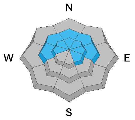
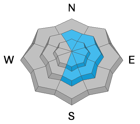
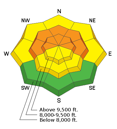
A CONSIDERABLE AVALANCHE DANGER exists on many steep slopes in the backcountry. Human triggered avalanches 1-2' deep and 200' wide are likely and most prevalent on steep west to north to east facing slopes at the mid and upper elevations. Avalanches may be triggered on, adjacent to, or below steep slopes. A MODERATE danger exists for triggering a lingering wind drift at the mid and upper elevations. Wet rollerballs and sluffs are possible on steep sunny aspects by midday.
The Good News: excellent riding conditions exist on low angle slopes.
Low
Moderate
Considerable
High
Extreme
Learn how to read the forecast here
Special Announcements
The UAC offers great blog posts and a podcast! Stream here or tune in wherever you get your favorite podcasts and check out the newest blog posts to be published.

Thanks to the generous support of our local resorts, Ski Utah, and Backcountry, discount lift tickets are now available. Support the UAC while you ski at the resorts this season. Tickets are available here.

***Canyons will be conducting avalanche control work in the Condor/Murdock area this morning. Please avoid this terrain.***
Weather and Snow
Skies are clear. It'll be glorious in the mountains today, but conditions are ripe for an avalanche accident.
Storm totals through yesterday morning are 3-6" in the Provo mountains.
West to northwest winds blew moderate to strong through Tuesday morning before losing steam. They're now generally less than 15mph from the west northwest.
Temperatures have inverted with a ridge of high pressure building overhead. Ridgetop temps are in the upper teens to low 20s; basins are in the single digits.
Alas, mountain temperatures will exceed 0°C/32°F in the upper elevation bands today and snow surface conditions on the sunny aspects will take a hit. Some wet sluffs may be expected by midday.
The Outlook: A weak system noses in Thursday that will cool things a touch and bring some cloud cover. Friday night's storm may offer 2-4", perhaps more.
Recent Avalanches
Yesterday, UDOT Provo Canyon avalanche forecasters spotted some natural avalanches high along the Cascade Ridgeline south of Provo Canyon. These were on steep northeast aspects and avalanched due to the stronger winds. A ski cut released a small slab at 7400' that ran 200' downslope.
Ad
Avalanche Problem #1
Persistent Weak Layer
Type
Location
Likelihood
Size
Description
Many steep slopes are hanging in the balance, waiting for a trigger. Recent avalanches as well as collapsing and cracking are bullseye clues that conditions are hazardous to your health if entering steep terrain today.
There's little mystery here: recent storm snow and moderate to strong winds have built a slab that teeters unsteadily over very weak sugar snow and we have a classic upside down strong over weak, unstable snow structure.
This unstable snow structure exists on many west to north to southeast facing slopes at the mid and upper elevations.
As I see it, you have three options;
Avoid the terrain (aspects and elevations) that harbors this unstable snow structure.
Choose this terrain but stick to the low angle slopes with no overhead hazard.
Roll the dice and hope for the best. But as I said earlier, conditions are ripe for an avalanche accident today.
Avalanche Problem #2
Wind Drifted Snow
Type
Location
Likelihood
Size
Description
Skier and riders triggered a few wind slab avalanches yesterday in upper elevation east facing terrain in the central Wasatch yesterday. You can still trigger these wind drifts today. KNOW that if you trigger a wind drift in west to north to east facing terrain that this initial avalanche may step down into deeper layers in the snowpack, resulting in a much more dangerous avalanche.
General Announcements
Please visit this website with information about Responsible Winter Recreation by the Utah Office of Outdoor Recreation.

This information does not apply to developed ski areas or highways where avalanche control is normally done. This forecast is from the U.S.D.A. Forest Service, which is solely responsible for its content. This forecast describes general avalanche conditions and local variations always occur.