Join us at our 2nd Annual Blizzard Ball

Forecast for the Provo Area Mountains

Greg Gagne
Issued by Greg Gagne on
Friday morning, January 15, 2021
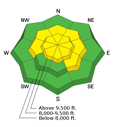
The avalanche danger is MODERATE at the upper elevations as well as mid-elevations facing west, north, through southeast where it is possible to trigger a large avalanche failing in a buried persistent weak layer. Any avalanches could be 1-3' deep and over 100' wide. You may also find reactive slabs of wind-drifted snow at the upper elevations as well as some mid-elevation slopes. Mid-elevations facing south and southwest, as well as lower elevations, have a Low danger.
This is not a time to let your guard down - continue to practice cautious route-finding and conservative decision-making.
REMEMBER - IF YOU ARE GOING OUT OF BOUNDS AT A SKI AREA, YOU ARE ENTERING THE BACKCOUNTRY WITH AN INHERENT AVALANCHE DANGER.
Low
Moderate
Considerable
High
Extreme
Learn how to read the forecast here
Special Announcements
Thanks to the generous support of our local resorts, Ski Utah, and Backcountry, discount lift tickets are now available. Support the UAC while you ski at the resorts this season. Tickets are available here.
Weather and Snow
This Morning: Skies are clear and temperatures range through the teens. Winds are from the north/northwest and their strength is very elevation-dependent:
  • below about 10,000' winds are less than 10 mph with some gusts in the teens;
  • once you approach about 10,000' winds pick up, averaging in the teens with gusts in the 20's mph;
  • at 11,000 winds are strong, averaging in the 30's mph with gusts around 50 mph.
Today: Clear skies and temperatures warming into the 30's F. Wind will from the west/northwest and remain moderate to strong, with gusts in the 20's at the mid-elevations, while the upper-elevations will average in the 30's mph and gusts in the 50's mph.
Overnight: Skies will cloud up as a weak storm system enters the region. A trace of snow is possible by Saturday morning.
Weekend and Beyond: Dry conditions over the weekend, with another weak system by late Sunday. A glimmer of hope for some storms to finally reach our region by late-week.

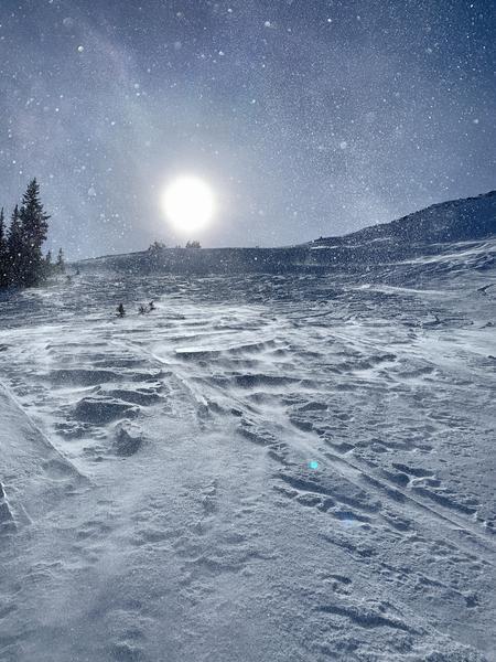
This photo [Will McKay] below shows the effects of recent winds in exposed alpine terrain:
Recent Avalanches
No avalanches were reported from the backcountry on Thursday.
Although specific to the Salt Lake mountains, our Week in Review - where we highlight significant avalanche and weather events - has been published.
Ad
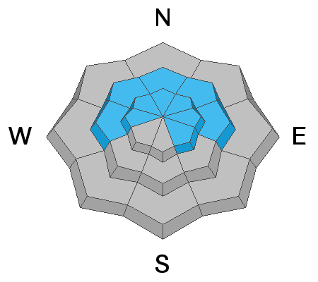
Avalanche Problem #1
Persistent Weak Layer
Type
Location
Likelihood
Size
Description
We have a poor snowpack structure with strong snow over weak snow. And although we have received no snow this past week, there has been moderate to strong winds the past few days that have created areas with a denser slab of wind-blown snow on top of this weaker faceted snow. Over this past week there have been fewer avalanches and less collapsing and cracking reported, but some recent field observations in the Salt Lake mountains still report full propagation with extended column tests, indicating the propensity of the slab to propagate if you did get a collapse of the buried persistent weak layer.
This poor structure is present on mid and upper elevation slopes facing west, through north, to southeast. Although avalanches are becoming less common, they are still possible and I would not be surprised to hear of another human-triggered avalanche failing on this buried persistent weak layer and I personally will continue to avoid slopes steeper than 30° in this suspect terrain.
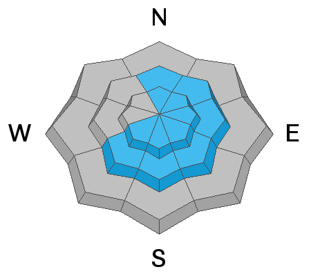
Avalanche Problem #2
Wind Drifted Snow
Type
Location
Likelihood
Size
Description
Strong winds the past few days have created hard wind drifts in isolated areas at the mid and upper elevations. Although the winds have been primarily from the west/northwest when winds are this strong they can work through terrain and create drifts on almost any aspect.
General Announcements
Please visit this website with information about Responsible Winter Recreation by the Utah Office of Outdoor Recreation.

This information does not apply to developed ski areas or highways where avalanche control is normally done. This forecast is from the U.S.D.A. Forest Service, which is solely responsible for its content. This forecast describes general avalanche conditions and local variations always occur.