Forecast for the Moab Area Mountains

Eric Trenbeath
Issued by Eric Trenbeath on
Thursday morning, March 5, 2020
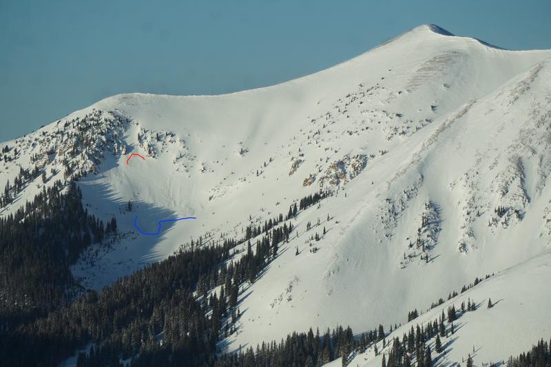
The avalanche danger remains MODERATE today with unstable areas of wind drifted snow being your primary concern. Look for recently formed wind drifts on the lee sides of ridge crests and terrain features in upper elevation, wind exposed terrain. Fresh drifts are recognizable by their smooth, pillowy, or rippled appearance. It may also still be possible to trigger loose snow avalanches on very steep, northerly facing slopes. And finally, avalanches triggered in the most recent snow have the potential to step down into older weaker snow on steep, shady aspects. Continue to approach steep terrain with caution and be aware of consequences such as being swept over rocks, cliffs, or into trees.
Low
Moderate
Considerable
High
Extreme
Learn how to read the forecast here
Special Announcements
Road Conditions: Grand County plowed on Monday.
Grooming Report: Grooming is scheduled for Friday.
Weather and Snow
24 Hour Snow 0" Weekly Snow 13" Base Depth in Gold Basin 56" Wind NW 5-10 mph Temp 18F
Weather: Skies are clear, winds are light from the NW, and temps are in the high teens to low 20's. Today look for sunny skies, light southerly winds, and high temps up around 40 degrees. A change in the pattern starts to occur on Saturday with a little snow likely on Sunday.
Snowpack: Sun exposed slopes have developed a stout, breakable crust, and the wind has affected exposed northerly aspects. Nevertheless, Reed Kennard was up yesterday and reported that it's still possible to find good snow in sheltered locations. Read his observation here.
Warm temps over the past few days have helped to stabilize new and wind drifted snow though avalanches failing on a variety of weak and slick bed surfaces remain possible. Underneath, the snowpack has deteriorated into non-cohesive layers of loose, weak, sugary, facets. In some areas, crusts of varying strengths and thicknesses are overlying this weak snow, while in others, the underlying snowpack is completely unsupportable. With the added new snow on top, we've had concerns that triggering an avalanche deeper in the snowpack could be possible. My suspicions were confirmed when I received this report of an intentionally triggered avalanche on Tuesday that started in the most recent snow, and then stepped down into older, weaker facets that eventually slid out to the ground.
Wind, temperature, humidity on Pre Laurel Peak (11,700')
Storm totals at Gold Basin Study Plot (10,000').
Snotel site near Geyser Pass Trailhead (9600').
Recent Avalanches
I received this report of an intentionally triggered avalanche on Tuesday that started in the most recent snow, and then stepped down into older, weaker facets that eventually slid out to the ground.
Wide spread avalanching within the new snow occurred during the storm with most of the steep, upper elevation N-E faces producing loose snow slides. A few fractures indicating soft slab avalanches were also observed.
Aerial observer Chris Benson flew around on Tuesday and observed lots of loose avalanche activity from the storm on the north end of the range. Read his report with pictures here. He also observed this slab avalanche in Beaver Basin.
Ad
Avalanche Problem #1
Wind Drifted Snow
Type
Location
Likelihood
Size
Description
Moderate to strong northwest winds on Monday and Tuesday have blown and drifted snow in the upper elevations. Time and warm temps have helped to stabilize things, but unstable drifts may still exist. Continue to avoid steep slopes with smooth, pillowy looking deposits of wind drifted snow. Most of the snow has been deposited on slopes facing NE-SE-S, but cross-loading is also a factor on slopes with a westerly component. In some areas, a triggered wind slab may have the potential to step down into buried, weak, faceted snow causing a deeper and more dangerous avalanche.
Aerial observer Chris Benson shot this clip of active wind-loading on Monday.
Avalanche Problem #2
Persistent Weak Layer
Type
Location
Likelihood
Size
Description
Human triggered avalanches involving recent or wind drifted snow have the potential to step down into buried persistent weak layers of loose, sugary, faceted snow. You are most likely to encounter this problem on steep, northerly facing slopes where the underlying snowpack is unsupportable, or where buried layers of near-surface facets exist. Exercise caution on steep, north-facing slopes, especially where wind-loaded, and keep an eye toward consequences such as being scraped over rocks or into trees.
General Announcements
Check out the avalanche beacon training park at the Geyser Pass Trailhead and practice your rescue skills!
This forecast is from the U.S. Forest Service, which is solely responsible for its content. This forecast describes general avalanche conditions and local variations always occur.