Forecast for the Moab Area Mountains

Dave Garcia
Issued by Dave Garcia on
Thursday morning, March 27, 2025
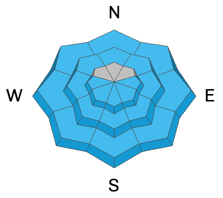
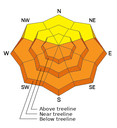
This morning, the danger is MODERATE on steep sunny slopes that face W-S-E and northerly aspects near treeline and below for avalanches involving wet snow. As the day heats up, the danger will rise to CONSIDERABLE on steep slopes facing W-S-E, and natural and human-triggered avalanches are LIKELY. Most activity will involve wet-loose avalanches, but the potential for wet slab avalanches is increasing each day. Pay attention to the snow surface, and start and end your day early to increase your margin of safety.
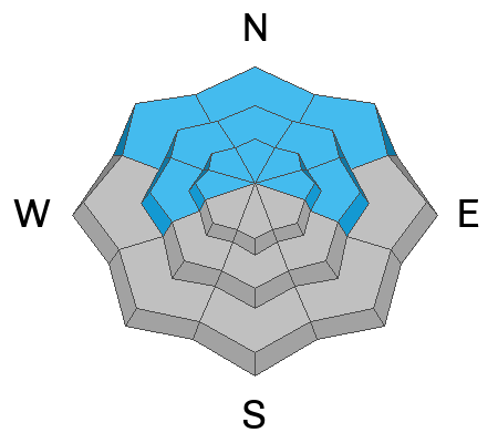
The danger is MODERATE on steep slopes facing W-N-E near and above treeline, and on northerly aspects below. In these areas deep and dangerous, human-triggered avalanches failing on a buried persistent weak layer are possible. The danger is greatest on steep slopes near treeline that face N-NE. While the likelihood of triggering this type of avalanche is decreasing, the consequences remain severe.
Low
Moderate
Considerable
High
Extreme
Learn how to read the forecast here
Special Announcements
Our Spring Campaign is in full swing, and there are two great ways to support forecasting, awareness, and education across Utah: Donate to our Spring Campaign, or Bid on items in our Spring Auction. Every dollar donated helps keep the backcountry community on top.
Construction will resume on the Loop Road today. It will be closed near Pack Creek from 8:30-5:30.
Geyser Pass Road: The road is plowed and is melting out down to the dirt.
Grooming Conditions: Trails were last groomed on Thursday.
Weather and Snow
6 A.M. Snow and Weather Data
24 Hour Snow: 0" 72 Hour Snow: 0" Season Total Snow: 121" Depth at Gold Basin: 44"
Winds on Pre-Laurel Peak: SW 5-10 MPH Temp: 33° F
Weather
Under clear skies it is 33° F in Gold Basin this morning. Today will be sunny and temperatures will once again sky rocket to 56° F at 10,000'. Winds will blow out of the southwest at 10-15 MPH this morning and increase to 20-25 MPH this afternoon with gusts up to 35 MPH. Strong winds will continue overnight into Friday as a Pacific storm heads our way on a southwest flow. On Friday temperatures will drop about 10° F and we will see increasing clouds and a 30% chance of snow in the afternoon. High temperatures fall back to normal on Saturday and the pattern looks unsettled into early next week.
General Conditions
Conditions will be sloppy out there today and it may be a good day to play in the desert. The mountains did not get a refreeze last night. The window for traveling on solars will be very short, and steep sunny slopes will need to be avoided for much of the day. Today will be the peak of instability for avalanches involving wet snow. Pay attention to the snow surface and also the layers just below. If the snow is wet, sloppy, and saturated you are too late and it's time to find a different slope or head home. Wet loose avalanches are likely and we may see some wet slab activity today. Typically, riding northerly aspects is a good way to avoid wet problems, but north facing slopes near treeline and below might see some wet activity today. Poor snowpack structure remains on slopes that face W-N-E with a well connected slab above weak faceted layers. While this problem is becoming harder to trigger it is still possible for skiers and riders to trigger deep and dangerous avalanches on these slopes. Steep northerly, convex, shallow rocky zones remain the most suspect areas.
Many solar aspects are melting out quickly.
Snowpack and Weather Data
Gold Basin SNOTEL site (10,000')
SNOTEL site near Geyser Pass Winter Trailhead (9600')
Wind Station on Pre-Laurel Peak (11,400')
NWS forecast for the La Sal Mountains.
Recent Avalanches
I observed several small wet-loose avalanches in upper Dark Canyon on Tuesday.
See the complete avalanche database here.
Ad
Avalanche Problem #1
Wet Snow
Type
Location
Likelihood
Size
Description
The mountains did not refreeze overnight. You may find a superficial surface refreeze which could allow for a very short window for skiing the solars this morning. If you are trying to ski something get after it early today, and you will want to make your exit before things get too warm. It's all about timing, and the danger will rise to CONSIDERABLE on slopes that face W-S-E as the day heats up. Natural and human-triggered avalanches involving wet snow will become likely. We will mostly see wet-loose avalanches, but the potential for wet-slab avalanches is increasing each day. Slopes that face south and southwest have several melt-freeze crusts where melt water can pool and cause a deeper wet slab avalanche. West aspects have faceted weak layers that are relatively close to the surface. If melt water reaches these layers, we may see deep and dangerous wet slabs on these slopes.
There is some uncertainty regarding the faceted weak layers on northerlies. It will most likely take more time and warming for any wet slab activity on these slopes. Faceted snow packs can be somewhat unpredictable during rapid warming events. The conservative choice is to let the heat wave play out and wait for a solid refreeze this weekend. Wet-loose avalanches are possible on north aspects near treeline and below today.
The danger follows the sun, with east-facing slopes heating up first, then south, and then west. Signs of instability include roller balls, pinwheels, and sloppy wet snow. Stay off of, and out from under steep slopes when these signs are present. Even a small wet-loose avalanche can have high consequences in complex terrain. Be aware of what is below you, and think about what might happen if you get knocked off your feet by a wet avalanche.
Avalanche Problem #2
Persistent Weak Layer
Type
Location
Likelihood
Size
Description
Poor snowpack structure remains on slopes that face W-N-E. Abundant snowfall in March has built a well connected dense slab 2-3 feet thick above weak layers of faceted snow. These layers have been very slow to heal this season due to relatively shallow snow depths. With each passing day, it is becoming harder to trigger an avalanche on these weak layers. You will not experience cracking and collapsing, and the snowpack will feel strong beneath your skis. Even though the chances of triggering an avalanche are becoming less, we have a structure that most snow professionals won't trust their lives with. The most suspect areas are very steep northerly aspects, and likely trigger points are steep convexities, thin slab margins, and shallow rocky areas. If you are biting off pieces of avalanche terrain, choose smooth planar slopes with clean run-out zones.
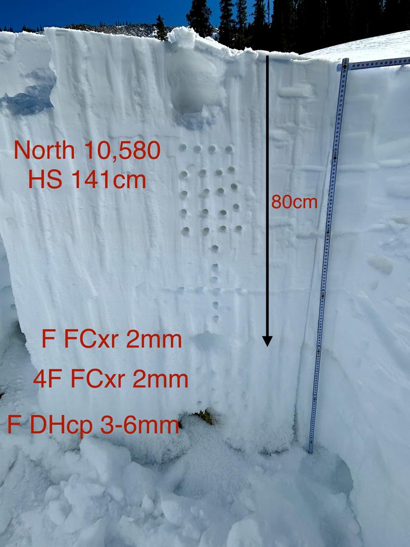
I dug this pit on Sunday on a north-facing slope. The overlying slab is dense, with mostly 4F to 1F snow. A dense slab like this will most likely bridge the weight of a skier, but if you find a shallower snowpack zone, the weight of a human can trigger an avalanche on the weak fist-density facets. A triggered slide would likely take out the entire season's snowpack down to the depth hoar.
Additional Information
Check out the latest UAC podcast with forecaster Brett "Kowboy" Kobernick where he discusses faceted persistent weak layers and how "nobody is immune from getting killed in an avalanche."
Sign up for text alerts to get the most up to date information about changing conditions, road plowing, special avalanche announcements.
Follow us on Instagram @utavy_moab
General Announcements
This forecast is from the U.S.D.A. Forest Service, which is solely responsible for its content. This forecast describes general avalanche conditions and local variations always occur.