Forecast for the Moab Area Mountains

Eric Trenbeath
Issued by Eric Trenbeath on
Friday morning, March 28, 2025
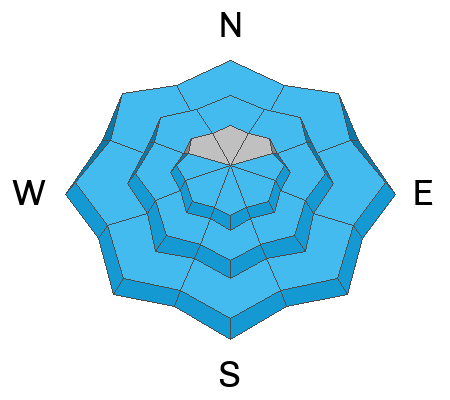
A MODERATE danger for both loose wet, and wet slab avalanches exists on all aspects and elevations with the exception of high elevation, northerly aspects. The lack of direct sunshine will temper the danger somewhat today but after several nights without a refreeze, these types of avalanches remain possible. Rethink slopes where the snow feels punchy and unsupportable and avoid them altogether if they become wet and sloppy.
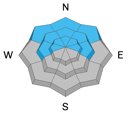
The danger is MODERATE on steep slopes facing W-N-E near and above treeline, and on northerly aspects below. In these areas deep and dangerous, human-triggered avalanches failing on a buried persistent weak layer are possible. The danger is greatest on steep slopes near treeline that face N-NE. While the likelihood of triggering this type of avalanche is decreasing, the consequences remain severe.
Low
Moderate
Considerable
High
Extreme
Learn how to read the forecast here
Special Announcements
Our Spring Campaign is in full swing, and there are two great ways to support forecasting, awareness, and education across Utah: Donate to our Spring Campaign, or Bid on items in our Spring Auction. Every dollar donated helps keep the backcountry community on top.
Construction continues on the Loop Road Mon-Fri. It will be closed near Pack Creek from 8:30-5:30.
Geyser Pass Road: The road is melted down to the dirt.
Grooming Conditions: Grooming is done for the season.
Weather and Snow
6 A.M. Snow and Weather Data
24 Hour Snow: 0" 72 Hour Snow: 0" Season Total Snow: 121" Depth at Gold Basin: 43"
Winds on Pre-Laurel Peak: N/A Temp: 39° F
Weather
Under mostly cloudy skies, temperatures have remained very warm overnight. The first wave in a messy low pressure system will move through the area today bringing mostly cloudy skies, breezy southwest winds, and a slight chance for snow showers this afternoon. High temperatures at 10,000' will be in the mid 40's. Tonight will bring a much needed cool down as the next wave moves through bringing with it a better chance for a few inches of snow. A chance for showers lingers through Saturday with temperatures climbing back up to near 40°F. We'll get another good freeze on Saturday night with partly sunny conditions on Sunday. Next week looks unsettled.
General Conditions
There's an old saying, "a bad day in the mountains beats a good day everywhere else." Today may be the exception. With cloudy and windy conditions, and several nights without a refreeze, you will be hard pressed to find much in the way of redeeming snow surfaces out there. Most surfaces will be punchy and unsupportable. The lack of direct sunshine should diminish the threat of wet avalanche activity but without overnight refreezes, they are still possible. Pay attention to the snow surface and also the layers just below. If the snow is wet, sloppy, and saturated you shouldn't be there. Both wet loose avalanches and wet slabs are possible. Poor snowpack structure remains on slopes that face W-N-E with a well connected slab above weak faceted layers. While this problem is becoming harder to trigger it is still possible for skiers and riders to trigger deep and dangerous avalanches on these slopes. Steep northerly, convex, shallow rocky zones remain the most suspect areas.
Many solar aspects are melting out quickly.
Snowpack and Weather Data
Gold Basin SNOTEL site (10,000')
SNOTEL site near Geyser Pass Winter Trailhead (9600')
Wind Station on Pre-Laurel Peak (11,400')
NWS forecast for the La Sal Mountains.
Recent Avalanches
Dave observed several small wet-loose avalanches in upper Dark Canyon on Tuesday.
See the complete avalanche database here.
Ad
Avalanche Problem #1
Wet Snow
Type
Location
Likelihood
Size
Description
We've had several nights without a refreeze. The lack of direct sunshine will help keep the threat at bay, but human-triggered avalanches involving wet snow remain possible. This includes both loose wet, and wet slab avalanches. Loose wet avalanches are possible on all aspects and elevations with the exception of high elevation northerlies. Signs of instability include rollerballs, pinwheels, and sloppy wet snow. This type of instant feedback is all you need to know that conditions are becoming unstable.
Although harder to predict, wet slab avalanches are also possible. On south through westerly aspects, melt water can pool on buried crusts and faceted layers nearer to the surface increasing the likelihood for wet slab avalanches. There is a higher degree of uncertainty regarding the faceted weak layers on northerlies. It will most likely take more time and warming for any wet slab activity on these slopes. Faceted snow packs can be somewhat unpredictable during rapid warming events. The conservative choice is to let the heat wave play out and wait for a solid refreeze this weekend.
Avalanche Problem #2
Persistent Weak Layer
Type
Location
Likelihood
Size
Description
Poor snowpack structure remains on slopes that face W-N-E. Abundant snowfall in March has built a well connected dense slab 2-3 feet thick above weak layers of faceted snow. These layers have been very slow to heal this season due to relatively shallow snow depths. With each passing day, it is becoming harder to trigger an avalanche on these weak layers. You will not experience cracking and collapsing, and the snowpack will feel strong beneath your skis. Even though the chances of triggering an avalanche are becoming less, we have a structure that most snow professionals won't trust their lives with. The most suspect areas are very steep northerly aspects, and likely trigger points are steep convexities, thin slab margins, and shallow rocky areas. If you are biting off pieces of avalanche terrain, choose smooth planar slopes with clean run-out zones.
Additional Information
Check out the latest UAC podcast with forecaster Brett "Kowboy" Kobernick where he discusses faceted persistent weak layers and how "nobody is immune from getting killed in an avalanche."
Sign up for text alerts to get the most up to date information about changing conditions, road plowing, special avalanche announcements.
Follow us on Instagram @utavy_moab
General Announcements
This forecast is from the U.S.D.A. Forest Service, which is solely responsible for its content. This forecast describes general avalanche conditions and local variations always occur.