Forecast for the Moab Area Mountains

Eric Trenbeath
Issued by Eric Trenbeath on
Sunday morning, March 15, 2020
Increased southerly winds overnight have bumped the avalanche danger back up to CONSIDERABLE and human triggered avalanches are likely on steep wind drifted slopes right around treeline and above that face NW-N-E. Fresh drifts up to a foot deep or more can be found. In some of these same areas, you may be able to trigger a deeper avalanche where fresh wind drifts or older slabs exist over top of layers of weak and sugary, faceted snow. With a strong sun and warming temps, we may see some loose wet activity today and the danger may rise to MODERATE on steep, sun-exposed slopes. Be alert to signs of instability such as roller balls and pinwheels, and stay off of steep slopes that become wet and sloppy.
Low
Moderate
Considerable
High
Extreme
Learn how to read the forecast here
Special Announcements
We know there is a lot of uncertainty regarding the Coronavirus, but the Utah Avalanche Center is planning to continue issuing regular avalanche forecasts into April.
Road Conditions: Some snow and ruts exist on the upper portion of the road. Dirt and mud below.
Grooming: Matt from LUNA groomed yesterday.
Weather and Snow
24 Hour Snow T" Weekly Snow 7" Base Depth in Gold Basin 54" Wind SE 20-30 G50 Temp 26F
Wind, temperature, humidity on Pre Laurel Peak (11,700')
Storm totals at Gold Basin Study Plot (10,000').
Snotel site near Geyser Pass Trailhead (9600').
NWS weather forecast.
Weather: The story is the wind. Strong southerlies have been blowing for the past several days and last night they bumped up another notch. They'll continue to blow today in the 20-25 mph range with gusts in the 30's. Skies will be mostly sunny and high temps will reach the upper 30's. Conditions will remain dry through midweek with the next system currently working its way down the Pacific coast. We should see some more snow Wed-Thu but details remain unclear.
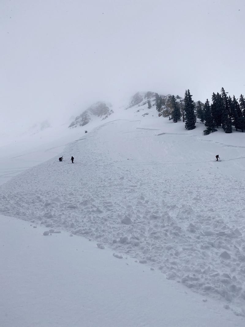
Snowpack: Blown and drifted snow is the standout feature right now. With combined totals of 7"-10" since Wednesday, there has been plenty to blow around. New drifts up to a foot deep or more have formed on leeward slopes right around treeline and above, and they are wider and more connected than you might expect. Windward slopes are mostly scoured and exposed surfaces are firm. Pesky areas where the snowpack is made up almost entirely of loose, weak, faceted snow still exist - primarily on northerly aspects right around treeline and below. Decent turning conditions can be found on sheltered, northerly facing terrain - in wooded areas the underlying snow is soft but weak, in more open areas it's more of a dust on crust situation. Dave Garcia and Ed Grote were up yesterday. Read their observation here.
Blowing and drifting snow over the past few days have created sensitive areas of wind drifted snow.
Recent Avalanches
A party of tourers triggered a significant avalanche yesterday on a steep, NE aspect around 11,000' in upper Gold Basin. Though wind drifted snow appears to be the primary problem, it's possible that this avalanche stepped down into weaker, faceted snow. Human triggered avalanches such as this will continue to be likely today. Here is a preliminary report from Dave Garcia. I'll be up today for a closer look.
Ad
Avalanche Problem #1
Wind Drifted Snow
Type
Location
Likelihood
Size
Description
Strong southerly winds have blown and drifted snow forming fresh drifts on northerly aspects right around treeline and above. Avoid steep slopes that have a smooth, rounded appearance and look for signs of instability such as cracking in the snow surface. In isolated areas, a triggered wind slab could step down into a buried persistent weak layer causing a deeper and more dangerous avalanche.
Avalanche Problem #2
Persistent Weak Layer
Type
Location
Likelihood
Size
Description
Layers of weak, sugary, faceted snow still exist on many north-facing slopes, primarily right around treeline or just below. In isolated areas, fresh drifts or older slabs may exist on top of these buried, persistent weak layers. I would continue to avoid very steep, rocky, or sparsely wooded terrain just below treeline where a triggered avalanche in weak snow could have devastating consequences.
Avalanche Problem #3
Wet Snow
Type
Location
Likelihood
Size
Description
With a strong sun and warming temps today be on the lookout for a rising loose, wet, avalanche danger. The most recent snow is at its most vulnerable when the sun first hits it. Signs of instability include roller balls, pinwheels, and loose snow sluffs. Stay off of steep slopes as they become wet and sloppy.
General Announcements
Check out the avalanche beacon training park at the Geyser Pass Trailhead and practice your rescue skills!
This forecast is from the U.S. Forest Service, which is solely responsible for its content. This forecast describes general avalanche conditions and local variations always occur.