Forecast for the Moab Area Mountains

Eric Trenbeath
Issued by Eric Trenbeath on
Saturday morning, March 14, 2020
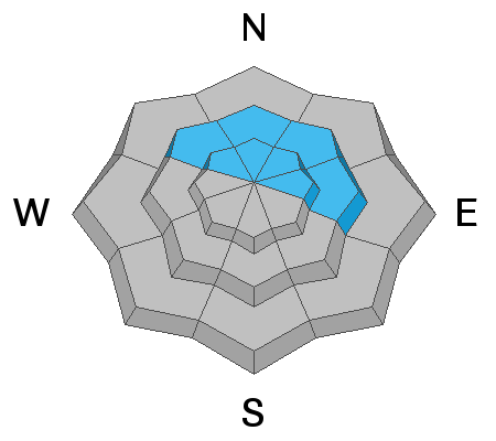
Blowing and drifting snow has created a MODERATE avalanche danger on steep wind loaded slopes right around treeline and above that face NW-N-E. Fresh drifts up to a foot deep can be found. In isolated areas, you may be able to trigger a deeper avalanche where fresh wind drifts or older slabs may be found overlying layers of weak and sugary, faceted snow. You are most likely to encounter this problem on steep, rocky, and sparsely wooded northerly aspects right around treeline and below. Most other terrain has generally LOW danger.
Low
Moderate
Considerable
High
Extreme
Learn how to read the forecast here
Special Announcements
Road Conditions: Some snow and ruts exist on the upper portion of the road. Dirt and mud below.
Grooming: Matt from LUNA will be up grooming today.
Weather and Snow
24 Hour Snow 4" Weekly Snow 7" Base Depth in Gold Basin 54" Wind S 15-20 G30 Temp 24F
Wind, temperature, humidity on Pre Laurel Peak (11,700')
Storm totals at Gold Basin Study Plot (10,000').
Snotel site near Geyser Pass Trailhead (9600').
NWS weather forecast.
Weather: Another unimpressive storm for the La Sals ​​​​​​brought 4" of medium density snow to the mountains. But at least we had wind! Strong southerly winds blew most of the day yesterday averaging 20-30 mph with gusts to 50 along ridge tops before starting to back off around 8:00 p.m last night. They'll continue to blow today in the 15-20 mph range. Skies should gradually clear becoming partly sunny later in the day. High temps in the low 30's. Tomorrow will see mostly sunny skies with high temps near 40. Conditions remain dry until at least Wednesday.
Snowpack: In our travels yesterday Dave Garcia and I observed lots of blowing and drifting snow. With combined totals of 7"-10" since Wednesday, there was plenty to blow around. New drifts up to a foot deep have formed on leeward slopes right around treeline and above. Windward slopes are scoured and exposed surfaces are firm. Pesky areas where the snowpack is made up almost entirely of loose, weak, faceted snow still exist - primarily on northerly aspects right around treeline and below. Decent turning conditions can be found on sheltered, northerly facing terrain - in wooded areas the underlying snow is soft but weak, in more open areas it's more a dust on crust situation.
Ad
Avalanche Problem #1
Wind Drifted Snow
Type
Location
Likelihood
Size
Description
Strong southerly winds have blown and drifted snow forming fresh drifts on northerly aspects right around treeline and above. Avoid steep slopes that have a smooth, rounded appearance and look for signs of instability such as cracking in the snow surface. In isolated areas, a triggered wind slab could step down into a buried persistent weak layer causing a deeper and more dangerous avalanche.
Avalanche Problem #2
Persistent Weak Layer
Type
Location
Likelihood
Size
Description
Layers of weak, sugary, faceted snow still exist on many north-facing slopes, primarily right around treeline or just below. In isolated areas, fresh drifts or older slabs may exist on top of these buried, persistent weak layers. I would continue to avoid very steep, rocky, or sparsely wooded terrain just below treeline where a triggered avalanche in weak snow could have devastating consequences.
General Announcements
Check out the avalanche beacon training park at the Geyser Pass Trailhead and practice your rescue skills!
This forecast is from the U.S. Forest Service, which is solely responsible for its content. This forecast describes general avalanche conditions and local variations always occur.