Forecast for the Moab Area Mountains

Eric Trenbeath
Issued by Eric Trenbeath on
Friday morning, March 13, 2020
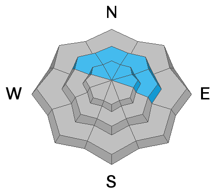
New snow and wind will create a rising hazard and the avalanche danger will likely reach CONSIDERABLE today. Human triggered avalanches involving new and wind drifted snow will become increasingly more likely as the day progresses. Be on the lookout for fresh wind drifts to form on the leeward sides of ridge crests and terrain features on slopes facing the north half of the compass. If we reach accumulations of more than about 6" human triggered avalanches involving the new snow will be possible on steep slopes on all aspects. On isolated, steep, northerly facing slopes below treeline, the new snow load may begin to affect weak, sugary facets deeper in the snowpack. Be alert to changing conditions and scale back your objectives today until we see what happens.
Low
Moderate
Considerable
High
Extreme
Learn how to read the forecast here
Weather and Snow
24 Hour Snow 2" Weekly Snow 5" Base Depth in Gold Basin UK Wind SE 20-25 G30 Temp 31F
Wind, temperature, humidity on Pre Laurel Peak (11,700')
Storm totals at Gold Basin Study Plot (10,000').
Snotel site near Geyser Pass Trailhead (9600').
NWS weather forecast.
Subtropical moisture has moved into the area ahead of a closed mid-level low that will track northeastward through Arizona today. Heavy snowfall rates of 1"-2" an hour will accompany the initial surge and it looks like we could see 5"-8" of snow today. Snowfall should taper off by afternoon with light showers continuing through tonight. Ridgetop SE winds will blow in the 20-25 mph range with 10,000' temps rising into the low 30's. Tomorrow will be cloudy with a chance for continued showers. Things should clear out on Sunday though we remain under SW flow through next week with another low moving down the west coast. In what looks to be a repeat pattern, this system will move inland sometime next Wed-Thu.
Ad
Avalanche Problem #1
Wind Drifted Snow
Type
Location
Likelihood
Size
Description
Moderate to strong southerly winds will blow and drift the new snow. Be on the lookout for fresh drifts to form on the leeward sides of ridge crests and terrain features on upper elevation slopes facing the north side of the compass. Fresh drifts are recognizable by their smooth, rounded appearance and cracking is a sign of instability. Avoid steep slopes with recent deposits of wind drifted snow.
Avalanche Problem #2
New Snow
Type
Location
Likelihood
Size
Description
Dense, heavy, wind-driven snow is conducive to slab formation, and If we see more than about 6" human triggered avalanches involving the new snow will become more likely on steep slopes on all aspects. Pay attention as the snow piles up and look for signs of instability such as cracking in the snow surface.
Avalanche Problem #3
Persistent Weak Layer
Type
Location
Likelihood
Size
Description
Weak, sugary, faceted snow still exists on many north-facing slopes, primarily right around treeline or just below. In isolated areas, the new snow load may begin to affect these buried, persistent weak layers. The steeper, rockier, and more radical the terrain, the more likely you are to find a problem.
General Announcements
Check out the avalanche beacon training park at the Geyser Pass Trailhead and practice your rescue skills!
This forecast is from the U.S. Forest Service, which is solely responsible for its content. This forecast describes general avalanche conditions and local variations always occur.