Forecast for the Moab Area Mountains

Eric Trenbeath
Issued by Eric Trenbeath on
Monday morning, February 3, 2020
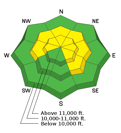
Expect a rising avalanche danger today. Strong southerly winds are blowing and drifting snow and the danger is MODERATE on steep, wind drifted slopes that face W-N-SE. Human triggered avalanches are possible in these areas and the danger will become more widespread throughout the day. If snow totals come in on the high end, the danger could reach CONSIDERABLE by afternoon. Be alert to changing conditions and avoid steep slopes with recent deposits of wind drifted snow.
Low
Moderate
Considerable
High
Extreme
Learn how to read the forecast here
Special Announcements
Are you looking to improve your avalanche skills? We are offering a Backcountry 101: Introduction to Avalanches class on February 15-16 in Moab. Click here to register A huge thanks to Moab Gear Trader for sponsoring this course. Please visit them for all your winter backcountry needs.
New UAC Podcast: The Art of Storytelling Through Film - A Conversation with Trent Meisenheimer check it out HERE.
Road Conditions: The road is plowed but snowpacked. Expect blowing and drifting snow in places.
Grooming report: LUNA's (Lower Utah Nordic Alliance) dedicated groomer Matt Hebberd groomed the lower meadow and set classic track on Saturday.
Weather and Snow
24 Hour Snow 2" Weekly Snow 7" Base Depth in Gold Basin 48" Wind S 45 G70 mph Temp 24F
Weather: Winds are nuking! Since about midnight they have blown in the 40-45 mph range with gusts to 70 mph. The front has yet to arrive on this storm, expect passage sometime this morning. Though we could see periods of heavy snowfall, overall totals look to be fairly meager with only 3"-5" possible. But at least it will be windy! Today may be a good day to get a jump on some of those spring cleaning projects like sorting the sock drawer. Winds will taper off slightly during the day with a chance of snow lingering through tonight. High temps will be in the mid to upper 20's. Cold air will fill in behind the storm with lows tonight dropping to around zero. Cold air will remain through Wednesday, with high temps on Tuesday of around 1o degrees.
Snowpack: I'm afraid the damaging effects of the wind may outweigh the benefits of the new snow. By late afternoon we may begin to see a refresh in the most sheltered areas. South-facing terrain will be a wasteland of sun crusts and wind-blasted surfaces that are stripped right down to the rocks in many areas.
Underneath, the snowpack is also variable. In most areas above about 10,500', the pack is deep and strong with a depth of 4'-5'. But sun and wind-exposed slopes, and rocky areas right around treeline and below have shallower and weaker snow. Whether or not these weaker snowpack areas become unstable will depend on future snow loads.
Wind, temperature, humidity on Pre Laurel Peak (11,700')
Storm totals at Gold Basin Study Plot (10,000').
Snotel site near Geyser Pass Trailhead (9600').
NWS weather forecast
Ad
Avalanche Problem #1
Wind Drifted Snow
Type
Location
Likelihood
Size
Description
Nuking winds will rip into the old snow and transport whatever is available before it is stripped down to the rocks. Add new snow to the mix and we could see sensitive new drifts forming that will be deep enough to knock down and possibly bury a person. With the strong winds, expect drifts to form farther down slope than usual. This factor, combined with the convex nature of much of our terrain, could lure you further down the slope before you trigger an unstable wind slab. Avoid steep slopes with blind break-overs and steep convexities. A triggered wind slab also has the potential to step down into a buried, persistent weak layer, particularly in areas of rocky, extreme terrain, or where the underlying snowpack is shallow and weak.
Avalanche Problem #2
Persistent Weak Layer
Type
Location
Likelihood
Size
Description
Spatial variability in the snowpack is the key phrase right now. Many areas have a deep and strong, underlying snowpack, while wind exposed terrain, and rocky, northerly facing slopes right around treeline and below have a shallower and weaker snowpack. As pointed out by Travis Nauman in this observation, we will want to pay attention to these weaker areas as they become loaded.
We've also been tracking a reactive weak layer on SE-S facing slopes. I'm hoping the warm temps over the weekend have helped put an end to this concern but until I get eyes on it myself, I can't be certain.
General Announcements
My radio interview on KZMU about the history of backcountry skiing in the La Sals, avalanche accidents, and unique snowpack has been saved in perpetuity. You can listen to it here.
Check out the avalanche beacon training park at the Geyser Pass Trailhead and practice your rescue skills!
This forecast is from the U.S. Forest Service, which is solely responsible for its content. This forecast describes general avalanche conditions and local variations always occur.