Forecast for the Moab Area Mountains

Eric Trenbeath
Issued by Eric Trenbeath on
Sunday morning, February 2, 2020
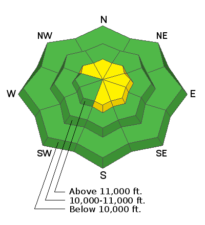
Most terrain offers generally LOW danger. Isolated areas exist where you may be able to trigger an avalanche - primarily on steep, wind loaded slopes at upper elevations that face NW-E-SE. In these areas, the avalanche danger remains MODERATE. Other outlying areas of concern include steep, rocky, radical terrain that has an underlying weak snowpack. With warm temperatures on tap, be alert for loose wet activity on sun-exposed slopes later in the day. With snow and wind in the forecast, expect a rising danger tomorrow.
Low
Moderate
Considerable
High
Extreme
Learn how to read the forecast here
Special Announcements
Are you looking to improve your avalanche skills? We are offering a Backcountry 101: Introduction to Avalanches class on February 15-16 in Moab. Click here to register A huge thanks to Moab Gear Trader for sponsoring this course. Please visit them for all your winter backcountry needs.
New UAC Podcast: The Art of Storytelling Through Film - A Conversation with Trent Meisenheimer check it out HERE.
Road Conditions: The road is plowed but snowpacked.
Grooming report: LUNA's (Lower Utah Nordic Alliance) dedicated groomer Matt Hebberd groomed the lower meadow and set classic track yesterday.
Weather and Snow
24 Hour Snow 0" Weekly Snow 5" Base Depth in Gold Basin 48" Wind S 20-25 G35 mph Temp 28F
Weather: Skies are clear and it's warm up there with overnight temps staying above freezing in many locations. Southerly winds started ramping up around 3:00 a.m. and will continue to average 20 mph along ridge tops with gusts in the 30's, a downgrade from yesterday's forecast. Skies will be sunny with high temps near 40F. Clouds and winds will increase tonight as a powerful storm system moves into the region. I fear it will be more huff and puff than fluff for us, as once again we appear not to be on the favored storm track. Snow should begin sometime tomorrow morning with what looks to me like 3"-5" possible. Southwest winds will crank in the 30-35 mph range with gusts to 50.
Snowpack: A mixed bag of snow conditions can be found out there right now. Yesterday's sun and warm temps really cooked things and without a solid refreeze, sun-exposed slopes will be punchy today. Wind-exposed alpine terrain has taken a hit from the wind, and you will have to seek sheltered locations below treeline to find soft snow. Travis Nauman and company were out yesterday and sent in this report.
Underneath, the snowpack is also variable. In most areas above about 10,500', the pack is deep and strong with a depth of 4'-5'. But sun and wind-exposed slopes, and rocky areas right around treeline and below have shallower and weaker snow. Whether or not these weaker snowpack areas become unstable will depend on future snow loads.
Wind, temperature, humidity on Pre Laurel Peak (11,700')
Storm totals at Gold Basin Study Plot (10,000').
Snotel site near Geyser Pass Trailhead (9600').
NWS weather forecast
Ad
Avalanche Problem #1
Wind Drifted Snow
Type
Location
Likelihood
Size
Description
In spite of the increasing winds, there is very little loose snow available for transport but older, isolated wind slabs are still scattered about the high country. Triggering one is becoming much less likely but remain on the lookout for smooth rounded pillows that feel or sound hollow like a drum. You are most likely to encounter a wind slab on the lee side of a terrain feature on an upper elevation slope that faces NE-E-SE but cross-loading has affected slopes further around the compass. Carefully evaluate steep terrain for signs of wind loading.
Avalanche Problem #2
Persistent Weak Layer
Type
Location
Likelihood
Size
Description
Spatial variability in the snowpack is the key phrase right now. Many areas have a deep and strong, underlying snowpack, while wind exposed terrain, and rocky, northerly facing slopes right around treeline and below have a shallower and weaker snowpack. As pointed out by Travis Nauman in his observation, we will want to pay attention to these weaker areas as they become loaded. For now, they shouldn't pose much of a problem though an outlying concern would be triggering an isolated wind slab on top of this weak, underlying snow.
We've also been tracking a reactive weak layer on SE-S facing slopes. I'm thinking the warm temps yesterday and today will start to put an end to this concern, but I'd like to see a good, hard refreeze before I feel good about it.
General Announcements
My radio interview on KZMU about the history of backcountry skiing in the La Sals, avalanche accidents, and unique snowpack has been saved in perpetuity. You can listen to it here.
Check out the avalanche beacon training park at the Geyser Pass Trailhead and practice your rescue skills!
This forecast is from the U.S. Forest Service, which is solely responsible for its content. This forecast describes general avalanche conditions and local variations always occur.