Forecast for the Moab Area Mountains

Dave Garcia
Issued by Dave Garcia on
Sunday morning, February 16, 2025
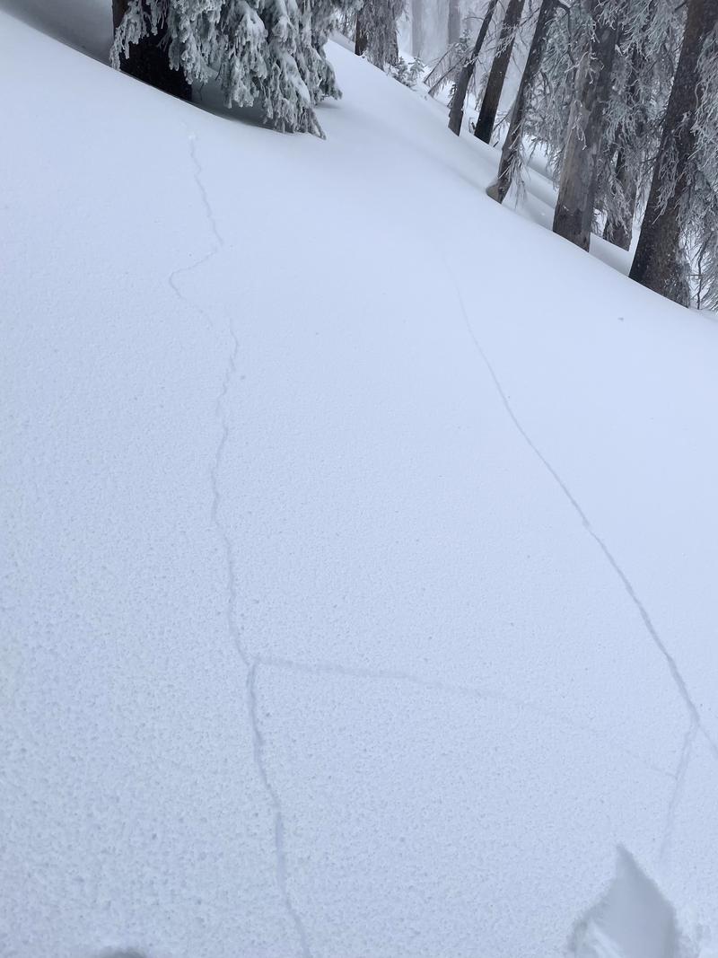
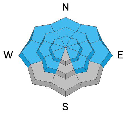
The avalanche danger is CONSIDERABLE on all slopes that face W-N-SE. Human-triggered avalanches involving the recent storm snow and deeper persistent weak layers are LIKELY. The recent snow has formed a cohesive slab and is stressing widespread buried weak layers to their breaking point. Avalanches failing on buried facets can be triggered remotely. Stay off of and out from under slopes steeper than 30 degrees in any terrain that faces W-N-SE.
The danger is MODERATE on all slopes that face SW-S and human-triggered slab avalanches involving the new snow are POSSIBLE. Careful snowpack evaluation is required if you are poking into steep terrain on these aspects.
Low
Moderate
Considerable
High
Extreme
Learn how to read the forecast here
Special Announcements
The final report for the fatal avalanche in East Bowl of Silverfork in the Salt Lake Area Mountains is complete and available here. Our sincere condolences to all who are affected by this tragedy.
Geyser Pass Road: Deep and drifted snow cover the road with plowing not expected until Tuesday. A few vehicles made it up yesterday, and a few got stuck. 4X4 with high clearance is required, and chains may be necessary.
Grooming Conditions: Gavin groomed on Saturday out to Gold Basin and Geyser Pass
Weather and Snow
6 A.M. Snow and Weather Data
24 Hour Snow: 0" 72 Hour Snow: 15" Season Total Snow: 80" Depth at Gold Basin: 41"
Winds on Pre-Laurel Peak: N/A Temp: 10° F Percent of Normal (SWE): 75%
Weather
Under clear skies, it is 10° F in Gold Basin this morning. Pre-Laurel is rimed up, but nearby wind stations show westerly winds in the moderate range. Today the wind will remain out of the west and is forecast to average 10 MPH. High temperatures will reach the mid to upper 20s° F. We will see increasing cloud cover today as a storm brings snowfall to points north. Light snow flurries will move into our region tomorrow and last through Tuesday morning. This is a weak system and should only leave us with a trace to two inches of snow. Another chance for light snow comes Thursday into Friday.
General Conditions
15 inches of recent storm snow provides the best skiing and riding conditions of the season. The new snow is supportive, surfy, fast, and super fun. We ran into many folks yesterday, out and about enjoying the new snow. The skiing is great, but the new snow came in with 2.5” of SWE (snow water equivalent) and formed a cohesive slab on top of widespread weak, faceted snow. Our party experienced multiple audible collapses, complete with shooting cracks. Other parties we talked with reported the same. Brian Sparks broke trail yesterday morning and also reported cracking and collapsing in his observation. Widespread cracking and collapsing is a huge red flag indicator that the snowpack is unstable. Storm slab avalanches can fail at the new snow/old snow interface and any avalanche has the potential to step down to more deeply buried weak layers. Backcountry travelers should continue to avoid avalanche terrain on any slope that has poor snowpack structure.
Brian Sparks' photo of shooting cracks, a big red flag of unstable snow.
Snowpack and Weather Data
Gold Basin SNOTEL site (10,000')
SNOTEL site near Geyser Pass Winter Trailhead (9600')
Wind Station on Pre-Laurel Peak (11,400')
NWS forecast for the La Sal Mountains.
Recent Avalanches
Ad
Avalanche Problem #1
Persistent Weak Layer
Type
Location
Likelihood
Size
Description
The writing is on the wall, widespread collapsing and cracking tells us all we need to know. The snowpack is unstable, and backcountry travelers should avoid avalanche terrain on all slopes that face W-N-SE. Don't try and outsmart this problem; you will get burned. In our travels yesterday, we observed failures at the new snow/old snow interface and also into more deeply buried faceted layers. Any avalanche triggered today has the potential to break deep. These slides will be unmanageable and large enough to bury a human. Additionally, below treeline terrain is especially weak, use extra caution while traveling in and out of drainage bottoms and give a wide berth to terrain traps and gullies.
Solar aspects that face southwest and south have a different structure. Slab avalanches involving the new snow remain possible. These can fail on hard slick crusts formed by the long dry spell. In some cases, the couple inches of snow that fell on 2/11 (see the photo below) may still be preserved on some solar aspects, and in other cases it was destroyed by strong southerly winds. This snow quickly faceted and then was buried by the recent storm. If you are poking into steep slopes on solar aspects, you need to dig down and make sure this layer doesn't exist on the slope you want to ski.
This detailed pit from Chris Benson on 2-14 shows the current structure on a NE aspect near treeline. Water totals at the end of the storm are 2.4" SWE.
Avalanche Problem #2
New Snow
Type
Location
Likelihood
Size
Description
Slab avalanches involving the recent storm snow are likely today on any steep slope that held snow prior to the storm. These avalanches could be 1-2 feet deep. Any avalanche triggered in the storm snow has the potential to step down into buried persistent weak layers causing a deeper and much more dangerous avalanche.
Strong southerly winds accompanied the recent storm. Blowing and drifting of the new snow formed slabs 2 to 3 feet deep on the leeward side of ridge lines and terrain features near the treeline and above. Expect these drifts to be sensitive to the weight of a skier or rider. Recent drifts will mostly be found on the north side of the compass and this is terrain you should be avoiding anyway today.
Additional Information
Check out the latest edition of the UAC podcast with Moab forecaster Dave Garcia where he talks about the challenges of forecasting for our remote and isolated range with limited information.
Sign up for text alerts to get the most up to date information about changing conditions, road plowing, special avalanche announcements.
Follow us on Instagram @utavy_moab
General Announcements
This forecast is from the U.S.D.A. Forest Service, which is solely responsible for its content. This forecast describes general avalanche conditions and local variations always occur.