Forecast for the Moab Area Mountains

Eric Trenbeath
Issued by Eric Trenbeath on
Tuesday morning, February 18, 2025
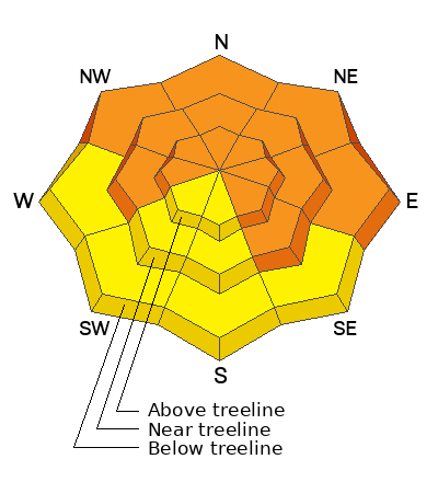
The avalanche danger remains CONSIDERABLE on steep slopes near and above treeline that face W-N-SE, and on all slopes facing the north half of the compass below. Deep and deadly human-triggered avalanches failing on buried persistent weak layers are LIKELY. Avalanches can be triggered remotely or from a distance. Stay off of and out from under slopes steeper than 30 degrees.
All other terrain has a MODERATE danger and human-triggered avalanches failing on a buried persistent weak layer are POSSIBLE.
Conservative decision-making remains essential for backcountry travel today.
Low
Moderate
Considerable
High
Extreme
Learn how to read the forecast here
Special Announcements
Geyser Pass Road: Grand County is headed up to plow this morning. The gate will be closed while plowing is in progress.
Grooming Conditions: Gavin groomed on Saturday out to Gold Basin and up to Geyser Pass.
Weather and Snow
6 A.M. Snow and Weather Data
24 Hour Snow: 0" 72 Hour Snow: 0" Season Total Snow: 80" Depth at Gold Basin: 40"
Winds on Pre-Laurel Peak: WNW 15-20 G 29 Temp: 19° F Percent of Normal (SWE): 72%
Weather
Look for mostly sunny skies today. West northwest winds will average 10 mph with gusts to 20 mph. High temperatures will be in the low to mid 20's.
Wednesday brings increasing clouds ahead of a weak storm system that will favor the north Thursday - Friday. High pressure builds over the weekend.
General Conditions
Great skiing and riding conditions still exist but it's getting harder to find trackless snow that isn't in avalanche terrain. Late last week, the mountains received 15 inches of snow at close to 2.5 inches of Snow Water Equivalent and the weak, pre-existing snowpack responded in kind. Cracking and collapsing have been widespread, and instability tests are very reactive. Wind loaded, northerly aspects near and above treeline are the most dangerous, but unstable conditions have been observed around the compass. For more on the state of things, see Dave's video below.
Snowpack and Weather Data
Gold Basin SNOTEL site (10,000')
SNOTEL site near Geyser Pass Winter Trailhead (9600')
Wind Station on Pre-Laurel Peak (11,400')
NWS forecast for the La Sal Mountains.
Recent Avalanches
Ad
Avalanche Problem #1
Persistent Weak Layer
Type
Location
Likelihood
Size
Description
Widespread cracking and collapsing was observed over the weekend. This is a huge red flag and should tell us everything we need to know. On northerly aspects, the snowpack is hair-trigger and just waiting for the weight of a human to come along and tip the scales. Most failures are happening on the 2/11 weak layer just beneath the new snow but some failures are occurring on more deeply buried facets. Any avalanche triggered today has the potential to be deep and deadly. Avalanches can be triggered remotely or from a distance. Stay out from underneath steep slopes. Additionally, below treeline terrain is especially weak, use extra caution while traveling in and out of drainage bottoms and give a wide berth to terrain traps and gullies.
Slopes that face southwest and south are less sensitive, but it is still a tricky situation. These slopes hold layers of alternating crusts and facets. Touring parties are reporting collapsing on these aspects. Furthermore, the 2/11 weak layer was destroyed by strong winds on some of these slopes, and it is preserved and reactive on others. This is sort of like walking through a field of land mines and hoping you make it. When things get complicated the simple solution is to make conservative terrain choices.
The snowpit below is a north facing slope that illustrates the recent storm slab failing on the 2/11 weak layer.
Avalanche Problem #2
Wind Drifted Snow
Type
Location
Likelihood
Size
Description
Pesky winds continue to blow and drift snow at upper elevations and building slabs on slopes the face primarily NW-N-E-SE. Slabs of wind drifted snow may be sensitive to the weight of a skier or rider, but much more concerning is the likelihood that they will step down into buried. weak, faceted layers. For this reason alone, these slopes should be avoided.
The photo below shows drifted slopes that are primed for avalanches and just waiting for a trigger such as a skier.
Additional Information
Check out the latest edition of the UAC podcast with Moab forecaster Dave Garcia where he talks about the challenges of forecasting for our remote and isolated range with limited information.
Sign up for text alerts to get the most up to date information about changing conditions, road plowing, special avalanche announcements.
Follow us on Instagram @utavy_moab
General Announcements
This forecast is from the U.S.D.A. Forest Service, which is solely responsible for its content. This forecast describes general avalanche conditions and local variations always occur.