Forecast for the Moab Area Mountains

Eric Trenbeath
Issued by Eric Trenbeath on
Saturday morning, February 15, 2025
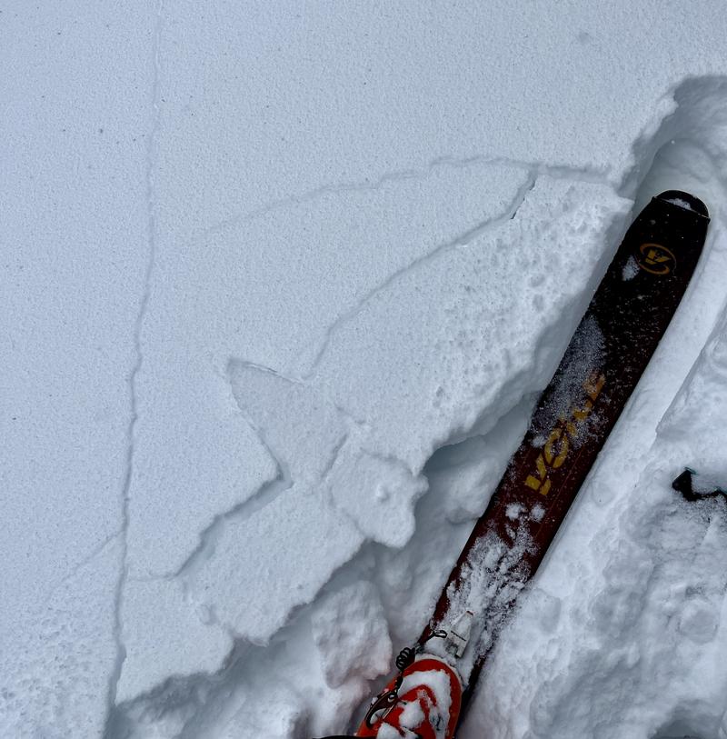
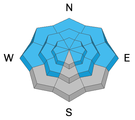
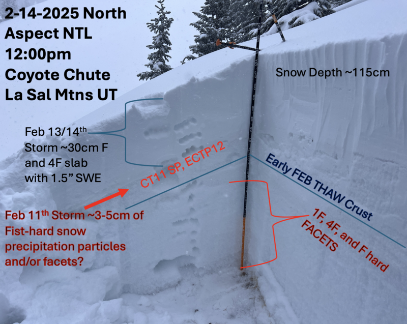
The avalanche danger is HIGH on steep, wind loaded slopes near treeline and above that face NW-N-NE-E, and human triggered avalanches are certain. In these areas, avalanches involving new and wind drifted snow have a high likelhood of stepping down into buried persistent weak layers causing deeper and much more dangerous avalanches. Stay off of and out from under slopes steeper than 30 degrees.
A CONSIDERABLE avalanche danger exists on all other apects and elevations. Human triggered avalanches involving slabs of recent storm snow are likely, while avalanches breaking into a persistent weak layer are possible. Steep, northerly facing slopes have the highest probability for failure on a buried weak layer.
Backcountry travelers should avoid all avalanche terrain today. This means staying off of, and out from under slopes steeper than 30 degrees.
Low
Moderate
Considerable
High
Extreme
Learn how to read the forecast here
Avalanche Warning
What- The avalanche danger for the warning area is HIGH today and may rise to EXTREME in some areas this weekend.
When- Very dangerous avalanche conditions are expected through the weekend.
Where- For all the mountains of Utah and Southeast Idaho, including the Wasatch Range, Bear River Range, Uinta Mountains, Wasatch Plateau, Manti Skyline, the La Sal and Abajo Mountains, the Tushar Range....
Impacts- Heavy snow and drifting by strong winds have created widespread areas of unstable snow and very dangerous avalanche conditions at all elevations. Natural and human-triggered avalanches are likely. People should avoid travel in all avalanche terrain and keep out of avalanche runouts. This means you should stay off of and out from under slopes steeper than 30 degrees.
Special Announcements
The final report for the fatal avalanche in East Bowl of Silverfork in the Salt Lake Area Mountains is complete and available here. Our sincere condolences to all who are affected by this tragedy.
Geyser Pass Road: Deep and drifted snow cover the road with plowing not expected until Tuesday. A few vehicles made it up yesterday, and a few got stuck. 4X4 with high clearance is required, and chains may be necessary.
Grooming Conditions: Trails are covered in deep snow.
Weather and Snow
6 A.M. Snow and Weather Data
24 Hour Snow: 7" 72 Hour Snow: 15" Season Total Snow: 80" Depth at Gold Basin: 42"
Winds on Pre-Laurel Peak: WNW 2-5 Temp: 22° F Percent of Normal (SWE): 73%
Weather
Snow continued to fall throughout the day yesterday bringing storm totals up to 15 inches or more with an impressive 2.4 inches of Snow Water Equivalent (SWE). Southwest winds came on strong early in the storm and gradually tapered off during the day yesterday before shifting to the west northwest. This morning they are remarkably light. They should pick up again today while we remain under a moist, northwest flow. A chance for showers remains through the morning. Under clear skies tonight, temperatures will crater into the single digits. Tomorrow looks like a beautiful winter day in the mountains. Another system moves through on Monday with most of the energy staying north.
General Conditions
That was a very welcome return to winter! Even the desert got a good soaking and the snowline dropped to around 6500'. In our travels yesterday we observed several red flags including heavy snowfall, wind blown snow, cracking and collapsing, and poor snowpack structure. Poor visibility prevented us from being able to have a good look around but by and large, instabilities seemed confined to the dense, upside down new snow with failures at the new snow/old snow interface. That said, the underlying snowpack structure is very weak, and with nearly 2.5 inches of water weight, we are teetering on the brink. Any avalanche triggered has the very real potential to step down into this weak snow, particularly on steep, northerly aspects, but all slopes that held snow before this storm are suspect. Chris Benson was also out and about yesterday and shared his findings in this excellent observation.
We observed lots of cracking, and collapsing in the snow surface yesterday. Steep slopes were ready to go.
Snowpack and Weather Data
Gold Basin SNOTEL site (10,000')
SNOTEL site near Geyser Pass Winter Trailhead (9600')
Wind Station on Pre-Laurel Peak (11,400')
NWS forecast for the La Sal Mountains.
Recent Avalanches
Ad
Avalanche Problem #1
Persistent Weak Layer
Type
Location
Likelihood
Size
Description
Although instabilities yesterday were mainly observed within the new snow, by far the most dangerous situation is for triggering a storm snow avalanche and having it step down into a buried persistent weak layer, possibly failing at the ground level. On northerly aspects the entire snowpack has faceted through, and prevailing southerly winds increased the load by drifting new snow on top of this poor snowpack structure. Dangerous, human triggered avalanches are all but certain in these areas. On sunny slopes that still retained snow, the structure is also weak, particularly on slopes that have a west or easterly component to their aspect. These areas will have to be assumed guilty until proven otherwise. Avoidance of avalanche terrain is the only recommended strategy at this time.
This detailed pit from Chris Benson shows the current structure on a NE aspect near treeline.
Avalanche Problem #2
New Snow
Type
Location
Likelihood
Size
Description
Slab avalanches involving the recent storm snow are likely today on any steep slope that held snow prior to the storm. These avalanches could be 1-2 feet deep. Any avalanche triggered in the storm snow has the potential to step down into buried persistent weak layers causing a deeper and much more dangerous avalanche. Travel advice remains the same, avoid slopes steeper than 30 degrees on all aspects and elevations today.
Additional Information
Check out the latest edition of the UAC podcast with Moab forecaster Dave Garcia where he talks about the challenges of forecasting for our remote and isolated range with limited information.
Sign up for text alerts to get the most up to date information about changing conditions, road plowing, special avalanche announcements.
Follow us on Instagram @utavy_moab
General Announcements
This forecast is from the U.S.D.A. Forest Service, which is solely responsible for its content. This forecast describes general avalanche conditions and local variations always occur.