Forecast for the Moab Area Mountains

Eric Trenbeath
Issued by Eric Trenbeath on
Friday morning, February 14, 2025
Dangerous avalanche conditions exist with a continued rise in danger expected throughout the day!
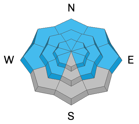
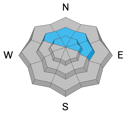
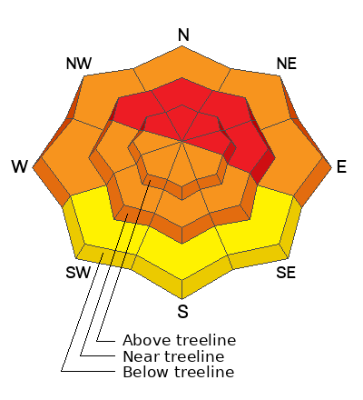
The avalanche danger is CONSIDERABLE on all aspects near and above treeline and on northerly aspects below. Human triggered avalanches are likely and natural avalanches are possible in these areas. With continued snowfall and strong winds, I expect the danger to reach HIGH on all steep, notherly aspects near treeline and above. Travel in avalanche terrain is not recommended today. Avoid being on or under slopes steeper than 30 degrees.
Low
Moderate
Considerable
High
Extreme
Learn how to read the forecast here
Avalanche Warning
What- The avalanche danger for the warning area is HIGH today and may rise to EXTREME in some areas this weekend.
When- Very dangerous avalanche conditions are expected through the weekend.
Where- For all the mountains of Utah and Southeast Idaho, including the Wasatch Range, Bear River Range, Uinta Mountains, Wasatch Plateau, Manti Skyline, the La Sal and Abajo Mountains, the Tushar Range....
Impacts- Heavy snow and drifting by strong winds have created widespread areas of unstable snow and very dangerous avalanche conditions at all elevations. Natural and human-triggered avalanches are likely. People should avoid travel in all avalanche terrain and keep out of avalanche runouts. This means you should stay off of and out from under slopes steeper than 30 degrees.
Special Announcements
We are deeply saddened to report an avalanche fatality in East Bowl of Silverfork in the Salt Lake Area Mountains on Saturday. We will provide a full accident report in the coming days.
Check out the latest edition of the UAC podcast with Moab forecaster Dave Garcia where he talks about the challenges of forecasting for our remote and isolated range with limited information.
Geyser Pass Road: Expect a few inches of new and drifted snow with deteriorating condtions throughout the day. 4wd recommended.
Grooming Conditions: Trails are covered in fresh snow.
Weather and Snow
6 A.M. Snow and Weather Data
24 Hour Snow: 8" 72 Hour Snow: 10" Season Total Snow: 73" Depth at Gold Basin: 35"
Winds on Pre-Laurel Peak: SE 15-20 G 30 Temp: 26° F Percent of Normal (SWE): 73%
Weather
We seem to be experiencing a lull in the action and snow totals are a bit all over the place with 6-8 inches in Gold Basin at just under an inch of water, and only a couple inches of new snow being reported near the Geyser Pass Trailhead. Not exactly the blowout we were hoping for but we should pick up some more today. Steady snow fell between 6:00 p.m. and about 3:00 a.m. overnight accompanied by strong southerly winds gusting to 40 mph along ridge tops. We should see continued snowfall today and lingering into tonight with models showing another 6-10 inches possible. Southwest winds will continue to blow in the moderate to strong range along ridgetops, and high temperatures will be in the low 20's. By Saturday the flow shifts to the northwest where we'll remain under mostly cloudy skies with a chance for snow.
General Conditions
We haven't yet tipped the scales for a full blown avalanche cycle but the new snow and wind alone have created dangerous avalanche conditions with our weak and faceted snowpack. Any further increase in danger will depend on what happens out there today with continued wind and snowfall. Pay attention to how the new snow is behaving - look for cracking in the snow surface and be suspicious of any steep slope that has more than about 6 inches of new snow. If you experience any collapsing or whumphing you are affecting buried weak layers, a sure sign that deeper, more dangerous avalanches are likely.
Snowpack and Weather Data
Gold Basin SNOTEL site (10,000')
SNOTEL site near Geyser Pass Winter Trailhead (9600')
Wind Station on Pre-Laurel Peak (11,400')
NWS forecast for the La Sal Mountains.
Recent Avalanches
Ad
Avalanche Problem #1
Persistent Weak Layer
Type
Location
Likelihood
Size
Description
After the prolonged dry spell, most of the snow left on the ground has become weak and faceted creating an unstable base for any load of snow. On northerly aspects the entire snowpack has faceted through, and prevailing southerly winds will continue to increase the load by drifting new snow on top of this poor snowpack structure. Dangerous, human triggered avalanches will become increasing more likely in these areas. On sunny slopes that still retained snow, the structure is also weak, particularly on slopes that have a west or easterly component to their aspect. These areas will have to be assumed guilty until proven otherwise. Avalanches are most likely to fail on persistent weak layers near the surface first, but as the load increases, avalanches will have the potential to step down to the ground. Avoidance of avalanche terrain is the only recommended strategy at this time.
Photo illustrates the weak structure I found on a north aspect around 10,500' earlier in the week.
Ryan Huels took this photo of weak snow on a southwest aspect.
Avalanche Problem #2
New Snow
Type
Location
Likelihood
Size
Description
Avalanches involving the new snow will grow increasingly more likely today on any steep slope that held snow prior to the storm. Pay attention to how the new snow is behaving - look for cracking in the snow surface and be suspicious of any steep slope that has more than about 6 inches of new snow. If you experience any collapsing or whumphing you are affecting buried weak layers, a sure sign that deeper, more dangerous avalanches are likely.
Avalanche Problem #3
Wind Drifted Snow
Type
Location
Likelihood
Size
Description
Areas with wind drifted snow will compound the danger by increasing the stress in buried persistent weak layers. Drifting is most likely to occur on steep slopes facing NW-N-NE-E near treeline and above, and theses slopes should simply be avoided.
Additional Information
Sign up for text alerts to get the most up to date information about changing conditions, road plowing, special avalanche announcements.
Follow us on Instagram @utavy_moab
General Announcements
This forecast is from the U.S.D.A. Forest Service, which is solely responsible for its content. This forecast describes general avalanche conditions and local variations always occur.