Check out our Holiday Auction - Sign Up for the Utah Snow and Avalanche Workshop (USAW)

Forecast for the Moab Area Mountains

Dave Garcia
Issued by Dave Garcia on
Wednesday morning, December 28, 2022
Very dangerous avalanche conditions exist in the backcountry today as a powerful storm continues to hit the La Sals.
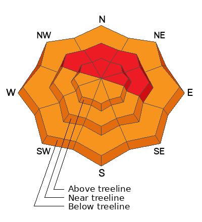
A HIGH avalanche danger exists on all slopes that face NW-N-E near treeline and above for triggering an avalanche on a buried persistent weak layer. Heavy snow and strong winds have overloaded this weak layer creating very dangerous conditions. Human triggered avalanches are very likely today on these slopes. A CONSIDERABLE danger exists for triggering an avalanche on this buried PWL on most other slopes and human triggered avalanches are likely. There is a CONSIDERABLE danger of triggering avalanches in the new snow on all steep slopes at all elevations.
Conditions in the backcountry are complex and dangerous. Travel in avalanche terrain is not recommended. Keep it simple today and avoid all steep slopes.
Low
Moderate
Considerable
High
Extreme
Learn how to read the forecast here
Special Announcements
Didn’t get what you want for Christmas? Do your loved ones simply give you money for the holidays and say “Go buy something for yourself?” Support the UAC and get a great gift for yourself or your loved one at our Holiday Auction. The auction closes at 8:00 PM MT on January 2, 2023.
As the end of the year approaches, please consider a donation to the UAC to support avalanche forecasting.
Road Conditions: The road is not plowed and driving will be difficult today. Good clearance and 4 wheel drive and chains are recommended.
Grooming: Trails were groomed Friday, but will be buried by the new snow today.
Weather and Snow
24 Hour Snow 13" 72 Hour Snow 13" Season Total Snow 93" Base Depth at Gold Basin 50"
Winds on Pre Laurel Peak SSW 22 G 35 Temp 24F
Weather
Thirteen inches of snow has fallen so far at Gold Basin. Snow will continue throughout the day with another 6-8 inches stacking up in the next 12 hour period. Winds will blow 15 mph out of the West with gusts up to 30 today. Snow will taper off tonight. Look for a break in the action on Thursday as the flow turns Northwesterly bringing cold temperatures and partial clearing. The next system arrives on Friday, bringing light accumulations to the La Sals. A SW flow returns for the weekend giving us a good chance for big snow totals on Saturday and Sunday.

General Conditions Riding conditions should be great today. The initial foot of snow came in dense at 1.9" of water. We should stack up another 8 inches of lower density snow today as the storm continues. We will be enjoying about 20 inches of right side up pow by the end of today. Heavy snow combined with strong winds will create dangerous avalanche conditions in the backcountry. A buried persistent weak layer exists on almost all aspects in the La Sal range. Over two inches of water weight plus blowing and drifting snow will reawaken this weak layer. Natural avalanches failing on this weak layer are likely today and human triggered avalanches are very likely. It will also be possible to trigger avalanches in the new snow failing on the old snow surface.
If you're getting out in the backcountry please let us know what you are seeing by submitting an observation . Here are the most recent observations.
Check out my fieldwork from Monday and Tuesday showing a lay of the land before the incoming storm.

Snowpack and Weather Data
Gold Basin Storm Stake (10,000')
Gold Basin SNOTEL site (10,000')
SNOTEL site near Geyser Pass Winter Trailhead (9600')
Wind Station on Pre-Laurel Peak (11,400')
NWS forecast for the La Sal Mountains.
Recent Avalanches
The last observed avalanche was on Thursday, Dec 22. Here is a complete list of avalanches in the La Sals.
Ad
Avalanche Problem #1
Persistent Weak Layer
Type
Location
Likelihood
Size
Description
A persistent weak layer of faceted snow that developed during the cold dry period in mid November exists on almost all aspects and elevation bands in the La Sal range. The buried PWL does not exist below treeline (BTL) on slopes that face SW-S-SE. Very dangerous avalanche conditions exist on any slope that harbors this buried PWL. The storm has overloaded the buried weak layer and will likely produce natural avalanches on slopes that face NW-N-E. Strong winds associated with the storm have complicated this problem. Wind drifted snow has put additional weight on these buried weak layers stressing them to their breaking point. Any avalanche triggered in a fresh wind drift has the potential to step down and trigger a more dangerous and deep avalanche failing on a buried PWL. Human triggered avalanches are very likely today, and travel in avalanche terrain is not recommended. Stick to low angle slopes with no steep terrain above you.
Avalanche Problem #2
New Snow
Type
Location
Likelihood
Size
Description
Today there is a danger of triggering avalanches in the new snow in the the form of storm slab avalanches and dry loose avalanches. The initial 13 inches came in heavy with 1.9" SWE. This has likely created a slab within the new snow. Look for soft slab avalanches in steep sheltered terrain during the storm. These avalanches are likely to be triggered in the steepest part of a starting zone or on convex rollovers. As more snow stacks up, dry loose avalanches will also be possible. This type of avalanche can pick up speed quickly and knock you off your feet. Small dry loose avalanches can become more dangerous around terrain traps. Avoid steep and complex terrain.
Additional Information
General Announcements
This forecast is from the U.S.D.A. Forest Service, which is solely responsible for its content. This forecast describes general avalanche conditions and local variations always occur. This forecast will be updated by 7:30 tomorrow morning.