Check out our Holiday Auction - Sign Up for the Utah Snow and Avalanche Workshop (USAW)

Forecast for the Moab Area Mountains

Dave Garcia
Issued by Dave Garcia on
Tuesday morning, December 27, 2022
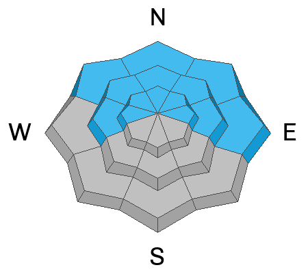
Today you will find a MODERATE danger for human triggered avalanches failing on a buried persistent weak layer on steep slopes that face W-N-E. It is still possible to trigger deep, dangerous avalanches large enough to bury a person. The greatest danger exists on Northerly facing slopes that have been previously loaded by thick slabs of wind drifted snow. Most south facing terrain has generally LOW danger.
Heads Up! A powerful winter storm arrives this evening. Heavy snow and wind will create dangerous avalanche conditions in the backcountry.
Low
Moderate
Considerable
High
Extreme
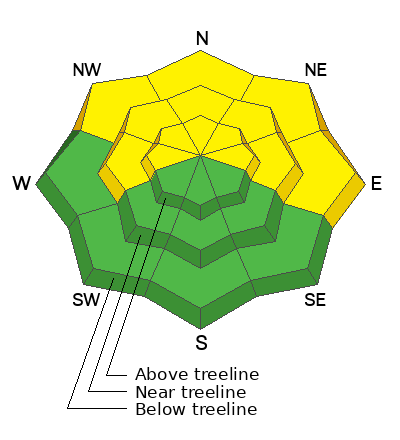
Learn how to read the forecast here
Special Announcements
Didn’t get what you want for Christmas? Do your loved ones simply give you money for the holidays and say “Go buy something for yourself?” Support the UAC and get a great gift for yourself or your loved one at our Holiday Auction. The auction closes at 8:00 PM MT on January 2, 2023.
As the end of the year approaches, please consider a donation to the UAC to support avalanche forecasting.
Road Conditions: The road is snowpacked and slick. AWD and good tires are required.
Grooming: LUNA groomed all trails on Friday. Thanks John!
Weather and Snow
24 Hour Snow 0" 72 Hour Snow 0" Season Total Snow 80" Base Depth at Gold Basin 37"
Winds on Pre Laurel Peak S 25 G 36 Temp 32F
Weather
Today we can expect warm temperatures and increasing clouds ahead of the storm that arrives this evening. Winds will blow out of the SW at 20-25 mph. Light snow showers will begin late this afternoon. The real action should pick up around 8 PM with the heaviest snowfall occurring between midnight and 6 AM. Snowfall will continue Wednesday morning and this storm should give us about 20 inches of snow with 2 inches of water with higher amounts possible. Light snow showers will continue Thursday and Friday with little accumulation before another promising storm moves in this weekend.

General Conditions
The snow surface has taken hit over the past several days and you can expect to find a combination of crusted, scoured, and alternately wind loaded slopes near and above treeline. "Loud powder" exists on open slopes in the form of surface hoar. You can still find soft snow in sheltered areas in the trees. Recent wind loading has kept the pressure on a buried persistent weak layer of faceted snow, particularly on steep, northerly aspects near treeline and above, and human triggered avalanches 2'-4' deep remain possible in these areas.
If you're getting out in the backcountry please let us know what you are seeing by submitting an observation . Here are the most recent observations.

Snowpack and Weather Data
Gold Basin Storm Stake (10,000')
Gold Basin SNOTEL site (10,000')
SNOTEL site near Geyser Pass Winter Trailhead (9600')
Wind Station on Pre-Laurel Peak (11,400')
NWS forecast for the La Sal Mountains.
Recent Avalanches
The last observed avalanche was on Thursday, Dec 22. Here is a complete list of avalanches in the La Sals.
Ad
Avalanche Problem #1
Persistent Weak Layer
Type
Location
Likelihood
Size
Description
A persistent weak layer of faceted snow that developed during the cold dry period in mid November still exists on W-N-E aspects. Slopes facing NW-N-E, near treeline and above, are the most suspect. In these areas wind drifted snow has built thick slabs on top of the weak layer. It has been quiet in the backcountry lately. Observers have not been reporting red flags or obvious signs of instability. In my travels yesterday, stability tests continued to show a less sensitive weak layer. Today will be the last day under these quiet conditions. A poor snow structure remains and a powerful winter storm will create dangerous avalanche conditions starting Tuesday night. With significant snow in the forecast this week, deep and dangerous avalanches, failing on this buried persistent weak layer will become increasingly more likely.
Additional Information
For a personal account of a human triggered avalanche, failing on a persistent weak layer during a period of moderate danger, see Eric's blog post here.
General Announcements
This forecast is from the U.S.D.A. Forest Service, which is solely responsible for its content. This forecast describes general avalanche conditions and local variations always occur. This forecast will be updated by 7:30 tomorrow morning.